Zongolica elevation
Zongolica (Veracruz), Mexico elevation is 1219 meters and Zongolica elevation in feet is 3999 ft above sea level [src 1]. Zongolica is a seat of a second-order administrative division (feature code) with elevation that is 95 meters (312 ft) smaller than average city elevation in Mexico.
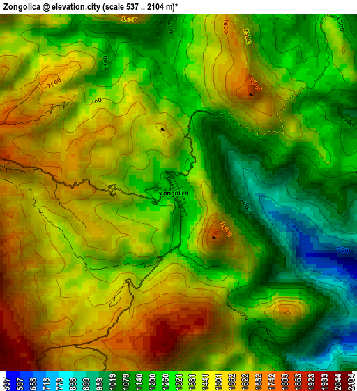
Below is the Elevation map of Zongolica, which displays elevation range with different colors. Scale of the first map is from 537 to 2104 m (1762 to 6903 ft) with average elevation of 1370.7 meters (=4497 ft) [note 1]
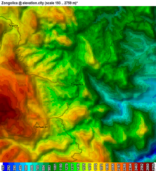
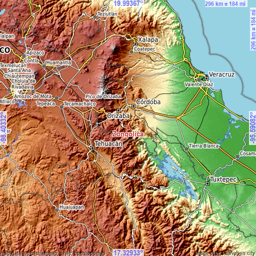
These maps also provides idea of topography and contour of this city, they are displayed at different zoom levels. More info about maps, scale and edge coordinates you can find below images.
| \ | Map #1 | Map #2 | Topo.Map |
| Scale [m] | 537..2104 m | 193..2759 m | × |
| Scale [ft] | 1762..6903 ft | 633..9052 ft | × |
| Average | 1370.7 m = 4497 ft | 1464.2 m = 4804 ft | × |
| Width | 9.26 km = 5.8 mi | 18.52 km = 11.5 mi | 296.2 km = 184 mi |
| Height | 9.26 km = 5.8 mi | 18.52 km = 11.5 mi | 296.3 km = 184.1 mi |
| ↑Max Latitude | 18.708359° | 18.749977° | 19.99367° |
| Latitude at center | 18.66673° | 18.66673° | 18.66673° |
| ↓Min Latitude | 18.625091° | 18.583442° | 17.32933° |
| ← Min Longitude | -97.041015° | -97.084961° | -98.40332° |
| Longitude center | -96.99707° | -96.99707° | -96.99707° |
| →Max Longitude | -96.953125° | -96.909179° | -95.59082° |
Nearby cities:
Cities around Zongolica sort by population:
• Tequila elevation 1696 m
10.4 km,  312°
312°
• Tuxpanguillo 810 m
13 km,  352°
352°
• Capoluca 813 m
15.8 km, 348°
• Texhuacán 1998 m
6.7 km,  222°
222°
• Coetzala 648 m
15.6 km,  32°
32°
• Tonalixco 1425 m
14.4 km,  332°
332°
• Atlahuilco 1760 m
10.5 km,  288°
288°
• San José Independencia 1191 m
11.3 km, 28°
• Los Reyes 1659 m
4.8 km,  275°
275°
• Tlaquilpa 2347 m
14.3 km,  243°
243°
• Astacinga 2317 m
15.6 km,  225°
225°
• Mixtla de Altamirano 1653 m
7.9 km,  176°
176°
Multilingual:
 En español:
Zongolica elevación 1219 m.
 En France:
Zongolica élévation 1219 m.
 Auf Deutsch:
Zongolica höhe über dem Meeresspiegel ist 1219 m.

Sources and notes:
- [note 1] Map square and city borders are not equal. Map elevation data is calculated only from area inside that square.
- [src 1] Elevation data from geonames database provided with same terms of usage.
- [src 2] The elevation map of Zongolica is generated using elevation data from NASA's 3 arcsec (90m) resolution SRTM data.
- [src 3] Base (background) map © OpenStreetMap contributors tiles are generated by Geofabrik and OpenTopoMap.
Copyright & License:
This Zongolica Elevation Map is licensed under CC BY-SA. You may reuse any part from this page, if you give a proper credit by linking to this URL:
 More info on terms of use page.