Tequila elevation
Tequila (Veracruz), Mexico elevation is 1696 meters and Tequila elevation in feet is 5564 ft above sea level [src 1]. Tequila is a seat of a second-order administrative division (feature code) with elevation that is 382 meters (1253 ft) bigger than average city elevation in Mexico.
Below is the Elevation map of Tequila, which displays elevation range with different colors. Scale of the first map is from 1129 to 2688 m (3704 to 8819 ft) with average elevation of 1894.6 meters (=6216 ft) [note 1]
These maps also provides idea of topography and contour of this city, they are displayed at different zoom levels. More info about maps, scale and edge coordinates you can find below images.
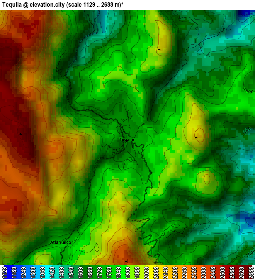
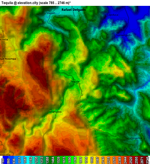
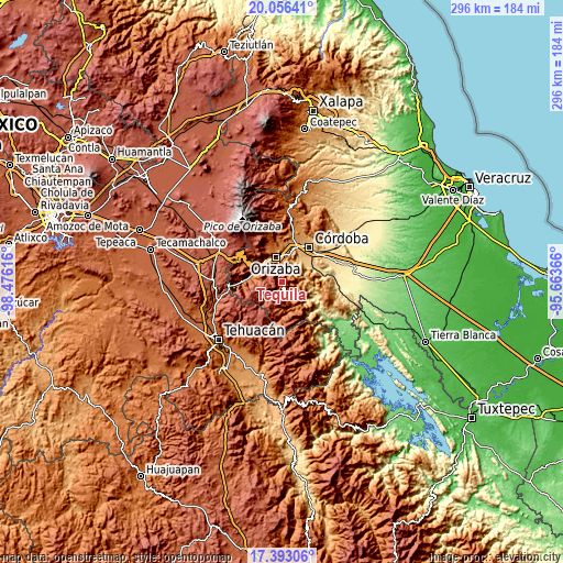
| \ | Map #1 | Map #2 | Topo.Map |
| Scale [m] | 1129..2688 m | 785..2746 m | × |
| Scale [ft] | 3704..8819 ft | 2575..9009 ft | × |
| Average | 1894.6 m = 6216 ft | 1776 m = 5827 ft | × |
| Width | 9.25 km = 5.7 mi | 18.51 km = 11.5 mi | 296.1 km = 184 mi |
| Height | 9.25 km = 5.7 mi | 18.51 km = 11.5 mi | 296.2 km = 184 mi |
| ↑Max Latitude | 18.771593° | 18.813196° | 20.05641° |
| Latitude at center | 18.72998° | 18.72998° | 18.72998° |
| ↓Min Latitude | 18.688357° | 18.646723° | 17.39306° |
| ← Min Longitude | -97.113855° | -97.157801° | -98.47616° |
| Longitude center | -97.06991° | -97.06991° | -97.06991° |
| →Max Longitude | -97.025965° | -96.982019° | -95.66366° |
Nearby cities:
Cities around Tequila sort by population:
• Rafael Delgado elevation 1171 m
8.9 km,  358°
358°
• Tuxpanguillo 810 m
8.4 km,  45°
45°
• Tlilapan 1171 m
8.9 km,  340°
340°
• Necoxtla 2047 m
10.3 km,  301°
301°
• Capoluca 813 m
9.6 km,  27°
27°
• Tonalixco 1425 m
5.9 km,  10°
10°
• Atlahuilco 1760 m
4.3 km,  212°
212°
• Tlatilpa 2225 m
7.8 km,  273°
273°
• Tlatzala 2262 m
7.5 km, 268°
• Los Reyes 1659 m
7.2 km,  156°
156°
• Soledad Atzompa 2108 m
8.9 km,  288°
288°
• San Andrés Tenejapan 1173 m
7.1 km, 338°
Multilingual:
 En español:
Tequila elevación 1696 m.
 En France:
Tequila élévation 1696 m.
 Auf Deutsch:
Tequila höhe über dem Meeresspiegel ist 1696 m.

Sources and notes:
- [note 1] Map square and city borders are not equal. Map elevation data is calculated only from area inside that square.
- [src 1] Elevation data from geonames database provided with same terms of usage.
- [src 2] The elevation map of Tequila is generated using elevation data from NASA's 3 arcsec (90m) resolution SRTM data.
- [src 3] Base (background) map © OpenStreetMap contributors tiles are generated by Geofabrik and OpenTopoMap.
Copyright & License:
This Tequila Elevation Map is licensed under CC BY-SA. You may reuse any part from this page, if you give a proper credit by linking to this URL:
 More info on terms of use page.