Tuxpanguillo elevation
Tuxpanguillo (Veracruz, Ixtaczoquitlán), Mexico elevation is 810 meters and Tuxpanguillo elevation in feet is 2657 ft above sea level [src 1]. Tuxpanguillo is a populated place (feature code) with elevation that is 504 meters (1654 ft) smaller than average city elevation in Mexico.
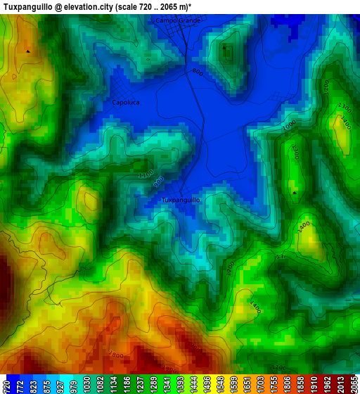
Below is the Elevation map of Tuxpanguillo, which displays elevation range with different colors. Scale of the first map is from 720 to 2065 m (2362 to 6775 ft) with average elevation of 1194.4 meters (=3919 ft) [note 1]
These maps also provides idea of topography and contour of this city, they are displayed at different zoom levels. More info about maps, scale and edge coordinates you can find below images.
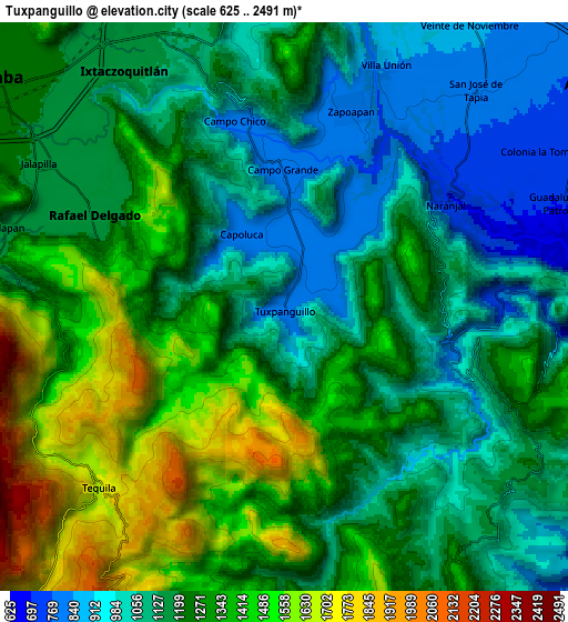
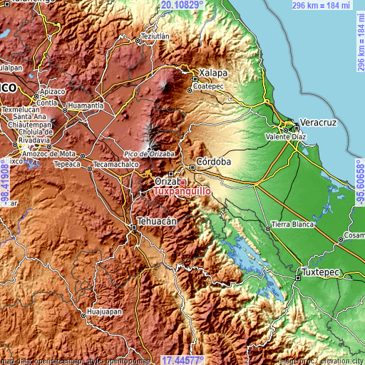
| \ | Map #1 | Map #2 | Topo.Map |
| Scale [m] | 720..2065 m | 625..2491 m | × |
| Scale [ft] | 2362..6775 ft | 2051..8173 ft | × |
| Average | 1194.4 m = 3919 ft | 1226 m = 4022 ft | × |
| Width | 9.25 km = 5.7 mi | 18.5 km = 11.5 mi | 296 km = 183.9 mi |
| Height | 9.25 km = 5.7 mi | 18.5 km = 11.5 mi | 296.1 km = 184 mi |
| ↑Max Latitude | 18.82389° | 18.86548° | 20.10829° |
| Latitude at center | 18.78229° | 18.78229° | 18.78229° |
| ↓Min Latitude | 18.74068° | 18.699059° | 17.44577° |
| ← Min Longitude | -97.056775° | -97.100721° | -98.41908° |
| Longitude center | -97.01283° | -97.01283° | -97.01283° |
| →Max Longitude | -96.968885° | -96.924939° | -95.60658° |
Nearby cities:
Cities around Tuxpanguillo sort by population:
• Rafael Delgado elevation 1171 m
6.9 km,  296°
296°
• Tequila 1696 m
8.4 km,  225°
225°
• Tlilapan 1171 m
9.4 km,  286°
286°
• Campo Grande 800 m
4.5 km,  0°
0°
• Zapoapan 806 m
6.8 km,  17°
17°
• Capoluca 813 m
3.1 km,  330°
330°
• Naranjal 736 m
6.1 km,  58°
58°
• Campo Chico 818 m
6.2 km,  345°
345°
• Villa Unión 843 m
8.6 km, 21°
• Tonalixco 1425 m
4.9 km,  269°
269°
• San José Independencia 1191 m
7.7 km,  112°
112°
• San Andrés Tenejapan 1173 m
8.6 km,  275°
275°
Multilingual:
 En español:
Tuxpanguillo elevación 810 m.
 En France:
Tuxpanguillo élévation 810 m.
 Auf Deutsch:
Tuxpanguillo höhe über dem Meeresspiegel ist 810 m.

Sources and notes:
- [note 1] Map square and city borders are not equal. Map elevation data is calculated only from area inside that square.
- [src 1] Elevation data from geonames database provided with same terms of usage.
- [src 2] The elevation map of Tuxpanguillo is generated using elevation data from NASA's 3 arcsec (90m) resolution SRTM data.
- [src 3] Base (background) map © OpenStreetMap contributors tiles are generated by Geofabrik and OpenTopoMap.
Copyright & License:
This Tuxpanguillo Elevation Map is licensed under CC BY-SA. You may reuse any part from this page, if you give a proper credit by linking to this URL:
 More info on terms of use page.