Mixtla de Altamirano elevation
Mixtla de Altamirano (Veracruz), Mexico elevation is 1653 meters and Mixtla de Altamirano elevation in feet is 5423 ft above sea level [src 1]. Mixtla de Altamirano is a seat of a second-order administrative division (feature code) with elevation that is 339 meters (1112 ft) bigger than average city elevation in Mexico.
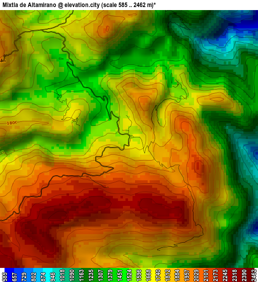
Below is the Elevation map of Mixtla de Altamirano, which displays elevation range with different colors. Scale of the first map is from 585 to 2462 m (1919 to 8077 ft) with average elevation of 1698.3 meters (=5572 ft) [note 1]
These maps also provides idea of topography and contour of this city, they are displayed at different zoom levels. More info about maps, scale and edge coordinates you can find below images.
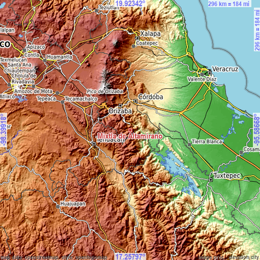
| \ | Map #1 | Topo.Map |
| Scale [m] | 585..2462 m | × |
| Scale [ft] | 1919..8077 ft | × |
| Average | 1698.3 m = 5572 ft | × |
| Width | 9.26 km = 5.8 mi | 296.4 km = 184.2 mi |
| Height | 9.26 km = 5.8 mi | 296.4 km = 184.2 mi |
| ↑Max Latitude | 18.637556° | 19.92342° |
| Latitude at center | 18.59591° | 18.59591° |
| ↓Min Latitude | 18.554254° | 17.25797° |
| ← Min Longitude | -97.036875° | -98.39918° |
| Longitude center | -96.99293° | -96.99293° |
| →Max Longitude | -96.948985° | -95.58668° |
Nearby cities:
Cities around Mixtla de Altamirano sort by population:
• Zongolica elevation 1219 m
7.9 km,  356°
356°
• Tecpantzacoalco 2123 m
14.1 km,  200°
200°
• Texhuacán 1998 m
5.8 km,  300°
300°
• Tehuipango 2358 m
10.7 km,  217°
217°
• Xopilapa 2483 m
13.6 km, 221°
• Eloxochitlán 1453 m
11.4 km,  158°
158°
• Cuaxuxpa 2309 m
15.5 km, 196°
• Atlahuilco 1760 m
15.3 km,  317°
317°
• Loma Bonita 1061 m
16.1 km,  124°
124°
• Los Reyes 1659 m
9.8 km,  327°
327°
• Tlaquilpa 2347 m
13.3 km,  276°
276°
• Astacinga 2317 m
12.1 km,  255°
255°
Multilingual:
 En español:
Mixtla de Altamirano elevación 1653 m.
 En France:
Mixtla de Altamirano élévation 1653 m.
 Auf Deutsch:
Mixtla de Altamirano höhe über dem Meeresspiegel ist 1653 m.
 На русском:
Mixtla de Altamirano высота над уровнем моря 1653 м
Sources and notes:
- [note 1] Map square and city borders are not equal. Map elevation data is calculated only from area inside that square.
- [src 1] Elevation data from geonames database provided with same terms of usage.
- [src 2] The elevation map of Mixtla de Altamirano is generated using elevation data from NASA's 3 arcsec (90m) resolution SRTM data.
- [src 3] Base (background) map © OpenStreetMap contributors tiles are generated by Geofabrik and OpenTopoMap.
Copyright & License:
This Mixtla de Altamirano Elevation Map is licensed under CC BY-SA. You may reuse any part from this page, if you give a proper credit by linking to this URL:
 More info on terms of use page.