Loma Bonita elevation
Loma Bonita (Puebla, Eloxochitlán), Mexico elevation is 1061 meters and Loma Bonita elevation in feet is 3481 ft above sea level [src 1]. Loma Bonita is a populated place (feature code) with elevation that is 253 meters (830 ft) smaller than average city elevation in Mexico.
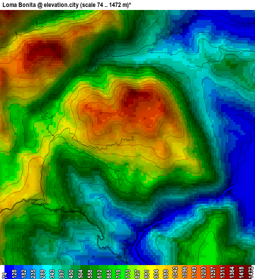
Below is the Elevation map of Loma Bonita, which displays elevation range with different colors. Scale of the first map is from 74 to 1472 m (243 to 4829 ft) with average elevation of 609.3 meters (=1999 ft) [note 1]
These maps also provides idea of topography and contour of this city, they are displayed at different zoom levels. More info about maps, scale and edge coordinates you can find below images.
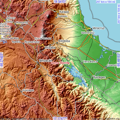
| \ | Map #1 | Topo.Map |
| Scale [m] | 74..1472 m | × |
| Scale [ft] | 243..4829 ft | × |
| Average | 609.3 m = 1999 ft | × |
| Width | 9.27 km = 5.8 mi | 296.5 km = 184.2 mi |
| Height | 9.27 km = 5.8 mi | 296.5 km = 184.2 mi |
| ↑Max Latitude | 18.554996° | 19.8415° |
| Latitude at center | 18.51333° | 18.51333° |
| ↓Min Latitude | 18.471654° | 17.17477° |
| ← Min Longitude | -96.911725° | -98.27403° |
| Longitude center | -96.86778° | -96.86778° |
| →Max Longitude | -96.823835° | -95.46153° |
Nearby cities:
Cities around Loma Bonita sort by population:
• Laguna Chica (Pueblo Nuevo) elevation 152 m
14.6 km,  76°
76°
• Caxapa 105 m
13.4 km,  132°
132°
• Eloxochitlán 1453 m
9.2 km,  260°
260°
• Tlacotepec 314 m
12.3 km,  171°
171°
• Ixtacapa el Chico 129 m
13.5 km,  101°
101°
• Huitzmaloc 1398 m
9.9 km,  230°
230°
• Coxolico 2317 m
18.4 km,  247°
247°
• San Agustín del Palmar 135 m
15.5 km,  88°
88°
• Palmar Grande 133 m
9.4 km, 88°
• San Martín Mazateopan 223 m
8.7 km,  141°
141°
• Rancho Nuevo 130 m
10.2 km,  70°
70°
• Mixtla de Altamirano 1653 m
16.1 km,  304°
304°
Multilingual:
 En español:
Loma Bonita elevación 1061 m.
 En France:
Loma Bonita élévation 1061 m.
 Auf Deutsch:
Loma Bonita höhe über dem Meeresspiegel ist 1061 m.

Sources and notes:
- [note 1] Map square and city borders are not equal. Map elevation data is calculated only from area inside that square.
- [src 1] Elevation data from geonames database provided with same terms of usage.
- [src 2] The elevation map of Loma Bonita is generated using elevation data from NASA's 3 arcsec (90m) resolution SRTM data.
- [src 3] Base (background) map © OpenStreetMap contributors tiles are generated by Geofabrik and OpenTopoMap.
Copyright & License:
This Loma Bonita Elevation Map is licensed under CC BY-SA. You may reuse any part from this page, if you give a proper credit by linking to this URL:
 More info on terms of use page.