Huitzmaloc elevation
Huitzmaloc (Puebla, Ajalpan), Mexico elevation is 1398 meters and Huitzmaloc elevation in feet is 4587 ft above sea level [src 1]. Huitzmaloc is a populated place (feature code) with elevation that is 84 meters (276 ft) bigger than average city elevation in Mexico.
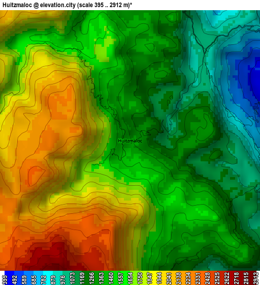
Below is the Elevation map of Huitzmaloc, which displays elevation range with different colors. Scale of the first map is from 395 to 2912 m (1296 to 9554 ft) with average elevation of 1587.6 meters (=5209 ft) [note 1]
These maps also provides idea of topography and contour of this city, they are displayed at different zoom levels. More info about maps, scale and edge coordinates you can find below images.
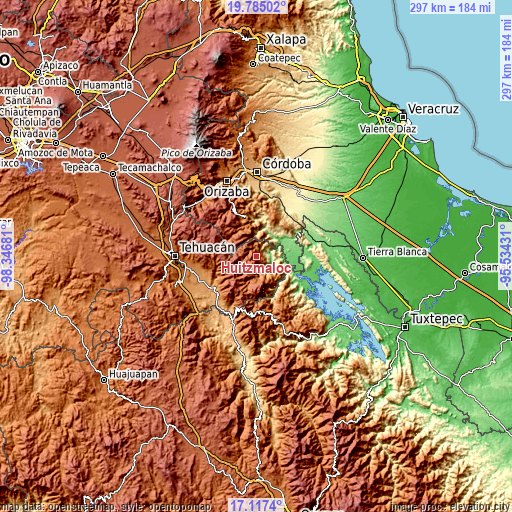
| \ | Map #1 | Topo.Map |
| Scale [m] | 395..2912 m | × |
| Scale [ft] | 1296..9554 ft | × |
| Average | 1587.6 m = 5209 ft | × |
| Width | 9.27 km = 5.8 mi | 296.6 km = 184.3 mi |
| Height | 9.27 km = 5.8 mi | 296.6 km = 184.3 mi |
| ↑Max Latitude | 18.49807° | 19.78502° |
| Latitude at center | 18.45639° | 18.45639° |
| ↓Min Latitude | 18.4147° | 17.1174° |
| ← Min Longitude | -96.984505° | -98.34681° |
| Longitude center | -96.94056° | -96.94056° |
| →Max Longitude | -96.896615° | -95.53431° |
Nearby cities:
Cities around Huitzmaloc sort by population:
• Acatepec elevation 2544 m
13.8 km,  227°
227°
• Tecpantzacoalco 2123 m
10.7 km,  282°
282°
• Tehuipango 2358 m
13.9 km,  300°
300°
• Xopilapa 2483 m
15.6 km,  290°
290°
• Eloxochitlán 1453 m
5 km,  344°
344°
• Cuaxuxpa 2309 m
10 km,  273°
273°
• San Sebastián Alcomunga 2237 m
9.4 km,  256°
256°
• Tlacotepec 314 m
11.1 km,  121°
121°
• Coxolico 2317 m
9.4 km, 266°
• Chichicapa 2505 m
12.8 km,  241°
241°
• San Martín Mazateopan 223 m
13.1 km,  91°
91°
• Loma Bonita 1061 m
9.9 km,  50°
50°
Multilingual:
 En español:
Huitzmaloc elevación 1398 m.
 En France:
Huitzmaloc élévation 1398 m.
 Auf Deutsch:
Huitzmaloc höhe über dem Meeresspiegel ist 1398 m.

Sources and notes:
- [note 1] Map square and city borders are not equal. Map elevation data is calculated only from area inside that square.
- [src 1] Elevation data from geonames database provided with same terms of usage.
- [src 2] The elevation map of Huitzmaloc is generated using elevation data from NASA's 3 arcsec (90m) resolution SRTM data.
- [src 3] Base (background) map © OpenStreetMap contributors tiles are generated by Geofabrik and OpenTopoMap.
Copyright & License:
This Huitzmaloc Elevation Map is licensed under CC BY-SA. You may reuse any part from this page, if you give a proper credit by linking to this URL:
 More info on terms of use page.