Texhuacán elevation
Texhuacán (Veracruz), Mexico elevation is 1998 meters and Texhuacán elevation in feet is 6555 ft above sea level [src 1]. Texhuacán is a seat of a second-order administrative division (feature code) with elevation that is 684 meters (2244 ft) bigger than average city elevation in Mexico.
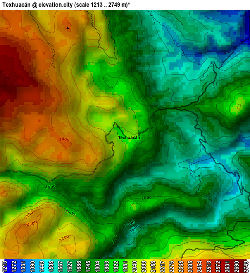
Below is the Elevation map of Texhuacán, which displays elevation range with different colors. Scale of the first map is from 1213 to 2749 m (3980 to 9019 ft) with average elevation of 1911.5 meters (=6271 ft) [note 1]
These maps also provides idea of topography and contour of this city, they are displayed at different zoom levels. More info about maps, scale and edge coordinates you can find below images.
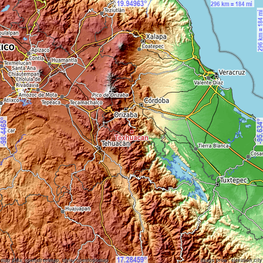
| \ | Map #1 | Topo.Map |
| Scale [m] | 1213..2749 m | × |
| Scale [ft] | 3980..9019 ft | × |
| Average | 1911.5 m = 6271 ft | × |
| Width | 9.26 km = 5.8 mi | 296.3 km = 184.1 mi |
| Height | 9.26 km = 5.8 mi | 296.3 km = 184.1 mi |
| ↑Max Latitude | 18.663969° | 19.94963° |
| Latitude at center | 18.62233° | 18.62233° |
| ↓Min Latitude | 18.58068° | 17.28459° |
| ← Min Longitude | -97.084195° | -98.4465° |
| Longitude center | -97.04025° | -97.04025° |
| →Max Longitude | -96.996305° | -95.634° |
Nearby cities:
Cities around Texhuacán sort by population:
• Zongolica elevation 1219 m
6.7 km,  42°
42°
• Tequila 1696 m
12.4 km,  345°
345°
• Xoxocotla 2125 m
12.1 km,  282°
282°
• Tehuipango 2358 m
11.5 km,  187°
187°
• Xopilapa 2483 m
13.7 km,  197°
197°
• Alhuaca 2683 m
14.6 km,  245°
245°
• Mexcala 2364 m
15.4 km,  301°
301°
• Atlahuilco 1760 m
9.9 km,  326°
326°
• Los Reyes 1659 m
5.4 km,  357°
357°
• Tlaquilpa 2347 m
8.4 km,  260°
260°
• Astacinga 2317 m
8.9 km,  228°
228°
• Mixtla de Altamirano 1653 m
5.8 km,  120°
120°
Multilingual:
 En español:
Texhuacán elevación 1998 m.
 En France:
Texhuacán élévation 1998 m.
 Auf Deutsch:
Texhuacán höhe über dem Meeresspiegel ist 1998 m.

Sources and notes:
- [note 1] Map square and city borders are not equal. Map elevation data is calculated only from area inside that square.
- [src 1] Elevation data from geonames database provided with same terms of usage.
- [src 2] The elevation map of Texhuacán is generated using elevation data from NASA's 3 arcsec (90m) resolution SRTM data.
- [src 3] Base (background) map © OpenStreetMap contributors tiles are generated by Geofabrik and OpenTopoMap.
Copyright & License:
This Texhuacán Elevation Map is licensed under CC BY-SA. You may reuse any part from this page, if you give a proper credit by linking to this URL:
 More info on terms of use page.