Magdaleno Cedillo elevation
Magdaleno Cedillo (Tamaulipas, Tula), Mexico elevation is 1032 meters and Magdaleno Cedillo elevation in feet is 3386 ft above sea level [src 1]. Magdaleno Cedillo is a populated place (feature code) with elevation that is 282 meters (925 ft) smaller than average city elevation in Mexico.
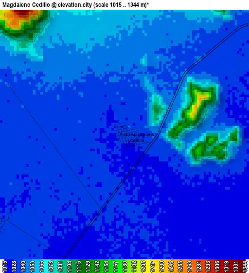
Below is the Elevation map of Magdaleno Cedillo, which displays elevation range with different colors. Scale of the first map is from 1015 to 1344 m (3330 to 4409 ft) with average elevation of 1042 meters (=3419 ft) [note 1]
These maps also provides idea of topography and contour of this city, they are displayed at different zoom levels. More info about maps, scale and edge coordinates you can find below images.
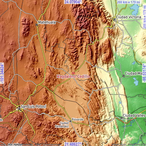
| \ | Map #1 | Topo.Map |
| Scale [m] | 1015..1344 m | × |
| Scale [ft] | 3330..4409 ft | × |
| Average | 1042 m = 3419 ft | × |
| Width | 9.01 km = 5.6 mi | 288.3 km = 179.1 mi |
| Height | 9.01 km = 5.6 mi | 288.3 km = 179.1 mi |
| ↑Max Latitude | 22.829329° | 24.07904° |
| Latitude at center | 22.78882° | 22.78882° |
| ↓Min Latitude | 22.748299° | 21.48627° |
| ← Min Longitude | -99.981935° | -101.34424° |
| Longitude center | -99.93799° | -99.93799° |
| →Max Longitude | -99.894045° | -98.53174° |
Nearby cities:
Cities around Magdaleno Cedillo sort by population:
• Cerritos elevation 1145 m
53.6 km,  221°
221°
• Ciudad del Maíz 1243 m
55 km,  141°
141°
• Ciudad Tula 1179 m
32.8 km,  45°
45°
• Palomas 1023 m
35.4 km,  165°
165°
• Granjenal 1089 m
46 km,  196°
196°
• Entronque de Matehuala (El Huizache) 1420 m
55.5 km,  285°
285°
• Zamachihue 1283 m
42.4 km, 137°
• Palo Seco (El Gato) 1114 m
54.9 km,  208°
208°
• Ojo de Agua 1160 m
41.5 km, 202°
• Guadalcázar 1655 m
51 km,  248°
248°
• Lázaro Cárdenas 1108 m
23.5 km,  329°
329°
• Negritas 1166 m
22.8 km,  271°
271°
Multilingual:
 En español:
Magdaleno Cedillo elevación 1032 m.
 En France:
Magdaleno Cedillo élévation 1032 m.
 Auf Deutsch:
Magdaleno Cedillo höhe über dem Meeresspiegel ist 1032 m.
 На русском:
Magdaleno Cedillo высота над уровнем моря 1032 м
Sources and notes:
- [note 1] Map square and city borders are not equal. Map elevation data is calculated only from area inside that square.
- [src 1] Elevation data from geonames database provided with same terms of usage.
- [src 2] The elevation map of Magdaleno Cedillo is generated using elevation data from NASA's 3 arcsec (90m) resolution SRTM data.
- [src 3] Base (background) map © OpenStreetMap contributors tiles are generated by Geofabrik and OpenTopoMap.
Copyright & License:
This Magdaleno Cedillo Elevation Map is licensed under CC BY-SA. You may reuse any part from this page, if you give a proper credit by linking to this URL:
 More info on terms of use page.