Ciudad Tula elevation
Ciudad Tula (Tamaulipas, Tula), Mexico elevation is 1179 meters and Ciudad Tula elevation in feet is 3868 ft above sea level [src 1]. Ciudad Tula is a seat of a second-order administrative division (feature code) with elevation that is 135 meters (443 ft) smaller than average city elevation in Mexico.
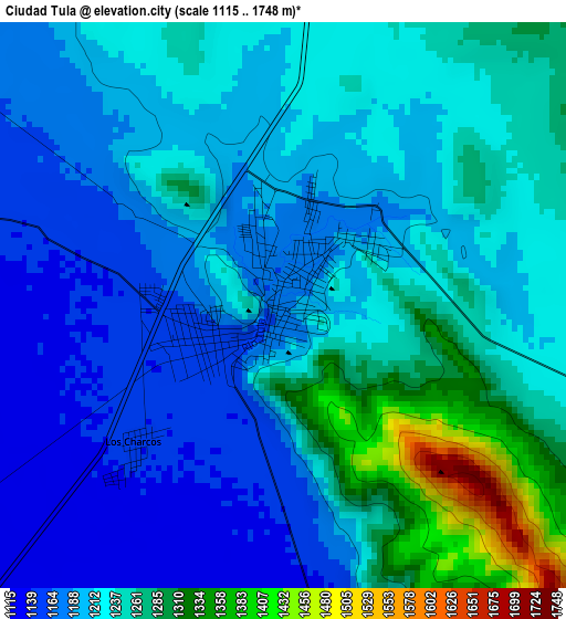
Below is the Elevation map of Ciudad Tula, which displays elevation range with different colors. Scale of the first map is from 1115 to 1748 m (3658 to 5735 ft) with average elevation of 1223.6 meters (=4014 ft) [note 1]
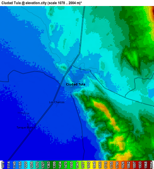
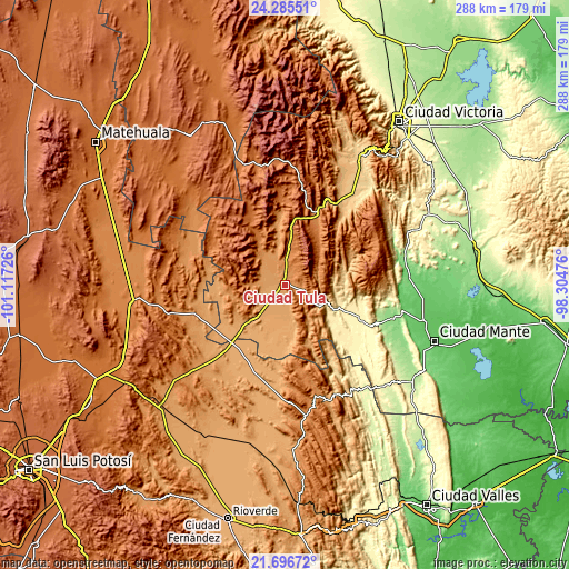
These maps also provides idea of topography and contour of this city, they are displayed at different zoom levels. More info about maps, scale and edge coordinates you can find below images.
| \ | Map #1 | Map #2 | Topo.Map |
| Scale [m] | 1115..1748 m | 1078..2004 m | × |
| Scale [ft] | 3658..5735 ft | 3537..6575 ft | × |
| Average | 1223.6 m = 4014 ft | 1237.3 m = 4059 ft | × |
| Width | 9 km = 5.6 mi | 17.99 km = 11.2 mi | 287.8 km = 178.8 mi |
| Height | 9 km = 5.6 mi | 17.99 km = 11.2 mi | 287.9 km = 178.9 mi |
| ↑Max Latitude | 23.037767° | 23.078201° | 24.28551° |
| Latitude at center | 22.99732° | 22.99732° | 22.99732° |
| ↓Min Latitude | 22.956861° | 22.91639° | 21.69672° |
| ← Min Longitude | -99.754955° | -99.798901° | -101.11726° |
| Longitude center | -99.71101° | -99.71101° | -99.71101° |
| →Max Longitude | -99.667065° | -99.623119° | -98.30476° |
Nearby cities:
Cities around Ciudad Tula sort by population:
• Jaumave elevation 753 m
56.6 km,  36°
36°
• Ocampo 355 m
41.6 km,  113°
113°
• Palomas 1023 m
59.1 km,  193°
193°
• Miquihuana 1863 m
64.5 km,  356°
356°
• Zamachihue 1283 m
54.5 km,  174°
174°
• Bustamante 1694 m
48.9 km,  354°
354°
• Magdaleno Cedillo 1032 m
32.8 km,  225°
225°
• Mier y Noriega 1678 m
62.9 km,  318°
318°
• Palmillas 1267 m
37.7 km,  26°
26°
• Lázaro Cárdenas 1108 m
35.2 km,  265°
265°
• Negritas 1166 m
51.3 km,  243°
243°
• Juamave 753 m
56.6 km, 36°
Multilingual:
 En español:
Ciudad Tula, Tula elevación 1179 m.
 En France:
Ciudad Tula élévation 1179 m.
 Auf Deutsch:
Ciudad Tula höhe über dem Meeresspiegel ist 1179 m.

Sources and notes:
- [note 1] Map square and city borders are not equal. Map elevation data is calculated only from area inside that square.
- [src 1] Elevation data from geonames database provided with same terms of usage.
- [src 2] The elevation map of Ciudad Tula is generated using elevation data from NASA's 3 arcsec (90m) resolution SRTM data.
- [src 3] Base (background) map © OpenStreetMap contributors tiles are generated by Geofabrik and OpenTopoMap.
Copyright & License:
This Ciudad Tula Elevation Map is licensed under CC BY-SA. You may reuse any part from this page, if you give a proper credit by linking to this URL:
 More info on terms of use page.