Jaumave elevation
Jaumave (Tamaulipas), Mexico elevation is 753 meters and Jaumave elevation in feet is 2470 ft above sea level [src 1]. Jaumave is a seat of a second-order administrative division (feature code) with elevation that is 561 meters (1841 ft) smaller than average city elevation in Mexico.
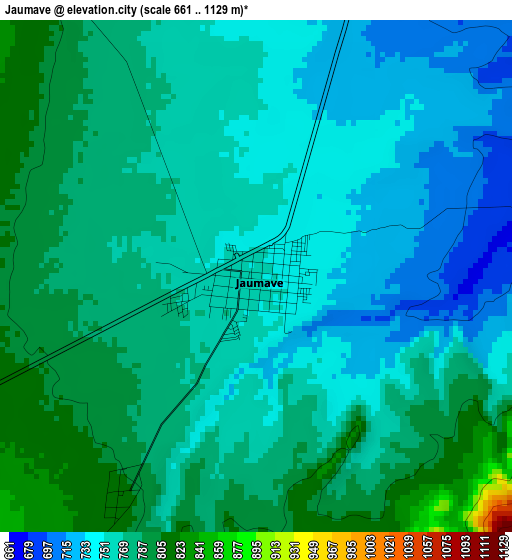
Below is the Elevation map of Jaumave, which displays elevation range with different colors. Scale of the first map is from 661 to 1129 m (2169 to 3704 ft) with average elevation of 765.7 meters (=2512 ft) [note 1]
These maps also provides idea of topography and contour of this city, they are displayed at different zoom levels. More info about maps, scale and edge coordinates you can find below images.
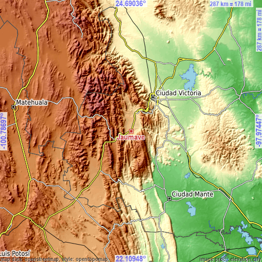
| \ | Map #1 | Map #2 | Topo.Map |
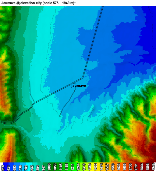
| Scale [m] | 661..1129 m | 578..1949 m | × |
| Scale [ft] | 2169..3704 ft | 1896..6394 ft | × |
| Average | 765.7 m = 2512 ft | 905.6 m = 2971 ft | × |
| Width | 8.97 km = 5.6 mi | 17.94 km = 11.1 mi | 287 km = 178.3 mi |
| Height | 8.97 km = 5.6 mi | 17.94 km = 11.1 mi | 287 km = 178.3 mi |
| ↑Max Latitude | 23.446533° | 23.486844° | 24.69036° |
| Latitude at center | 23.40621° | 23.40621° | 23.40621° |
| ↓Min Latitude | 23.365875° | 23.325527° | 22.10948° |
| ← Min Longitude | -99.424665° | -99.468611° | -100.78697° |
| Longitude center | -99.38072° | -99.38072° | -99.38072° |
| →Max Longitude | -99.336775° | -99.292829° | -97.97447° |
Nearby cities:
Cities around Jaumave sort by population:
• Ciudad Victoria elevation 318 m
44.3 km,  32°
32°
• Ciudad Tula 1179 m
56.6 km,  216°
216°
• Xicoténcatl 95 m
63.9 km,  135°
135°
• Ocampo 355 m
62.3 km,  176°
176°
• Llera de Canales 277 m
37.5 km,  105°
105°
• Primero de Mayo 90 m
66.3 km, 138°
• Miquihuana 1863 m
42.5 km,  296°
296°
• Bustamante 1694 m
38.7 km,  274°
274°
• La Libertad 319 m
46.9 km,  24°
24°
• Palmillas 1267 m
20.7 km,  236°
236°
• La Misión 287 m
49.1 km, 25°
• Juamave 753 m
0.1 km,  149°
149°
Multilingual:
 En español:
Jaumave elevación 753 m.
 En France:
Jaumave élévation 753 m.


Sources and notes:
- [note 1] Map square and city borders are not equal. Map elevation data is calculated only from area inside that square.
- [src 1] Elevation data from geonames database provided with same terms of usage.
- [src 2] The elevation map of Jaumave is generated using elevation data from NASA's 3 arcsec (90m) resolution SRTM data.
- [src 3] Base (background) map © OpenStreetMap contributors tiles are generated by Geofabrik and OpenTopoMap.
Copyright & License:
This Jaumave Elevation Map is licensed under CC BY-SA. You may reuse any part from this page, if you give a proper credit by linking to this URL:
 More info on terms of use page.