Llera de Canales elevation
Llera de Canales (Tamaulipas, Llera), Mexico elevation is 277 meters and Llera de Canales elevation in feet is 909 ft above sea level [src 1]. Llera de Canales is a seat of a second-order administrative division (feature code) with elevation that is 1037 meters (3402 ft) smaller than average city elevation in Mexico.
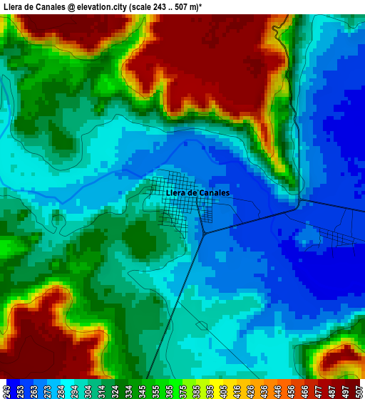
Below is the Elevation map of Llera de Canales, which displays elevation range with different colors. Scale of the first map is from 243 to 507 m (797 to 1663 ft) with average elevation of 332.6 meters (=1091 ft) [note 1]
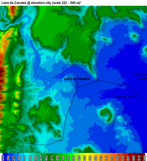
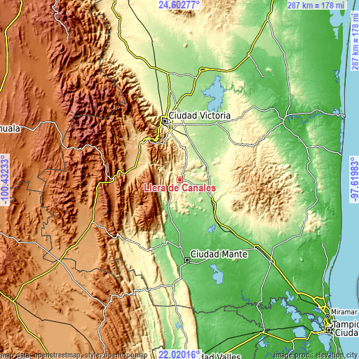
These maps also provides idea of topography and contour of this city, they are displayed at different zoom levels. More info about maps, scale and edge coordinates you can find below images.
| \ | Map #1 | Map #2 | Topo.Map |
| Scale [m] | 243..507 m | 222..940 m | × |
| Scale [ft] | 797..1663 ft | 728..3084 ft | × |
| Average | 332.6 m = 1091 ft | 368 m = 1207 ft | × |
| Width | 8.97 km = 5.6 mi | 17.95 km = 11.2 mi | 287.2 km = 178.5 mi |
| Height | 8.97 km = 5.6 mi | 17.95 km = 11.2 mi | 287.2 km = 178.5 mi |
| ↑Max Latitude | 23.35809° | 23.398428° | 24.60277° |
| Latitude at center | 23.31774° | 23.31774° | 23.31774° |
| ↓Min Latitude | 23.277378° | 23.237003° | 22.02016° |
| ← Min Longitude | -99.070025° | -99.113971° | -100.43233° |
| Longitude center | -99.02608° | -99.02608° | -99.02608° |
| →Max Longitude | -98.982135° | -98.938189° | -97.61983° |
Nearby cities:
Cities around Llera de Canales sort by population:
• Ciudad Victoria elevation 318 m
48.7 km,  345°
345°
• Xicoténcatl 95 m
36.8 km,  166°
166°
• Jaumave 753 m
37.5 km,  285°
285°
• Ocampo 355 m
61.3 km,  211°
211°
• El Limón 69 m
54.8 km,  177°
177°
• Primero de Mayo 90 m
40.5 km, 168°
• La Libertad 319 m
55.2 km,  342°
342°
• Palmillas 1267 m
53.4 km,  268°
268°
• La Misión 287 m
55.9 km, 344°
• Casas 160 m
54.2 km,  32°
32°
• Gómez Farías 80 m
48.3 km, 180°
• Juamave 753 m
37.5 km, 285°
Multilingual:
 En español:
Llera de Canales elevación 277 m.
 En France:
Llera de Canales élévation 277 m.
 Auf Deutsch:
Llera de Canales höhe über dem Meeresspiegel ist 277 m.

Sources and notes:
- [note 1] Map square and city borders are not equal. Map elevation data is calculated only from area inside that square.
- [src 1] Elevation data from geonames database provided with same terms of usage.
- [src 2] The elevation map of Llera de Canales is generated using elevation data from NASA's 3 arcsec (90m) resolution SRTM data.
- [src 3] Base (background) map © OpenStreetMap contributors tiles are generated by Geofabrik and OpenTopoMap.
Copyright & License:
This Llera de Canales Elevation Map is licensed under CC BY-SA. You may reuse any part from this page, if you give a proper credit by linking to this URL:
 More info on terms of use page.