Casas elevation
Casas (Tamaulipas), Mexico elevation is 160 meters and Casas elevation in feet is 525 ft above sea level [src 1]. Casas is a seat of a second-order administrative division (feature code) with elevation that is 1154 meters (3786 ft) smaller than average city elevation in Mexico.
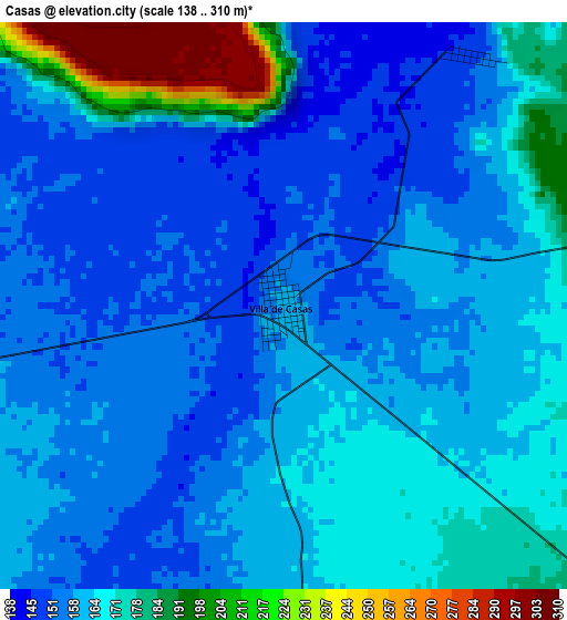
Below is the Elevation map of Casas, which displays elevation range with different colors. Scale of the first map is from 138 to 310 m (453 to 1017 ft) with average elevation of 164.9 meters (=541 ft) [note 1]
These maps also provides idea of topography and contour of this city, they are displayed at different zoom levels. More info about maps, scale and edge coordinates you can find below images.
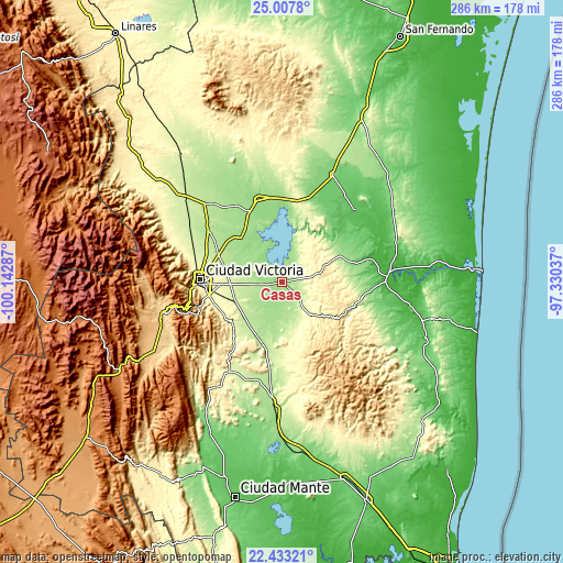
| \ | Map #1 | Topo.Map |
| Scale [m] | 138..310 m | × |
| Scale [ft] | 453..1017 ft | × |
| Average | 164.9 m = 541 ft | × |
| Width | 8.95 km = 5.6 mi | 286.3 km = 177.9 mi |
| Height | 8.95 km = 5.6 mi | 286.3 km = 177.9 mi |
| ↑Max Latitude | 23.767085° | 25.0078° |
| Latitude at center | 23.72686° | 23.72686° |
| ↓Min Latitude | 23.686623° | 22.43321° |
| ← Min Longitude | -98.780565° | -100.14287° |
| Longitude center | -98.73662° | -98.73662° |
| →Max Longitude | -98.692675° | -97.33037° |
Nearby cities:
Cities around Casas sort by population:
• Ciudad Victoria elevation 318 m
41.7 km,  272°
272°
• Soto la Marina 20 m
54.4 km,  84°
84°
• Guillermo Zúñiga 221 m
57.1 km,  304°
304°
• Estación Santa Engracia 219 m
57.2 km, 304°
• Abasolo 71 m
52.2 km,  45°
45°
• Nueva Villa de Padilla 156 m
39.4 km,  334°
334°
• Llera de Canales 277 m
54.2 km,  212°
212°
• Barretal 201 m
56 km,  315°
315°
• Guemes 170 m
34.7 km,  307°
307°
• La Libertad 319 m
46.8 km,  278°
278°
• Tampiquito 48 m
56.4 km, 77°
• La Misión 287 m
44.9 km, 280°
Multilingual:
 En español:
Casas elevación 160 m.
 En France:
Casas élévation 160 m.


Sources and notes:
- [note 1] Map square and city borders are not equal. Map elevation data is calculated only from area inside that square.
- [src 1] Elevation data from geonames database provided with same terms of usage.
- [src 2] The elevation map of Casas is generated using elevation data from NASA's 3 arcsec (90m) resolution SRTM data.
- [src 3] Base (background) map © OpenStreetMap contributors tiles are generated by Geofabrik and OpenTopoMap.
Copyright & License:
This Casas Elevation Map is licensed under CC BY-SA. You may reuse any part from this page, if you give a proper credit by linking to this URL:
 More info on terms of use page.