Zamachihue elevation
Zamachihue (San Luis Potosí, Ciudad del Maíz), Mexico elevation is 1283 meters and Zamachihue elevation in feet is 4209 ft above sea level [src 1]. Zamachihue is a populated place (feature code) with elevation that is 31 meters (102 ft) smaller than average city elevation in Mexico.
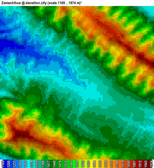
Below is the Elevation map of Zamachihue, which displays elevation range with different colors. Scale of the first map is from 1169 to 1974 m (3835 to 6476 ft) with average elevation of 1477.6 meters (=4848 ft) [note 1]
These maps also provides idea of topography and contour of this city, they are displayed at different zoom levels. More info about maps, scale and edge coordinates you can find below images.
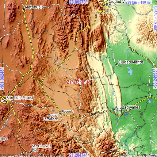
| \ | Map #1 | Topo.Map |
| Scale [m] | 1169..1974 m | × |
| Scale [ft] | 3835..6476 ft | × |
| Average | 1477.6 m = 4848 ft | × |
| Width | 9.03 km = 5.6 mi | 288.9 km = 179.5 mi |
| Height | 9.03 km = 5.6 mi | 288.9 km = 179.5 mi |
| ↑Max Latitude | 22.550451° | 23.80278° |
| Latitude at center | 22.50986° | 22.50986° |
| ↓Min Latitude | 22.469257° | 21.20474° |
| ← Min Longitude | -99.700145° | -101.06245° |
| Longitude center | -99.6562° | -99.6562° |
| →Max Longitude | -99.612255° | -98.24995° |
Nearby cities:
Cities around Zamachihue sort by population:
• El Naranjo elevation 281 m
33.6 km,  86°
86°
• Ciudad del Maíz 1243 m
13.1 km,  156°
156°
• Ocampo 355 m
49.7 km,  40°
40°
• Palomas 1023 m
20.1 km,  260°
260°
• Nuevo Morelos 284 m
45 km, 86°
• Granjenal 1089 m
44.4 km,  252°
252°
• Magdaleno Cedillo 1032 m
42.4 km,  317°
317°
• Colonia Álvaro Obregón 1144 m
28.7 km,  183°
183°
• Ojo de Agua 1160 m
45.5 km, 260°
• Alaquines 1284 m
42.6 km,  172°
172°
• Martinez 1318 m
49.2 km, 176°
• Maitinez 322 m
40.4 km,  112°
112°
Multilingual:
 En español:
Zamachihue elevación 1283 m.
 En France:
Zamachihue élévation 1283 m.
 Auf Deutsch:
Zamachihue höhe über dem Meeresspiegel ist 1283 m.

Sources and notes:
- [note 1] Map square and city borders are not equal. Map elevation data is calculated only from area inside that square.
- [src 1] Elevation data from geonames database provided with same terms of usage.
- [src 2] The elevation map of Zamachihue is generated using elevation data from NASA's 3 arcsec (90m) resolution SRTM data.
- [src 3] Base (background) map © OpenStreetMap contributors tiles are generated by Geofabrik and OpenTopoMap.
Copyright & License:
This Zamachihue Elevation Map is licensed under CC BY-SA. You may reuse any part from this page, if you give a proper credit by linking to this URL:
 More info on terms of use page.