Ciudad del Maíz elevation
Ciudad del Maíz (San Luis Potosí), Mexico elevation is 1243 meters and Ciudad del Maíz elevation in feet is 4078 ft above sea level [src 1]. Ciudad del Maíz is a seat of a second-order administrative division (feature code) with elevation that is 71 meters (233 ft) smaller than average city elevation in Mexico.
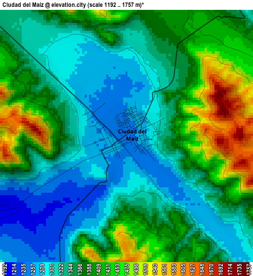
Below is the Elevation map of Ciudad del Maíz, which displays elevation range with different colors. Scale of the first map is from 1192 to 1757 m (3911 to 5764 ft) with average elevation of 1361.8 meters (=4468 ft) [note 1]
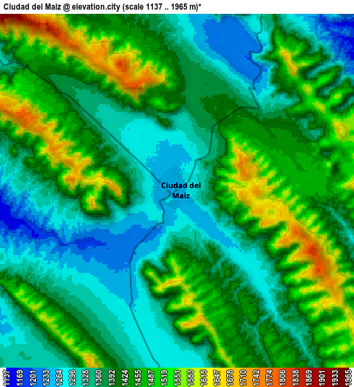
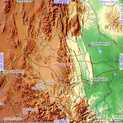
These maps also provides idea of topography and contour of this city, they are displayed at different zoom levels. More info about maps, scale and edge coordinates you can find below images.
| \ | Map #1 | Map #2 | Topo.Map |
| Scale [m] | 1192..1757 m | 1137..1965 m | × |
| Scale [ft] | 3911..5764 ft | 3730..6447 ft | × |
| Average | 1361.8 m = 4468 ft | 1409.7 m = 4625 ft | × |
| Width | 9.03 km = 5.6 mi | 18.07 km = 11.2 mi | 289.1 km = 179.6 mi |
| Height | 9.04 km = 5.6 mi | 18.07 km = 11.2 mi | 289.1 km = 179.6 mi |
| ↑Max Latitude | 22.442493° | 22.483104° | 23.69582° |
| Latitude at center | 22.40187° | 22.40187° | 22.40187° |
| ↓Min Latitude | 22.361235° | 22.320588° | 21.09576° |
| ← Min Longitude | -99.648625° | -99.692571° | -101.01093° |
| Longitude center | -99.60468° | -99.60468° | -99.60468° |
| →Max Longitude | -99.560735° | -99.516789° | -98.19843° |
Nearby cities:
Cities around Ciudad del Maíz sort by population:
• Cárdenas elevation 1220 m
44.7 km,  184°
184°
• El Naranjo 281 m
31.4 km,  63°
63°
• Palomas 1023 m
26.6 km,  289°
289°
• Nuevo Morelos 284 m
42.3 km,  69°
69°
• Damian Carmona 360 m
46.7 km,  136°
136°
• Ampliación la Hincada 228 m
43.2 km,  118°
118°
• San Francisco 1023 m
44.9 km,  215°
215°
• Zamachihue 1283 m
13.1 km,  336°
336°
• Colonia Álvaro Obregón 1144 m
18.1 km,  203°
203°
• Alaquines 1284 m
30.3 km, 179°
• Martinez 1318 m
37.2 km, 183°
• Maitinez 322 m
32.2 km,  95°
95°
Multilingual:
 En español:
Ciudad del Maiz elevación 1243 m.
 En France:
Ciudad del Maíz élévation 1243 m.
 Auf Deutsch:
Ciudad del Maíz höhe über dem Meeresspiegel ist 1243 m.

Sources and notes:
- [note 1] Map square and city borders are not equal. Map elevation data is calculated only from area inside that square.
- [src 1] Elevation data from geonames database provided with same terms of usage.
- [src 2] The elevation map of Ciudad del Maíz is generated using elevation data from NASA's 3 arcsec (90m) resolution SRTM data.
- [src 3] Base (background) map © OpenStreetMap contributors tiles are generated by Geofabrik and OpenTopoMap.
Copyright & License:
This Ciudad del Maíz Elevation Map is licensed under CC BY-SA. You may reuse any part from this page, if you give a proper credit by linking to this URL:
 More info on terms of use page.