Cárdenas elevation
Cárdenas (San Luis Potosí), Mexico elevation is 1220 meters and Cárdenas elevation in feet is 4003 ft above sea level [src 1]. Cárdenas is a seat of a second-order administrative division (feature code) with elevation that is 94 meters (308 ft) smaller than average city elevation in Mexico.
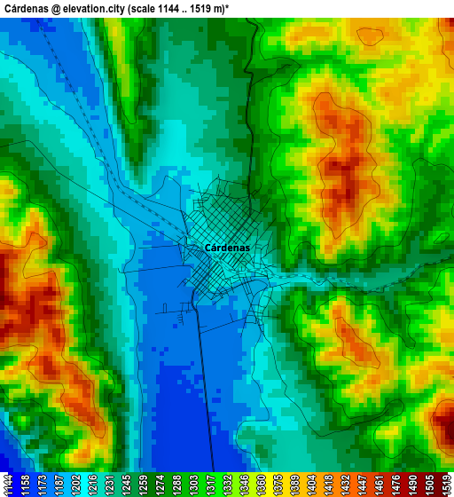
Below is the Elevation map of Cárdenas, which displays elevation range with different colors. Scale of the first map is from 1144 to 1519 m (3753 to 4984 ft) with average elevation of 1280.3 meters (=4200 ft) [note 1]
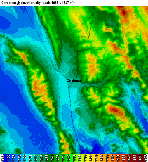
These maps also provides idea of topography and contour of this city, they are displayed at different zoom levels. More info about maps, scale and edge coordinates you can find below images.
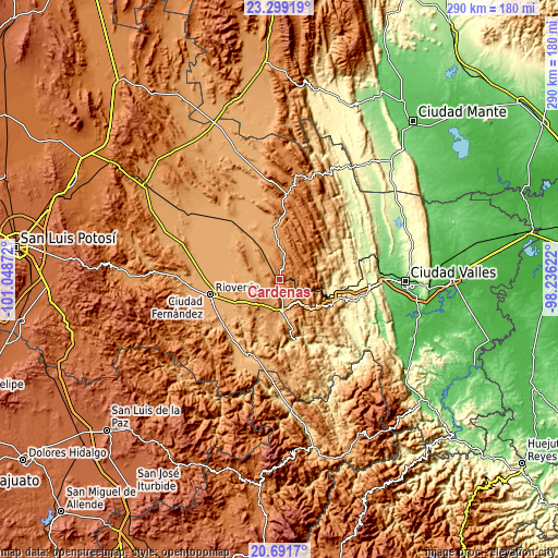
| \ | Map #1 | Map #2 | Topo.Map |
| Scale [m] | 1144..1519 m | 1085..1637 m | × |
| Scale [ft] | 3753..4984 ft | 3560..5371 ft | × |
| Average | 1280.3 m = 4200 ft | 1256.8 m = 4123 ft | × |
| Width | 9.06 km = 5.6 mi | 18.12 km = 11.3 mi | 289.9 km = 180.1 mi |
| Height | 9.06 km = 5.6 mi | 18.12 km = 11.3 mi | 289.9 km = 180.1 mi |
| ↑Max Latitude | 22.042179° | 22.082907° | 23.29919° |
| Latitude at center | 22.00144° | 22.00144° | 22.00144° |
| ↓Min Latitude | 21.960689° | 21.919927° | 20.6917° |
| ← Min Longitude | -99.686415° | -99.730361° | -101.04872° |
| Longitude center | -99.64247° | -99.64247° | -99.64247° |
| →Max Longitude | -99.598525° | -99.554579° | -98.23622° |
Nearby cities:
Cities around Cárdenas sort by population:
• Rioverde elevation 995 m
37.2 km,  257°
257°
• Rayón 973 m
17.6 km,  180°
180°
• Tamasopo 361 m
27.1 km,  108°
108°
• Agua Buena 366 m
26.1 km,  100°
100°
• Tambaca 327 m
35.5 km, 97°
• San José del Tapanco 905 m
37.5 km,  226°
226°
• San Francisco 1023 m
23.9 km,  289°
289°
• Colonia Álvaro Obregón 1144 m
28 km,  353°
353°
• Higinio Olivo 1185 m
6.9 km, 110°
• Santa Rita 1043 m
20.9 km, 263°
• Alaquines 1284 m
14.9 km,  16°
16°
• Martinez 1318 m
7.6 km,  13°
13°
Multilingual:
 En español:
Cardenas elevación 1220 m.
 En France:
Cárdenas élévation 1220 m.
 Auf Deutsch:
Cárdenas höhe über dem Meeresspiegel ist 1220 m.

Sources and notes:
- [note 1] Map square and city borders are not equal. Map elevation data is calculated only from area inside that square.
- [src 1] Elevation data from geonames database provided with same terms of usage.
- [src 2] The elevation map of Cárdenas is generated using elevation data from NASA's 3 arcsec (90m) resolution SRTM data.
- [src 3] Base (background) map © OpenStreetMap contributors tiles are generated by Geofabrik and OpenTopoMap.
Copyright & License:
This Cárdenas Elevation Map is licensed under CC BY-SA. You may reuse any part from this page, if you give a proper credit by linking to this URL:
 More info on terms of use page.