Rayón elevation
Rayón (San Luis Potosí), Mexico elevation is 973 meters and Rayón elevation in feet is 3192 ft above sea level [src 1]. Rayón is a seat of a second-order administrative division (feature code) with elevation that is 341 meters (1119 ft) smaller than average city elevation in Mexico.
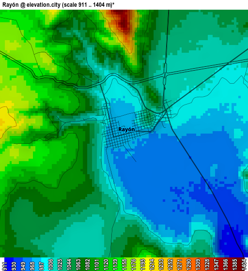
Below is the Elevation map of Rayón, which displays elevation range with different colors. Scale of the first map is from 911 to 1404 m (2989 to 4606 ft) with average elevation of 1044.1 meters (=3426 ft) [note 1]
These maps also provides idea of topography and contour of this city, they are displayed at different zoom levels. More info about maps, scale and edge coordinates you can find below images.
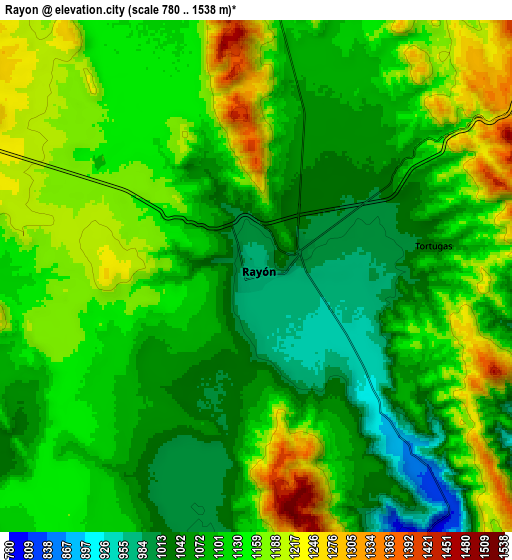
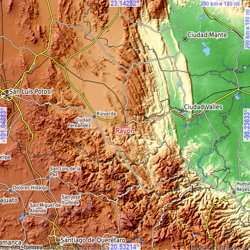
| \ | Map #1 | Map #2 | Topo.Map |
| Scale [m] | 911..1404 m | 780..1538 m | × |
| Scale [ft] | 2989..4606 ft | 2559..5046 ft | × |
| Average | 1044.1 m = 3426 ft | 1114.8 m = 3657 ft | × |
| Width | 9.07 km = 5.6 mi | 18.14 km = 11.3 mi | 290.2 km = 180.3 mi |
| Height | 9.07 km = 5.6 mi | 18.14 km = 11.3 mi | 290.3 km = 180.4 mi |
| ↑Max Latitude | 21.884074° | 21.924847° | 23.14252° |
| Latitude at center | 21.84329° | 21.84329° | 21.84329° |
| ↓Min Latitude | 21.802494° | 21.761686° | 20.53214° |
| ← Min Longitude | -99.686525° | -99.730471° | -101.04883° |
| Longitude center | -99.64258° | -99.64258° | -99.64258° |
| →Max Longitude | -99.598635° | -99.554689° | -98.23633° |
Nearby cities:
Cities around Rayón sort by population:
• Cárdenas elevation 1220 m
17.6 km,  0°
0°
• San Ciro de Acosta 910 m
28.1 km,  220°
220°
• Tamasopo 361 m
27.2 km,  70°
70°
• Agua Buena 366 m
28.6 km,  63°
63°
• San José del Tapanco 905 m
28.6 km,  253°
253°
• Arroyo Seco 999 m
33.2 km,  188°
188°
• Higinio Olivo 1185 m
16.6 km,  23°
23°
• Santa Rita 1043 m
25.9 km,  306°
306°
• Alaquines 1284 m
32.1 km,  7°
7°
• Martinez 1318 m
25 km, 4°
• Lagunillas 933 m
29.2 km,  164°
164°
• Santa Catarina 845 m
25.8 km,  143°
143°
Multilingual:
 En español:
Rayón elevación 973 m.
 En France:
Rayón élévation 973 m.


Sources and notes:
- [note 1] Map square and city borders are not equal. Map elevation data is calculated only from area inside that square.
- [src 1] Elevation data from geonames database provided with same terms of usage.
- [src 2] The elevation map of Rayón is generated using elevation data from NASA's 3 arcsec (90m) resolution SRTM data.
- [src 3] Base (background) map © OpenStreetMap contributors tiles are generated by Geofabrik and OpenTopoMap.
Copyright & License:
This Rayón Elevation Map is licensed under CC BY-SA. You may reuse any part from this page, if you give a proper credit by linking to this URL:
 More info on terms of use page.