San Ciro de Acosta elevation
San Ciro de Acosta (San Luis Potosí), Mexico elevation is 910 meters and San Ciro de Acosta elevation in feet is 2986 ft above sea level [src 1]. San Ciro de Acosta is a seat of a second-order administrative division (feature code) with elevation that is 404 meters (1325 ft) smaller than average city elevation in Mexico.
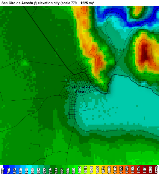
Below is the Elevation map of San Ciro de Acosta, which displays elevation range with different colors. Scale of the first map is from 779 to 1225 m (2556 to 4019 ft) with average elevation of 933.9 meters (=3064 ft) [note 1]
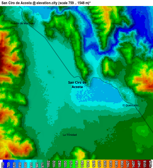
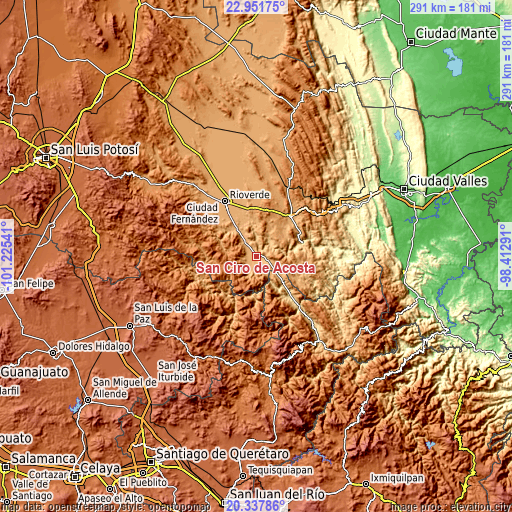
These maps also provides idea of topography and contour of this city, they are displayed at different zoom levels. More info about maps, scale and edge coordinates you can find below images.
| \ | Map #1 | Map #2 | Topo.Map |
| Scale [m] | 779..1225 m | 759..1548 m | × |
| Scale [ft] | 2556..4019 ft | 2490..5079 ft | × |
| Average | 933.9 m = 3064 ft | 1001.4 m = 3285 ft | × |
| Width | 9.08 km = 5.6 mi | 18.17 km = 11.3 mi | 290.6 km = 180.6 mi |
| Height | 9.08 km = 5.6 mi | 18.17 km = 11.3 mi | 290.7 km = 180.6 mi |
| ↑Max Latitude | 21.691559° | 21.732387° | 22.95175° |
| Latitude at center | 21.65072° | 21.65072° | 21.65072° |
| ↓Min Latitude | 21.609869° | 21.569007° | 20.33786° |
| ← Min Longitude | -99.863105° | -99.907051° | -101.22541° |
| Longitude center | -99.81916° | -99.81916° | -99.81916° |
| →Max Longitude | -99.775215° | -99.731269° | -98.41291° |
Nearby cities:
Cities around San Ciro de Acosta sort by population:
• Rioverde elevation 995 m
36.1 km,  329°
329°
• Ciudad Fernández 998 m
37.8 km, 328°
• Rayón 973 m
28.1 km,  40°
40°
• El Capulín 1049 m
30 km,  311°
311°
• El Jabalí 1012 m
35.5 km,  317°
317°
• San José del Tapanco 905 m
16.2 km, 325°
• Arroyo Seco 999 m
17.7 km,  130°
130°
• Concá 570 m
29.7 km,  140°
140°
• Santa Rita 1043 m
36.9 km,  355°
355°
• San Diego 1044 m
41.5 km, 315°
• Lagunillas 933 m
27 km,  104°
104°
• Santa Catarina 845 m
33.5 km,  88°
88°
Multilingual:
 En español:
San Ciro de Acosta elevación 910 m.
 En France:
San Ciro de Acosta élévation 910 m.
 Auf Deutsch:
San Ciro de Acosta höhe über dem Meeresspiegel ist 910 m.
 На русском:
San Ciro de Acosta высота над уровнем моря 910 м
Sources and notes:
- [note 1] Map square and city borders are not equal. Map elevation data is calculated only from area inside that square.
- [src 1] Elevation data from geonames database provided with same terms of usage.
- [src 2] The elevation map of San Ciro de Acosta is generated using elevation data from NASA's 3 arcsec (90m) resolution SRTM data.
- [src 3] Base (background) map © OpenStreetMap contributors tiles are generated by Geofabrik and OpenTopoMap.
Copyright & License:
This San Ciro de Acosta Elevation Map is licensed under CC BY-SA. You may reuse any part from this page, if you give a proper credit by linking to this URL:
 More info on terms of use page.