Ciudad Fernández elevation
Ciudad Fernández (San Luis Potosí), Mexico elevation is 998 meters and Ciudad Fernández elevation in feet is 3274 ft above sea level [src 1]. Ciudad Fernández is a seat of a second-order administrative division (feature code) with elevation that is 316 meters (1037 ft) smaller than average city elevation in Mexico.
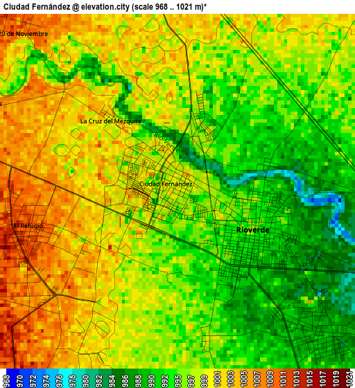
Below is the Elevation map of Ciudad Fernández, which displays elevation range with different colors. Scale of the first map is from 968 to 1021 m (3176 to 3350 ft) with average elevation of 997.1 meters (=3271 ft) [note 1]
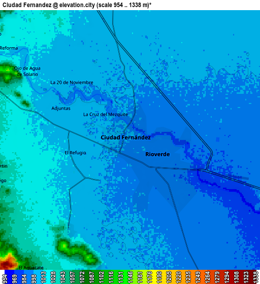
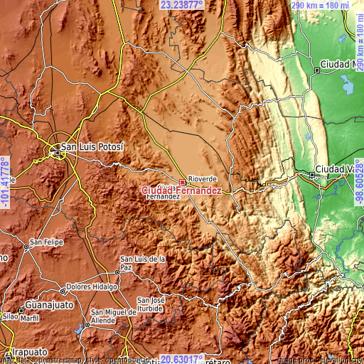
These maps also provides idea of topography and contour of this city, they are displayed at different zoom levels. More info about maps, scale and edge coordinates you can find below images.
| \ | Map #1 | Map #2 | Topo.Map |
| Scale [m] | 968..1021 m | 954..1338 m | × |
| Scale [ft] | 3176..3350 ft | 3130..4390 ft | × |
| Average | 997.1 m = 3271 ft | 1005.8 m = 3300 ft | × |
| Width | 9.06 km = 5.6 mi | 18.13 km = 11.3 mi | 290 km = 180.2 mi |
| Height | 9.06 km = 5.6 mi | 18.13 km = 11.3 mi | 290.1 km = 180.3 mi |
| ↑Max Latitude | 21.981207° | 22.021952° | 23.23877° |
| Latitude at center | 21.94045° | 21.94045° | 21.94045° |
| ↓Min Latitude | 21.899682° | 21.858902° | 20.63017° |
| ← Min Longitude | -100.055475° | -100.099421° | -101.41778° |
| Longitude center | -100.01153° | -100.01153° | -100.01153° |
| →Max Longitude | -99.967585° | -99.923639° | -98.60528° |
Nearby cities:
Cities around Ciudad Fernández sort by population:
• Rioverde elevation 995 m
2 km,  121°
121°
• Progreso 1083 m
34.2 km,  339°
339°
• El Capulín 1049 m
12.8 km,  192°
192°
• El Jabalí 1012 m
7.6 km,  214°
214°
• San José del Tapanco 905 m
21.6 km,  150°
150°
• San Francisco 1023 m
21.6 km,  46°
46°
• Ojo de Agua de Solano 1017 m
8.6 km,  305°
305°
• La Reforma 1023 m
10.7 km, 307°
• Colonia Veinte de Noviembre 1010 m
5.8 km,  317°
317°
• Santa Rita 1043 m
17.9 km,  75°
75°
• San Diego 1044 m
9.6 km,  254°
254°
• Pastora 1022 m
22.2 km,  347°
347°
Multilingual:
 En español:
Ciudad Fernández elevación 998 m.
 En France:
Ciudad Fernández élévation 998 m.
 Auf Deutsch:
Ciudad Fernández höhe über dem Meeresspiegel ist 998 m.

Sources and notes:
- [note 1] Map square and city borders are not equal. Map elevation data is calculated only from area inside that square.
- [src 1] Elevation data from geonames database provided with same terms of usage.
- [src 2] The elevation map of Ciudad Fernández is generated using elevation data from NASA's 3 arcsec (90m) resolution SRTM data.
- [src 3] Base (background) map © OpenStreetMap contributors tiles are generated by Geofabrik and OpenTopoMap.
Copyright & License:
This Ciudad Fernández Elevation Map is licensed under CC BY-SA. You may reuse any part from this page, if you give a proper credit by linking to this URL:
 More info on terms of use page.