Cerritos elevation
Cerritos (San Luis Potosí), Mexico elevation is 1145 meters and Cerritos elevation in feet is 3757 ft above sea level [src 1]. Cerritos is a seat of a second-order administrative division (feature code) with elevation that is 169 meters (554 ft) smaller than average city elevation in Mexico.
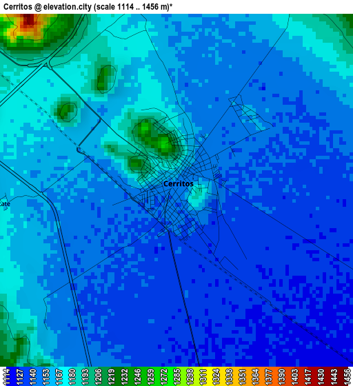
Below is the Elevation map of Cerritos, which displays elevation range with different colors. Scale of the first map is from 1114 to 1456 m (3655 to 4777 ft) with average elevation of 1153.8 meters (=3785 ft) [note 1]
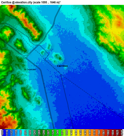
These maps also provides idea of topography and contour of this city, they are displayed at different zoom levels. More info about maps, scale and edge coordinates you can find below images.
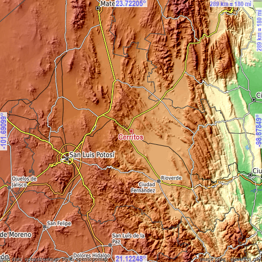
| \ | Map #1 | Map #2 | Topo.Map |
| Scale [m] | 1114..1456 m | 1095..1646 m | × |
| Scale [ft] | 3655..4777 ft | 3593..5400 ft | × |
| Average | 1153.8 m = 3785 ft | 1213.8 m = 3982 ft | × |
| Width | 9.03 km = 5.6 mi | 18.07 km = 11.2 mi | 289 km = 179.6 mi |
| Height | 9.03 km = 5.6 mi | 18.07 km = 11.2 mi | 289.1 km = 179.6 mi |
| ↑Max Latitude | 22.468965° | 22.509569° | 23.72205° |
| Latitude at center | 22.42835° | 22.42835° | 22.42835° |
| ↓Min Latitude | 22.387723° | 22.347084° | 21.12248° |
| ← Min Longitude | -100.328685° | -100.372631° | -101.69099° |
| Longitude center | -100.28474° | -100.28474° | -100.28474° |
| →Max Longitude | -100.240795° | -100.196849° | -98.87849° |
Nearby cities:
Cities around Cerritos sort by population:
• Villa Juárez elevation 1108 m
11.5 km,  170°
170°
• Villa Hidalgo 1675 m
40.5 km,  273°
273°
• Progreso 1083 m
27.5 km,  144°
144°
• Granjenal 1089 m
22.5 km,  100°
100°
• Corcovado 1691 m
42.2 km,  264°
264°
• Palo Seco (El Gato) 1114 m
12.6 km,  130°
130°
• Ojo de Agua 1160 m
19.8 km,  85°
85°
• Guadalcázar 1655 m
24.2 km,  330°
330°
• Peotillos 1511 m
34.3 km,  282°
282°
• Santo Domingo 1092 m
20 km, 143°
• Pastora 1022 m
40.1 km, 144°
• San Nicolás Tolentino 1465 m
34 km,  234°
234°
Multilingual:
 En español:
Cerritos elevación 1145 m.
 En France:
Cerritos élévation 1145 m.
 Auf Deutsch:
Cerritos höhe über dem Meeresspiegel ist 1145 m.

Sources and notes:
- [note 1] Map square and city borders are not equal. Map elevation data is calculated only from area inside that square.
- [src 1] Elevation data from geonames database provided with same terms of usage.
- [src 2] The elevation map of Cerritos is generated using elevation data from NASA's 3 arcsec (90m) resolution SRTM data.
- [src 3] Base (background) map © OpenStreetMap contributors tiles are generated by Geofabrik and OpenTopoMap.
Copyright & License:
This Cerritos Elevation Map is licensed under CC BY-SA. You may reuse any part from this page, if you give a proper credit by linking to this URL:
 More info on terms of use page.