San Nicolás Tolentino elevation
San Nicolás Tolentino (San Luis Potosí), Mexico elevation is 1465 meters and San Nicolás Tolentino elevation in feet is 4806 ft above sea level [src 1]. San Nicolás Tolentino is a seat of a second-order administrative division (feature code) with elevation that is 151 meters (495 ft) bigger than average city elevation in Mexico.
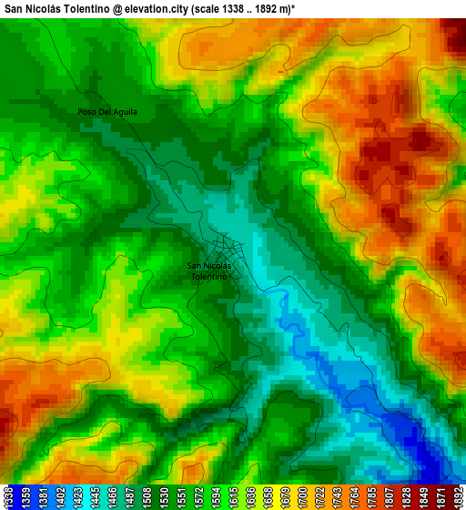
Below is the Elevation map of San Nicolás Tolentino, which displays elevation range with different colors. Scale of the first map is from 1338 to 1892 m (4390 to 6207 ft) with average elevation of 1597.1 meters (=5240 ft) [note 1]
These maps also provides idea of topography and contour of this city, they are displayed at different zoom levels. More info about maps, scale and edge coordinates you can find below images.
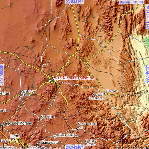
| \ | Map #1 | Topo.Map |
| Scale [m] | 1338..1892 m | × |
| Scale [ft] | 4390..6207 ft | × |
| Average | 1597.1 m = 5240 ft | × |
| Width | 9.04 km = 5.6 mi | 289.4 km = 179.8 mi |
| Height | 9.04 km = 5.6 mi | 289.4 km = 179.8 mi |
| ↑Max Latitude | 22.289648° | 23.54439° |
| Latitude at center | 22.24898° | 22.24898° |
| ↓Min Latitude | 22.208301° | 20.94148° |
| ← Min Longitude | -100.596345° | -101.95865° |
| Longitude center | -100.5524° | -100.5524° |
| →Max Longitude | -100.508455° | -99.14615° |
Nearby cities:
Cities around San Nicolás Tolentino sort by population:
• Cerritos elevation 1145 m
34 km,  54°
54°
• Villa Zaragoza 1977 m
29.9 km,  217°
217°
• Villa Juárez 1108 m
30.6 km,  73°
73°
• Villa Hidalgo 1675 m
25.9 km,  329°
329°
• Laguna de Santa Rita 1842 m
33.8 km,  243°
243°
• Corcovado 1691 m
21.8 km,  318°
318°
• Ciudad Satélite 1907 m
29.4 km, 238°
• Santa Catarina 1214 m
24.3 km,  157°
157°
• Portezuelo 1892 m
29.5 km,  252°
252°
• Peotillos 1511 m
27.9 km,  347°
347°
• Armadillo de los Infante 1632 m
10.7 km,  267°
267°
• Cerro de San Pedro 2040 m
25.7 km,  262°
262°
Multilingual:
 En español:
San Nicolás Tolentino elevación 1465 m.
 En France:
San Nicolás Tolentino élévation 1465 m.
 Auf Deutsch:
San Nicolás Tolentino höhe über dem Meeresspiegel ist 1465 m.
 На русском:
San Nicolás Tolentino высота над уровнем моря 1465 м
Sources and notes:
- [note 1] Map square and city borders are not equal. Map elevation data is calculated only from area inside that square.
- [src 1] Elevation data from geonames database provided with same terms of usage.
- [src 2] The elevation map of San Nicolás Tolentino is generated using elevation data from NASA's 3 arcsec (90m) resolution SRTM data.
- [src 3] Base (background) map © OpenStreetMap contributors tiles are generated by Geofabrik and OpenTopoMap.
Copyright & License:
This San Nicolás Tolentino Elevation Map is licensed under CC BY-SA. You may reuse any part from this page, if you give a proper credit by linking to this URL:
 More info on terms of use page.