Santa Catarina elevation
Santa Catarina (San Luis Potosí, San Nicolás Tolentino), Mexico elevation is 1214 meters and Santa Catarina elevation in feet is 3983 ft above sea level [src 1]. Santa Catarina is a populated place (feature code) with elevation that is 100 meters (328 ft) smaller than average city elevation in Mexico.
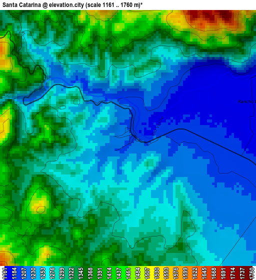
Below is the Elevation map of Santa Catarina, which displays elevation range with different colors. Scale of the first map is from 1161 to 1760 m (3809 to 5774 ft) with average elevation of 1300.2 meters (=4266 ft) [note 1]
These maps also provides idea of topography and contour of this city, they are displayed at different zoom levels. More info about maps, scale and edge coordinates you can find below images.
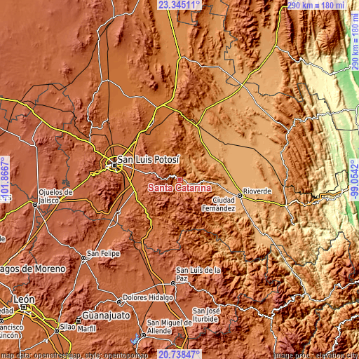
| \ | Map #1 | Topo.Map |
| Scale [m] | 1161..1760 m | × |
| Scale [ft] | 3809..5774 ft | × |
| Average | 1300.2 m = 4266 ft | × |
| Width | 9.06 km = 5.6 mi | 289.8 km = 180.1 mi |
| Height | 9.06 km = 5.6 mi | 289.8 km = 180.1 mi |
| ↑Max Latitude | 22.088516° | 23.34511° |
| Latitude at center | 22.04779° | 22.04779° |
| ↓Min Latitude | 22.007053° | 20.73847° |
| ← Min Longitude | -100.504395° | -101.8667° |
| Longitude center | -100.46045° | -100.46045° |
| →Max Longitude | -100.416505° | -99.0542° |
Nearby cities:
Cities around Santa Catarina sort by population:
• Villa Zaragoza elevation 1977 m
27.9 km,  267°
267°
• Villa Juárez 1108 m
36.8 km,  32°
32°
• Cerro Gordo 1862 m
36.6 km,  257°
257°
• La Esperanza 1921 m
31.7 km, 261°
• Ciudad Satélite 1907 m
35.3 km,  281°
281°
• Enramadas 1817 m
37.9 km,  241°
241°
• Ojo Caliente 1754 m
37.6 km,  233°
233°
• La Reforma 1023 m
38.1 km,  98°
98°
• El Jaralito 1864 m
37.2 km, 268°
• Sánchez 1703 m
37.8 km,  219°
219°
• San Nicolás Tolentino 1465 m
24.3 km,  337°
337°
• Armadillo de los Infante 1632 m
29.8 km,  317°
317°
Multilingual:
 En español:
Santa Catarina elevación 1214 m.
 En France:
Santa Catarina élévation 1214 m.
 Auf Deutsch:
Santa Catarina höhe über dem Meeresspiegel ist 1214 m.

Sources and notes:
- [note 1] Map square and city borders are not equal. Map elevation data is calculated only from area inside that square.
- [src 1] Elevation data from geonames database provided with same terms of usage.
- [src 2] The elevation map of Santa Catarina is generated using elevation data from NASA's 3 arcsec (90m) resolution SRTM data.
- [src 3] Base (background) map © OpenStreetMap contributors tiles are generated by Geofabrik and OpenTopoMap.
Copyright & License:
This Santa Catarina Elevation Map is licensed under CC BY-SA. You may reuse any part from this page, if you give a proper credit by linking to this URL:
 More info on terms of use page.