Sánchez elevation
Sánchez (San Luis Potosí, Santa María del Río), Mexico elevation is 1703 meters and Sánchez elevation in feet is 5587 ft above sea level [src 1]. Sánchez is a populated place (feature code) with elevation that is 389 meters (1276 ft) bigger than average city elevation in Mexico.
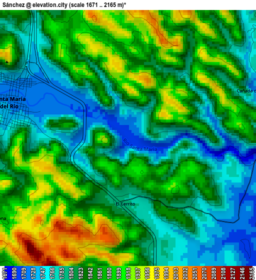
Below is the Elevation map of Sánchez, which displays elevation range with different colors. Scale of the first map is from 1671 to 2165 m (5482 to 7103 ft) with average elevation of 1839.3 meters (=6034 ft) [note 1]
These maps also provides idea of topography and contour of this city, they are displayed at different zoom levels. More info about maps, scale and edge coordinates you can find below images.
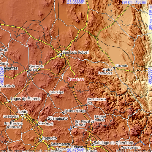
| \ | Map #1 | Topo.Map |
| Scale [m] | 1671..2165 m | × |
| Scale [ft] | 5482..7103 ft | × |
| Average | 1839.3 m = 6034 ft | × |
| Width | 9.07 km = 5.6 mi | 290.4 km = 180.4 mi |
| Height | 9.07 km = 5.6 mi | 290.4 km = 180.4 mi |
| ↑Max Latitude | 21.82789° | 23.08685° |
| Latitude at center | 21.78709° | 21.78709° |
| ↓Min Latitude | 21.746278° | 20.47544° |
| ← Min Longitude | -100.740095° | -102.1024° |
| Longitude center | -100.69615° | -100.69615° |
| →Max Longitude | -100.652205° | -99.2899° |
Nearby cities:
Cities around Sánchez sort by population:
• Santa María del Río elevation 1736 m
4.5 km,  283°
283°
• Tierra Nueva 1788 m
18.3 km,  135°
135°
• Laguna de San Vicente 1820 m
24.4 km,  316°
316°
• Pardo 1794 m
19.7 km,  303°
303°
• Cerro Gordo 1862 m
23.7 km,  331°
331°
• El Fuerte 1748 m
8.9 km,  158°
158°
• Socavón (El Carmen) 1810 m
19.5 km,  291°
291°
• Ejido Gogorrón (Ex-Hacienda de Gogorrón) 1807 m
23 km, 284°
• Enramadas 1817 m
13.9 km, 320°
• Ojo Caliente 1754 m
8.9 km, 318°
• Ejido la Pitahaya (Santo Domingo) 1883 m
21.2 km,  198°
198°
• Yerbabuena 1861 m
13.4 km,  213°
213°
Multilingual:
 En español:
Sánchez elevación 1703 m.
 En France:
Sánchez élévation 1703 m.
 Auf Deutsch:
Sánchez höhe über dem Meeresspiegel ist 1703 m.

Sources and notes:
- [note 1] Map square and city borders are not equal. Map elevation data is calculated only from area inside that square.
- [src 1] Elevation data from geonames database provided with same terms of usage.
- [src 2] The elevation map of Sánchez is generated using elevation data from NASA's 3 arcsec (90m) resolution SRTM data.
- [src 3] Base (background) map © OpenStreetMap contributors tiles are generated by Geofabrik and OpenTopoMap.
Copyright & License:
This Sánchez Elevation Map is licensed under CC BY-SA. You may reuse any part from this page, if you give a proper credit by linking to this URL:
 More info on terms of use page.