Santa María del Río elevation
Santa María del Río (San Luis Potosí), Mexico elevation is 1736 meters and Santa María del Río elevation in feet is 5696 ft above sea level [src 1]. Santa María del Río is a seat of a second-order administrative division (feature code) with elevation that is 422 meters (1385 ft) bigger than average city elevation in Mexico.
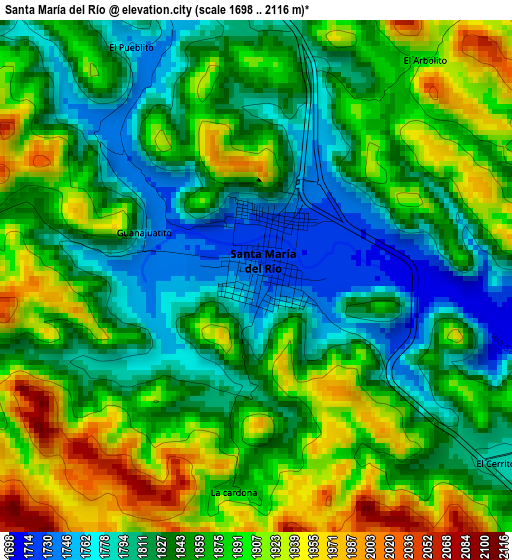
Below is the Elevation map of Santa María del Río, which displays elevation range with different colors. Scale of the first map is from 1698 to 2116 m (5571 to 6942 ft) with average elevation of 1858.3 meters (=6097 ft) [note 1]
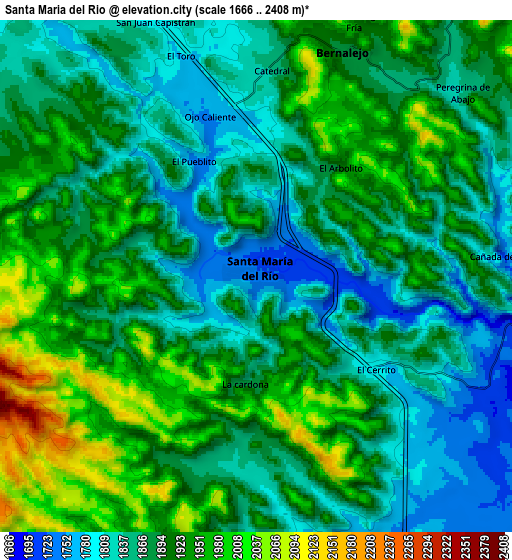
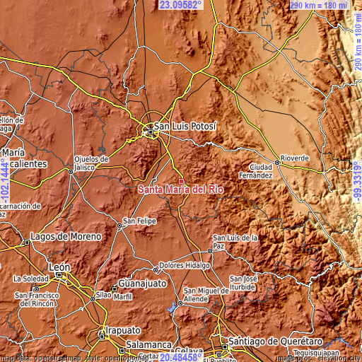
These maps also provides idea of topography and contour of this city, they are displayed at different zoom levels. More info about maps, scale and edge coordinates you can find below images.
| \ | Map #1 | Map #2 | Topo.Map |
| Scale [m] | 1698..2116 m | 1666..2408 m | × |
| Scale [ft] | 5571..6942 ft | 5466..7900 ft | × |
| Average | 1858.3 m = 6097 ft | 1893.4 m = 6212 ft | × |
| Width | 9.07 km = 5.6 mi | 18.15 km = 11.3 mi | 290.3 km = 180.4 mi |
| Height | 9.07 km = 5.6 mi | 18.15 km = 11.3 mi | 290.4 km = 180.4 mi |
| ↑Max Latitude | 21.836948° | 21.877734° | 23.09582° |
| Latitude at center | 21.79615° | 21.79615° | 21.79615° |
| ↓Min Latitude | 21.75534° | 21.714519° | 20.48458° |
| ← Min Longitude | -100.782095° | -100.826041° | -102.1444° |
| Longitude center | -100.73815° | -100.73815° | -100.73815° |
| →Max Longitude | -100.694205° | -100.650259° | -99.3319° |
Nearby cities:
Cities around Santa María del Río sort by population:
• Villa de Reyes elevation 1815 m
20.3 km,  272°
272°
• El Rosario 1873 m
20.6 km,  250°
250°
• Laguna de San Vicente 1820 m
20.8 km,  323°
323°
• Pardo 1794 m
15.6 km,  308°
308°
• Cerro Gordo 1862 m
21 km,  340°
340°
• El Fuerte 1748 m
12 km,  140°
140°
• Socavón (El Carmen) 1810 m
15.1 km,  293°
293°
• Ejido Gogorrón (Ex-Hacienda de Gogorrón) 1807 m
18.5 km, 285°
• Enramadas 1817 m
10.7 km,  334°
334°
• Ojo Caliente 1754 m
5.9 km, 344°
• Yerbabuena 1861 m
12.6 km,  193°
193°
• Sánchez 1703 m
4.5 km,  103°
103°
Multilingual:
 En español:
Santa María del Río elevación 1736 m.
 En France:
Santa María del Río élévation 1736 m.
 Auf Deutsch:
Santa María del Río höhe über dem Meeresspiegel ist 1736 m.
 На русском:
Santa María del Río высота над уровнем моря 1736 м
Sources and notes:
- [note 1] Map square and city borders are not equal. Map elevation data is calculated only from area inside that square.
- [src 1] Elevation data from geonames database provided with same terms of usage.
- [src 2] The elevation map of Santa María del Río is generated using elevation data from NASA's 3 arcsec (90m) resolution SRTM data.
- [src 3] Base (background) map © OpenStreetMap contributors tiles are generated by Geofabrik and OpenTopoMap.
Copyright & License:
This Santa María del Río Elevation Map is licensed under CC BY-SA. You may reuse any part from this page, if you give a proper credit by linking to this URL:
 More info on terms of use page.