Imaichi elevation
Imaichi (Tochigi, Nikko-shi), Japan elevation is 391 meters and Imaichi elevation in feet is 1283 ft above sea level [src 1]. Imaichi is a populated place (feature code) with elevation that is 306 meters (1004 ft) bigger than average city elevation in Japan.
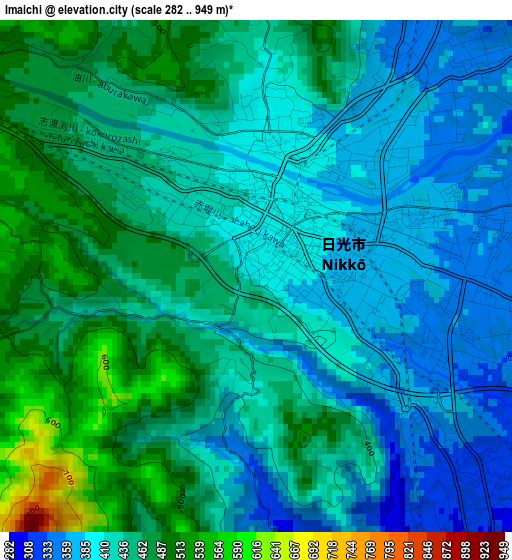
Below is the Elevation map of Imaichi, which displays elevation range with different colors. Scale of the first map is from 282 to 949 m (925 to 3114 ft) with average elevation of 430.6 meters (=1413 ft) [note 1]
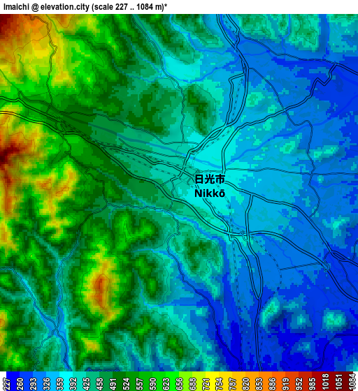
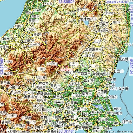
These maps also provides idea of topography and contour of this city, they are displayed at different zoom levels. More info about maps, scale and edge coordinates you can find below images.
| \ | Map #1 | Map #2 | Topo.Map |
| Scale [m] | 282..949 m | 227..1084 m | × |
| Scale [ft] | 925..3114 ft | 745..3556 ft | × |
| Average | 430.6 m = 1413 ft | 441.4 m = 1448 ft | × |
| Width | 7.83 km = 4.9 mi | 15.67 km = 9.7 mi | 250.7 km = 155.8 mi |
| Height | 7.83 km = 4.9 mi | 15.67 km = 9.7 mi | 250.7 km = 155.8 mi |
| ↑Max Latitude | 36.751889° | 36.787091° | 37.83562° |
| Latitude at center | 36.71667° | 36.71667° | 36.71667° |
| ↓Min Latitude | 36.681435° | 36.646184° | 35.58118° |
| ← Min Longitude | 139.639385° | 139.595439° | 138.27708° |
| Longitude center | 139.68333° | 139.68333° | 139.68333° |
| →Max Longitude | 139.727275° | 139.771221° | 141.08958° |
Nearby cities:
Cities around Imaichi sort by population:
• Utsunomiya elevation 137 m
24.4 km,  133°
133°
• Kanuma 162 m
19.1 km,  166°
166°
• Tochigi 51 m
37.3 km, 173°
• Ōtawara 205 m
35.3 km,  61°
61°
• Mibu 59 m
34.9 km,  162°
162°
• Yaita 191 m
24.1 km,  67°
67°
• Kaminokawa 65 m
37.8 km,  146°
146°
• Ujiie 164 m
25.5 km,  98°
98°
• Tanuma 66 m
39.9 km,  192°
192°
• Nikkō 555 m
7 km,  301°
301°
• Shimotsuke 66 m
37.5 km, 154°
• Sakura 190 m
27.1 km,  89°
89°
Multilingual:
 En español:
Imaichi elevación 391 m.
 En France:
Imaichi élévation 391 m.


Sources and notes:
- [note 1] Map square and city borders are not equal. Map elevation data is calculated only from area inside that square.
- [src 1] Elevation data from geonames database provided with same terms of usage.
- [src 2] The elevation map of Imaichi is generated using elevation data from NASA's 3 arcsec (90m) resolution SRTM data.
- [src 3] Base (background) map © OpenStreetMap contributors tiles are generated by Geofabrik and OpenTopoMap.
Copyright & License:
This Imaichi Elevation Map is licensed under CC BY-SA. You may reuse any part from this page, if you give a proper credit by linking to this URL:
 More info on terms of use page.