Mibu elevation
Mibu (Tochigi, Shimotsuga-gun), Japan elevation is 59 meters and Mibu elevation in feet is 194 ft above sea level [src 1]. Mibu is a populated place (feature code) with elevation that is 26 meters (85 ft) smaller than average city elevation in Japan.
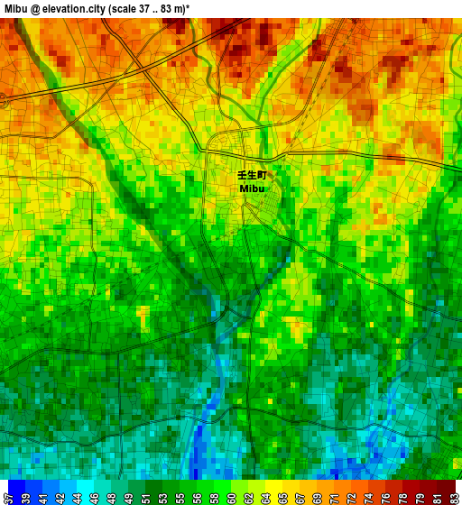
Below is the Elevation map of Mibu, which displays elevation range with different colors. Scale of the first map is from 37 to 83 m (121 to 272 ft) with average elevation of 59 meters (=194 ft) [note 1]
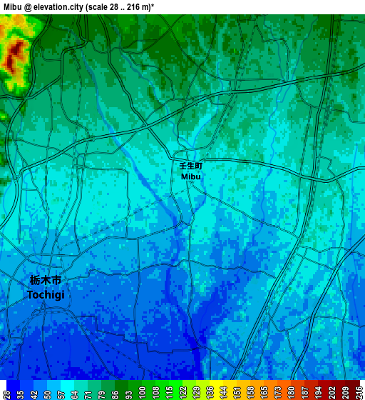
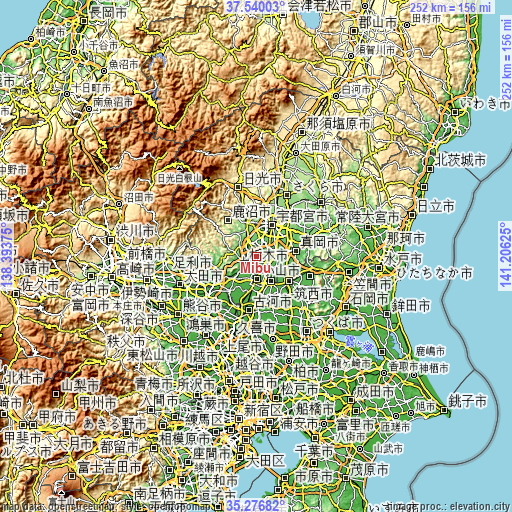
These maps also provides idea of topography and contour of this city, they are displayed at different zoom levels. More info about maps, scale and edge coordinates you can find below images.
| \ | Map #1 | Map #2 | Topo.Map |
| Scale [m] | 37..83 m | 28..216 m | × |
| Scale [ft] | 121..272 ft | 92..709 ft | × |
| Average | 59 m = 194 ft | 63.1 m = 207 ft | × |
| Width | 7.86 km = 4.9 mi | 15.73 km = 9.8 mi | 251.6 km = 156.3 mi |
| Height | 7.86 km = 4.9 mi | 15.73 km = 9.8 mi | 251.6 km = 156.3 mi |
| ↑Max Latitude | 36.452026° | 36.487365° | 37.54003° |
| Latitude at center | 36.41667° | 36.41667° | 36.41667° |
| ↓Min Latitude | 36.381298° | 36.34591° | 35.27682° |
| ← Min Longitude | 139.756055° | 139.712109° | 138.39375° |
| Longitude center | 139.8° | 139.8° | 139.8° |
| →Max Longitude | 139.843945° | 139.887891° | 141.20625° |
Nearby cities:
Cities around Mibu sort by population:
• Utsunomiya elevation 137 m
18.3 km,  24°
24°
• Oyama 41 m
13 km,  180°
180°
• Kanuma 162 m
16 km,  338°
338°
• Sano 36 m
22.4 km,  240°
240°
• Tochigi 51 m
7 km, 238°
• Mooka 67 m
19.5 km,  84°
84°
• Shimodate 34 m
20.9 km,  128°
128°
• Yūki 40 m
15 km,  150°
150°
• Kaminokawa 65 m
10.6 km, 79°
• Tanuma 66 m
20.2 km,  254°
254°
• Chikusei 33 m
19.8 km,  124°
124°
• Shimotsuke 66 m
5.9 km,  93°
93°
Multilingual:
 En español:
Mibu elevación 59 m.
 En France:
Mibu élévation 59 m.


Sources and notes:
- [note 1] Map square and city borders are not equal. Map elevation data is calculated only from area inside that square.
- [src 1] Elevation data from geonames database provided with same terms of usage.
- [src 2] The elevation map of Mibu is generated using elevation data from NASA's 3 arcsec (90m) resolution SRTM data.
- [src 3] Base (background) map © OpenStreetMap contributors tiles are generated by Geofabrik and OpenTopoMap.
Copyright & License:
This Mibu Elevation Map is licensed under CC BY-SA. You may reuse any part from this page, if you give a proper credit by linking to this URL:
 More info on terms of use page.