Utsunomiya elevation
Utsunomiya (Tochigi, Utsunomiya-shi), Japan elevation is 137 meters and Utsunomiya elevation in feet is 449 ft above sea level [src 1]. Utsunomiya is a seat of a first-order administrative division (feature code) with elevation that is 52 meters (171 ft) bigger than average city elevation in Japan.
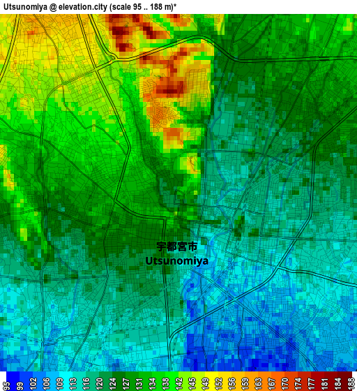
Below is the Elevation map of Utsunomiya, which displays elevation range with different colors. Scale of the first map is from 95 to 188 m (312 to 617 ft) with average elevation of 126 meters (=413 ft) [note 1]
These maps also provides idea of topography and contour of this city, they are displayed at different zoom levels. More info about maps, scale and edge coordinates you can find below images.
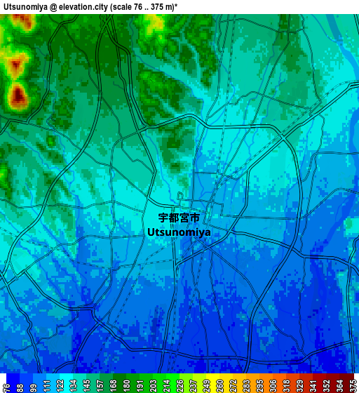
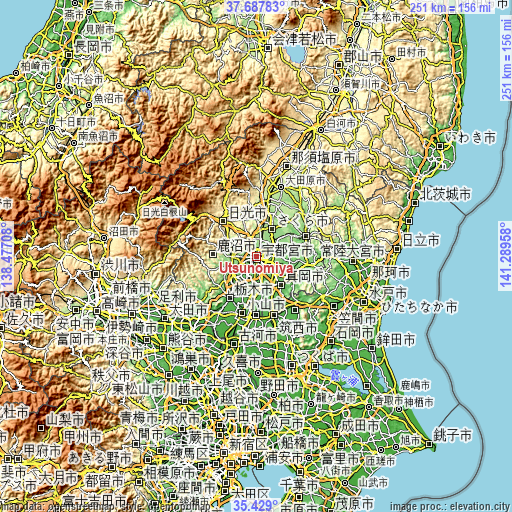
| \ | Map #1 | Map #2 | Topo.Map |
| Scale [m] | 95..188 m | 76..375 m | × |
| Scale [ft] | 312..617 ft | 249..1230 ft | × |
| Average | 126 m = 413 ft | 129.6 m = 425 ft | × |
| Width | 7.85 km = 4.9 mi | 15.7 km = 9.8 mi | 251.2 km = 156.1 mi |
| Height | 7.85 km = 4.9 mi | 15.7 km = 9.8 mi | 251.2 km = 156.1 mi |
| ↑Max Latitude | 36.601957° | 36.637228° | 37.68783° |
| Latitude at center | 36.56667° | 36.56667° | 36.56667° |
| ↓Min Latitude | 36.531367° | 36.496047° | 35.429° |
| ← Min Longitude | 139.839385° | 139.795439° | 138.47708° |
| Longitude center | 139.88333° | 139.88333° | 139.88333° |
| →Max Longitude | 139.927275° | 139.971221° | 141.28958° |
Nearby cities:
Cities around Utsunomiya sort by population:
• Kanuma elevation 162 m
13.5 km,  262°
262°
• Tochigi 51 m
24.4 km,  213°
213°
• Mooka 67 m
19 km,  141°
141°
• Imaichi 391 m
24.4 km,  313°
313°
• Mibu 59 m
18.3 km,  204°
204°
• Yaita 191 m
26.3 km,  9°
9°
• Kaminokawa 65 m
15.1 km,  168°
168°
• Ujiie 164 m
15 km,  29°
29°
• Mashiko 79 m
22.3 km,  119°
119°
• Karasuyama 119 m
25.5 km,  68°
68°
• Sakura 190 m
19.5 km, 28°
• Shimotsuke 66 m
17.1 km,  185°
185°
Multilingual:
 En español:
Utsunomiya elevación 137 m.
 En France:
Utsunomiya élévation 137 m.
 Auf Deutsch:
Utsunomiya höhe über dem Meeresspiegel ist 137 m.

Sources and notes:
- [note 1] Map square and city borders are not equal. Map elevation data is calculated only from area inside that square.
- [src 1] Elevation data from geonames database provided with same terms of usage.
- [src 2] The elevation map of Utsunomiya is generated using elevation data from NASA's 3 arcsec (90m) resolution SRTM data.
- [src 3] Base (background) map © OpenStreetMap contributors tiles are generated by Geofabrik and OpenTopoMap.
Copyright & License:
This Utsunomiya Elevation Map is licensed under CC BY-SA. You may reuse any part from this page, if you give a proper credit by linking to this URL:
 More info on terms of use page.