Ujiie elevation
Ujiie (Tochigi, Sakura-shi), Japan elevation is 164 meters and Ujiie elevation in feet is 538 ft above sea level [src 1]. Ujiie is a populated place (feature code) with elevation that is 79 meters (259 ft) bigger than average city elevation in Japan.
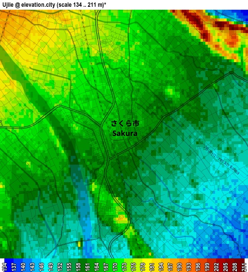
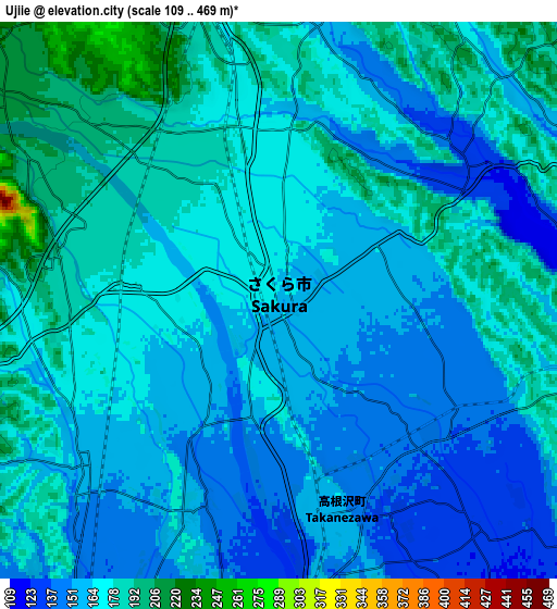
Below is the Elevation map of Ujiie, which displays elevation range with different colors. Scale of the first map is from 134 to 211 m (440 to 692 ft) with average elevation of 162.4 meters (=533 ft) [note 1]
These maps also provides idea of topography and contour of this city, they are displayed at different zoom levels. More info about maps, scale and edge coordinates you can find below images.
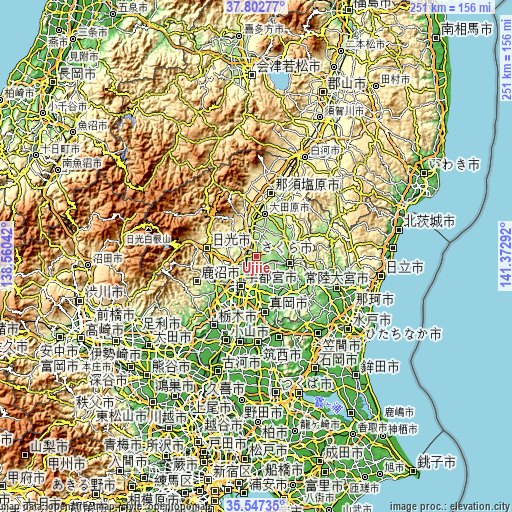
| \ | Map #1 | Map #2 | Topo.Map |
| Scale [m] | 134..211 m | 109..469 m | × |
| Scale [ft] | 440..692 ft | 358..1539 ft | × |
| Average | 162.4 m = 533 ft | 167.4 m = 549 ft | × |
| Width | 7.84 km = 4.9 mi | 15.67 km = 9.7 mi | 250.8 km = 155.8 mi |
| Height | 7.84 km = 4.9 mi | 15.67 km = 9.7 mi | 250.8 km = 155.8 mi |
| ↑Max Latitude | 36.718564° | 36.753782° | 37.80277° |
| Latitude at center | 36.68333° | 36.68333° | 36.68333° |
| ↓Min Latitude | 36.64808° | 36.612814° | 35.54735° |
| ← Min Longitude | 139.922725° | 139.878779° | 138.56042° |
| Longitude center | 139.96667° | 139.96667° | 139.96667° |
| →Max Longitude | 140.010615° | 140.054561° | 141.37292° |
Nearby cities:
Cities around Ujiie sort by population:
• Utsunomiya elevation 137 m
15 km,  209°
209°
• Kanuma 162 m
25.6 km,  234°
234°
• Mooka 67 m
28.2 km,  170°
170°
• Imaichi 391 m
25.5 km,  278°
278°
• Ōtawara 205 m
21.2 km,  16°
16°
• Yaita 191 m
13.3 km,  347°
347°
• Kaminokawa 65 m
28.2 km,  189°
189°
• Mashiko 79 m
26.9 km,  153°
153°
• Motegi 105 m
26.8 km,  133°
133°
• Karasuyama 119 m
16.8 km,  102°
102°
• Nasukarasuyama 89 m
17.7 km, 101°
• Sakura 190 m
4.6 km, 24°
Multilingual:
 En español:
Ujiie elevación 164 m.
 En France:
Ujiie élévation 164 m.


Sources and notes:
- [note 1] Map square and city borders are not equal. Map elevation data is calculated only from area inside that square.
- [src 1] Elevation data from geonames database provided with same terms of usage.
- [src 2] The elevation map of Ujiie is generated using elevation data from NASA's 3 arcsec (90m) resolution SRTM data.
- [src 3] Base (background) map © OpenStreetMap contributors tiles are generated by Geofabrik and OpenTopoMap.
Copyright & License:
This Ujiie Elevation Map is licensed under CC BY-SA. You may reuse any part from this page, if you give a proper credit by linking to this URL:
 More info on terms of use page.