Ōtawara elevation
Ōtawara (Tochigi, Ōtawara-shi), Japan elevation is 205 meters and Ōtawara elevation in feet is 673 ft above sea level [src 1]. Ōtawara is a seat of a second-order administrative division (feature code) with elevation that is 120 meters (394 ft) bigger than average city elevation in Japan.
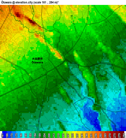
Below is the Elevation map of Ōtawara, which displays elevation range with different colors. Scale of the first map is from 161 to 284 m (528 to 932 ft) with average elevation of 208.8 meters (=685 ft) [note 1]
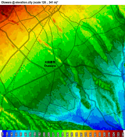
These maps also provides idea of topography and contour of this city, they are displayed at different zoom levels. More info about maps, scale and edge coordinates you can find below images.
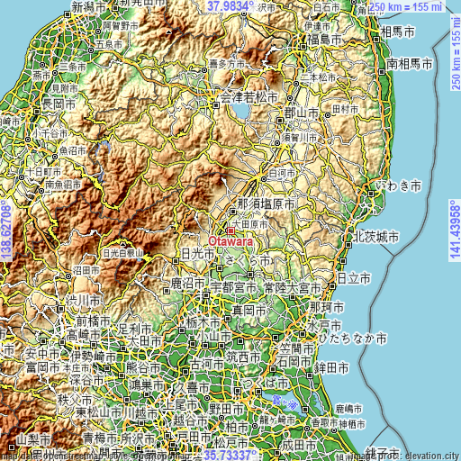
| \ | Map #1 | Map #2 | Topo.Map |
| Scale [m] | 161..284 m | 126..341 m | × |
| Scale [ft] | 528..932 ft | 413..1119 ft | × |
| Average | 208.8 m = 685 ft | 214.7 m = 704 ft | × |
| Width | 7.82 km = 4.9 mi | 15.64 km = 9.7 mi | 250.2 km = 155.5 mi |
| Height | 7.82 km = 4.9 mi | 15.64 km = 9.7 mi | 250.2 km = 155.5 mi |
| ↑Max Latitude | 36.90182° | 36.936953° | 37.9834° |
| Latitude at center | 36.86667° | 36.86667° | 36.86667° |
| ↓Min Latitude | 36.831504° | 36.796322° | 35.73337° |
| ← Min Longitude | 139.989385° | 139.945439° | 138.62708° |
| Longitude center | 140.03333° | 140.03333° | 140.03333° |
| →Max Longitude | 140.077275° | 140.121221° | 141.43958° |
Nearby cities:
Cities around Ōtawara sort by population:
• Utsunomiya elevation 137 m
35.9 km,  201°
201°
• Imaichi 391 m
35.3 km,  241°
241°
• Kuroiso 301 m
11.2 km,  7°
7°
• Yaita 191 m
11.6 km,  230°
230°
• Ujiie 164 m
21.2 km, 196°
• Daigo 195 m
30.3 km,  111°
111°
• Karasuyama 119 m
26.2 km,  156°
156°
• Nikkō 555 m
39.3 km,  250°
250°
• Shirakawa 323 m
34.7 km,  35°
35°
• Nasukarasuyama 89 m
26.4 km,  154°
154°
• Sakura 190 m
16.7 km,  194°
194°
• Nasushiobara 357 m
13 km,  344°
344°
Multilingual:
 En español:
Ōtawara elevación 205 m.
 En France:
Ōtawara élévation 205 m.


Sources and notes:
- [note 1] Map square and city borders are not equal. Map elevation data is calculated only from area inside that square.
- [src 1] Elevation data from geonames database provided with same terms of usage.
- [src 2] The elevation map of Ōtawara is generated using elevation data from NASA's 3 arcsec (90m) resolution SRTM data.
- [src 3] Base (background) map © OpenStreetMap contributors tiles are generated by Geofabrik and OpenTopoMap.
Copyright & License:
This Ōtawara Elevation Map is licensed under CC BY-SA. You may reuse any part from this page, if you give a proper credit by linking to this URL:
 More info on terms of use page.