Mitake elevation
Mitake (Gifu, Kani-gun), Japan elevation is 232 meters and Mitake elevation in feet is 761 ft above sea level [src 1]. Mitake is a populated place (feature code) with elevation that is 147 meters (482 ft) bigger than average city elevation in Japan.
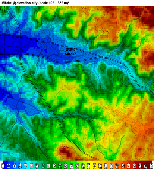
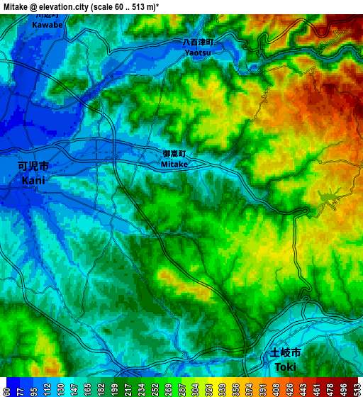
Below is the Elevation map of Mitake, which displays elevation range with different colors. Scale of the first map is from 102 to 382 m (335 to 1253 ft) with average elevation of 213.3 meters (=700 ft) [note 1]
These maps also provides idea of topography and contour of this city, they are displayed at different zoom levels. More info about maps, scale and edge coordinates you can find below images.
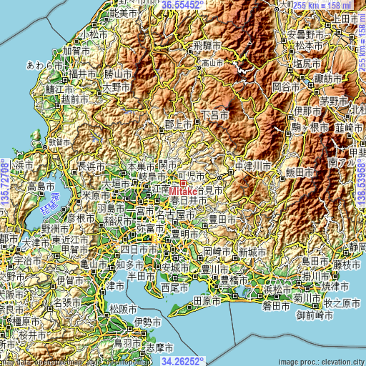
| \ | Map #1 | Map #2 | Topo.Map |
| Scale [m] | 102..382 m | 60..513 m | × |
| Scale [ft] | 335..1253 ft | 197..1683 ft | × |
| Average | 213.3 m = 700 ft | 213.5 m = 700 ft | × |
| Width | 7.96 km = 4.9 mi | 15.93 km = 9.9 mi | 254.8 km = 158.3 mi |
| Height | 7.96 km = 4.9 mi | 15.93 km = 9.9 mi | 254.8 km = 158.3 mi |
| ↑Max Latitude | 35.452476° | 35.488265° | 36.55452° |
| Latitude at center | 35.41667° | 35.41667° | 35.41667° |
| ↓Min Latitude | 35.380848° | 35.345011° | 34.26252° |
| ← Min Longitude | 137.089385° | 137.045439° | 135.72708° |
| Longitude center | 137.13333° | 137.13333° | 137.13333° |
| →Max Longitude | 137.177275° | 137.221221° | 138.53958° |
Nearby cities:
Cities around Mitake sort by population:
• Kasugai elevation 30 m
23.8 km,  217°
217°
• Seto 111 m
20.6 km,  188°
188°
• Kakamigahara 40 m
24.2 km,  270°
270°
• Tajimi 138 m
11.1 km,  180°
180°
• Inuyama 56 m
17.7 km,  256°
256°
• Toki 159 m
8.7 km,  148°
148°
• Minokamo 175 m
12.5 km,  305°
305°
• Mizunami 157 m
11.9 km,  117°
117°
• Mino 232 m
23.5 km,  303°
303°
• Ena 358 m
22.9 km,  81°
81°
• Sekimachi 51 m
21 km,  290°
290°
• Kani 123 m
7.1 km, 258°
Multilingual:
 En español:
Mitake elevación 232 m.
 En France:
Mitake élévation 232 m.


Sources and notes:
- [note 1] Map square and city borders are not equal. Map elevation data is calculated only from area inside that square.
- [src 1] Elevation data from geonames database provided with same terms of usage.
- [src 2] The elevation map of Mitake is generated using elevation data from NASA's 3 arcsec (90m) resolution SRTM data.
- [src 3] Base (background) map © OpenStreetMap contributors tiles are generated by Geofabrik and OpenTopoMap.
Copyright & License:
This Mitake Elevation Map is licensed under CC BY-SA. You may reuse any part from this page, if you give a proper credit by linking to this URL:
 More info on terms of use page.