Frossasco elevation
Frossasco (Piedmont, Torino), Italy elevation is 321 meters and Frossasco elevation in feet is 1053 ft above sea level [src 1]. Frossasco is a seat of a third-order administrative division (feature code) with elevation that is 1 meters (3 ft) smaller than average city elevation in Italy.
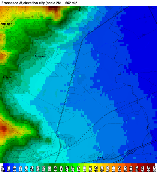
Below is the Elevation map of Frossasco, which displays elevation range with different colors. Scale of the first map is from 281 to 662 m (922 to 2172 ft) with average elevation of 347.4 meters (=1140 ft) [note 1]
These maps also provides idea of topography and contour of this city, they are displayed at different zoom levels. More info about maps, scale and edge coordinates you can find below images.
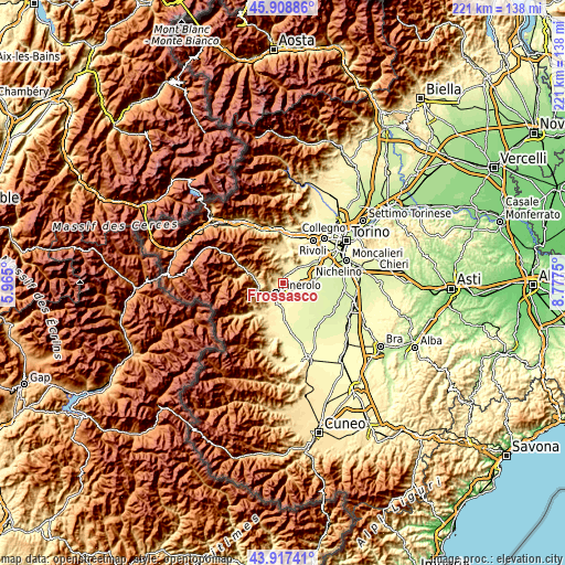
| \ | Map #1 | Topo.Map |
| Scale [m] | 281..662 m | × |
| Scale [ft] | 922..2172 ft | × |
| Average | 347.4 m = 1140 ft | × |
| Width | 6.92 km = 4.3 mi | 221.4 km = 137.6 mi |
| Height | 6.92 km = 4.3 mi | 221.4 km = 137.6 mi |
| ↑Max Latitude | 44.952868° | 45.90886° |
| Latitude at center | 44.92176° | 44.92176° |
| ↓Min Latitude | 44.890635° | 43.91741° |
| ← Min Longitude | 7.327305° | 5.965° |
| Longitude center | 7.37125° | 7.37125° |
| →Max Longitude | 7.415195° | 8.7775° |
Nearby cities:
Cities around Frossasco sort by population:
• Pinerolo elevation 379 m
5.1 km,  217°
217°
• Cumiana 351 m
6.1 km,  4°
4°
• Airasca 260 m
8.8 km,  93°
93°
• Piscina 286 m
4.3 km, 94°
• Cantalupa 498 m
4.2 km,  309°
309°
• Riva 325 m
3.4 km,  165°
165°
• San Secondo di Pinerolo 420 m
8.4 km, 223°
• San Pietro Val Lemina 460 m
5 km,  250°
250°
• Buriasco 300 m
6.4 km,  149°
149°
• Roletto 401 m
3.1 km,  275°
275°
• Osasco 346 m
8.3 km,  195°
195°
• Macello 306 m
8.1 km,  164°
164°
Multilingual:
 En español:
Frossasco elevación 321 m.
 En France:
Frossasco élévation 321 m.
 Auf Deutsch:
Frossasco höhe über dem Meeresspiegel ist 321 m.

Sources and notes:
- [note 1] Map square and city borders are not equal. Map elevation data is calculated only from area inside that square.
- [src 1] Elevation data from geonames database provided with same terms of usage.
- [src 2] The elevation map of Frossasco is generated using elevation data from NASA's 3 arcsec (90m) resolution SRTM data.
- [src 3] Base (background) map © OpenStreetMap contributors tiles are generated by Geofabrik and OpenTopoMap.
Copyright & License:
This Frossasco Elevation Map is licensed under CC BY-SA. You may reuse any part from this page, if you give a proper credit by linking to this URL:
 More info on terms of use page.