Macello elevation
Macello (Piedmont, Torino), Italy elevation is 306 meters and Macello elevation in feet is 1004 ft above sea level [src 1]. Macello is a seat of a third-order administrative division (feature code) with elevation that is 16 meters (52 ft) smaller than average city elevation in Italy.
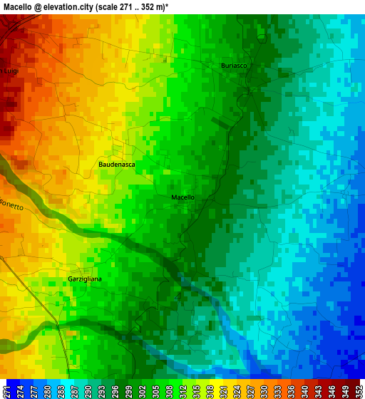
Below is the Elevation map of Macello, which displays elevation range with different colors. Scale of the first map is from 271 to 352 m (889 to 1155 ft) with average elevation of 303.5 meters (=996 ft) [note 1]
These maps also provides idea of topography and contour of this city, they are displayed at different zoom levels. More info about maps, scale and edge coordinates you can find below images.
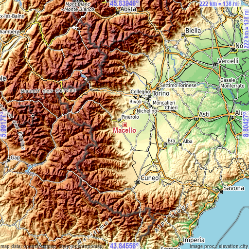
| \ | Map #1 | Topo.Map |
| Scale [m] | 271..352 m | × |
| Scale [ft] | 889..1155 ft | × |
| Average | 303.5 m = 996 ft | × |
| Width | 6.93 km = 4.3 mi | 221.7 km = 137.8 mi |
| Height | 6.93 km = 4.3 mi | 221.7 km = 137.8 mi |
| ↑Max Latitude | 44.882286° | 45.83946° |
| Latitude at center | 44.85114° | 44.85114° |
| ↓Min Latitude | 44.819977° | 43.84556° |
| ← Min Longitude | 7.354075° | 5.99177° |
| Longitude center | 7.39802° | 7.39802° |
| →Max Longitude | 7.441965° | 8.80427° |
Nearby cities:
Cities around Macello sort by population:
• Pinerolo elevation 379 m
6.5 km,  305°
305°
• Vigone 259 m
7.9 km,  97°
97°
• Cavour 307 m
6.7 km,  196°
196°
• Piscina 286 m
7.8 km,  15°
15°
• Bricherasio 389 m
8.1 km,  247°
247°
• Cercenasco 259 m
8 km,  81°
81°
• Riva 325 m
4.8 km,  344°
344°
• San Secondo di Pinerolo 420 m
8 km,  282°
282°
• Buriasco 300 m
2.6 km,  25°
25°
• Osasco 346 m
4.3 km,  267°
267°
• Campiglione 365 m
7.9 km,  227°
227°
• Garzigliana 315 m
2.4 km, 230°
Multilingual:
 En español:
Macello elevación 306 m.
 En France:
Macello élévation 306 m.


Sources and notes:
- [note 1] Map square and city borders are not equal. Map elevation data is calculated only from area inside that square.
- [src 1] Elevation data from geonames database provided with same terms of usage.
- [src 2] The elevation map of Macello is generated using elevation data from NASA's 3 arcsec (90m) resolution SRTM data.
- [src 3] Base (background) map © OpenStreetMap contributors tiles are generated by Geofabrik and OpenTopoMap.
Copyright & License:
This Macello Elevation Map is licensed under CC BY-SA. You may reuse any part from this page, if you give a proper credit by linking to this URL:
 More info on terms of use page.