Cumiana elevation
Cumiana (Piedmont, Torino), Italy elevation is 351 meters and Cumiana elevation in feet is 1152 ft above sea level [src 1]. Cumiana is a seat of a third-order administrative division (feature code) with elevation that is 29 meters (95 ft) bigger than average city elevation in Italy.
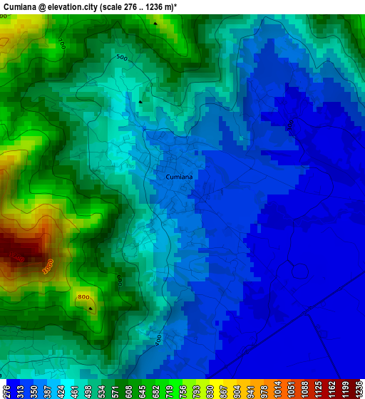
Below is the Elevation map of Cumiana, which displays elevation range with different colors. Scale of the first map is from 276 to 1236 m (906 to 4055 ft) with average elevation of 469.7 meters (=1541 ft) [note 1]
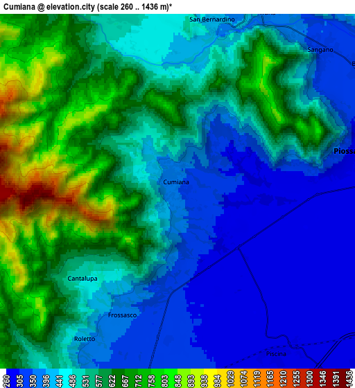
These maps also provides idea of topography and contour of this city, they are displayed at different zoom levels. More info about maps, scale and edge coordinates you can find below images.
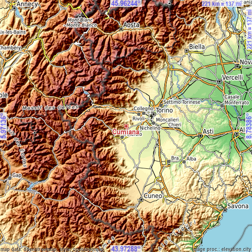
| \ | Map #1 | Map #2 | Topo.Map |
| Scale [m] | 276..1236 m | 260..1436 m | × |
| Scale [ft] | 906..4055 ft | 853..4711 ft | × |
| Average | 469.7 m = 1541 ft | 515.5 m = 1691 ft | × |
| Width | 6.91 km = 4.3 mi | 13.83 km = 8.6 mi | 221.2 km = 137.4 mi |
| Height | 6.91 km = 4.3 mi | 13.83 km = 8.6 mi | 221.2 km = 137.4 mi |
| ↑Max Latitude | 45.007368° | 45.03843° | 45.96244° |
| Latitude at center | 44.97629° | 44.97629° | 44.97629° |
| ↓Min Latitude | 44.945195° | 44.914083° | 43.97288° |
| ← Min Longitude | 7.333665° | 7.289719° | 5.97136° |
| Longitude center | 7.37761° | 7.37761° | 7.37761° |
| →Max Longitude | 7.421555° | 7.465501° | 8.78386° |
Nearby cities:
Cities around Cumiana sort by population:
• Piossasco elevation 310 m
6.6 km,  78°
78°
• Giaveno 538 m
7.9 km,  342°
342°
• Bruino 306 m
9 km,  61°
61°
• Sangano 340 m
7.9 km,  46°
46°
• Piscina 286 m
7.4 km,  149°
149°
• Frossasco 321 m
6.1 km,  184°
184°
• Cantalupa 498 m
5 km,  227°
227°
• Trana 375 m
7.7 km,  26°
26°
• Reano 453 m
9.3 km, 25°
• Riva 325 m
9.3 km, 177°
• San Pietro Val Lemina 460 m
9.4 km,  214°
214°
• Roletto 401 m
6.8 km, 211°
Multilingual:
 En español:
Cumiana elevación 351 m.
 En France:
Cumiana élévation 351 m.


Sources and notes:
- [note 1] Map square and city borders are not equal. Map elevation data is calculated only from area inside that square.
- [src 1] Elevation data from geonames database provided with same terms of usage.
- [src 2] The elevation map of Cumiana is generated using elevation data from NASA's 3 arcsec (90m) resolution SRTM data.
- [src 3] Base (background) map © OpenStreetMap contributors tiles are generated by Geofabrik and OpenTopoMap.
Copyright & License:
This Cumiana Elevation Map is licensed under CC BY-SA. You may reuse any part from this page, if you give a proper credit by linking to this URL:
 More info on terms of use page.