Roletto elevation
Roletto (Piedmont, Torino), Italy elevation is 401 meters and Roletto elevation in feet is 1316 ft above sea level [src 1]. Roletto is a seat of a third-order administrative division (feature code) with elevation that is 79 meters (259 ft) bigger than average city elevation in Italy.
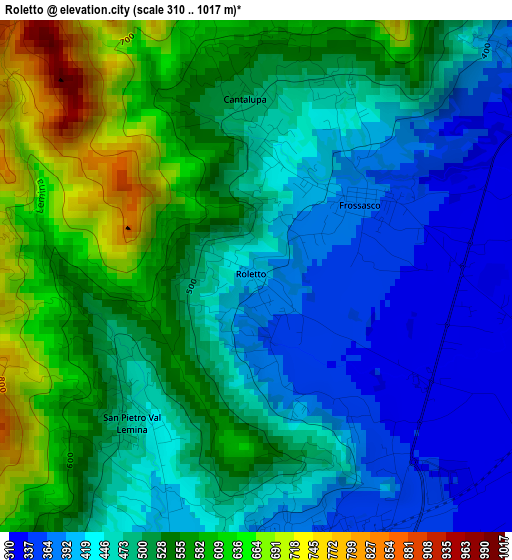
Below is the Elevation map of Roletto, which displays elevation range with different colors. Scale of the first map is from 310 to 1017 m (1017 to 3337 ft) with average elevation of 498.3 meters (=1635 ft) [note 1]
These maps also provides idea of topography and contour of this city, they are displayed at different zoom levels. More info about maps, scale and edge coordinates you can find below images.
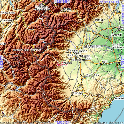
| \ | Map #1 | Topo.Map |
| Scale [m] | 310..1017 m | × |
| Scale [ft] | 1017..3337 ft | × |
| Average | 498.3 m = 1635 ft | × |
| Width | 6.92 km = 4.3 mi | 221.4 km = 137.6 mi |
| Height | 6.92 km = 4.3 mi | 221.4 km = 137.6 mi |
| ↑Max Latitude | 44.955547° | 45.91149° |
| Latitude at center | 44.92444° | 44.92444° |
| ↓Min Latitude | 44.893317° | 43.92013° |
| ← Min Longitude | 7.288375° | 5.92607° |
| Longitude center | 7.33232° | 7.33232° |
| →Max Longitude | 7.376265° | 8.73857° |
Nearby cities:
Cities around Roletto sort by population:
• Pinerolo elevation 379 m
4.3 km,  181°
181°
• Cumiana 351 m
6.8 km,  31°
31°
• Villar Perosa 502 m
6.7 km,  264°
264°
• Piscina 286 m
7.3 km,  94°
94°
• Frossasco 321 m
3.1 km,  95°
95°
• Cantalupa 498 m
2.4 km,  356°
356°
• Riva 325 m
5.3 km,  132°
132°
• San Germano Chisone 532 m
7.9 km,  251°
251°
• San Secondo di Pinerolo 420 m
7 km,  202°
202°
• Prarostino 747 m
8.2 km,  218°
218°
• San Pietro Val Lemina 460 m
2.6 km, 220°
• Porte 445 m
6.4 km,  229°
229°
Multilingual:
 En español:
Roletto elevación 401 m.
 En France:
Roletto élévation 401 m.


Sources and notes:
- [note 1] Map square and city borders are not equal. Map elevation data is calculated only from area inside that square.
- [src 1] Elevation data from geonames database provided with same terms of usage.
- [src 2] The elevation map of Roletto is generated using elevation data from NASA's 3 arcsec (90m) resolution SRTM data.
- [src 3] Base (background) map © OpenStreetMap contributors tiles are generated by Geofabrik and OpenTopoMap.
Copyright & License:
This Roletto Elevation Map is licensed under CC BY-SA. You may reuse any part from this page, if you give a proper credit by linking to this URL:
 More info on terms of use page.