Porte elevation
Porte (Piedmont, Torino), Italy elevation is 445 meters and Porte elevation in feet is 1460 ft above sea level [src 1]. Porte is a seat of a third-order administrative division (feature code) with elevation that is 123 meters (404 ft) bigger than average city elevation in Italy.
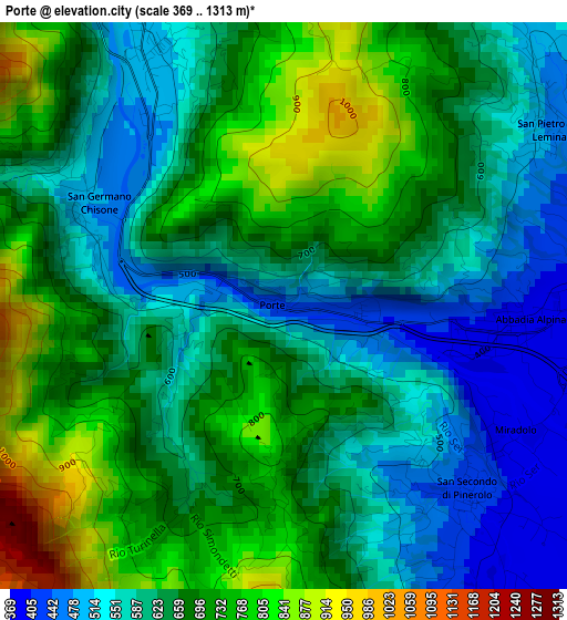
Below is the Elevation map of Porte, which displays elevation range with different colors. Scale of the first map is from 369 to 1313 m (1211 to 4308 ft) with average elevation of 649.1 meters (=2130 ft) [note 1]
These maps also provides idea of topography and contour of this city, they are displayed at different zoom levels. More info about maps, scale and edge coordinates you can find below images.
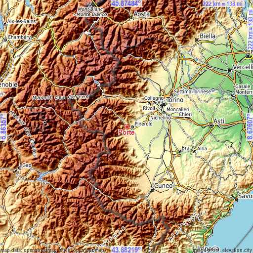
| \ | Map #1 | Topo.Map |
| Scale [m] | 369..1313 m | × |
| Scale [ft] | 1211..4308 ft | × |
| Average | 649.1 m = 2130 ft | × |
| Width | 6.92 km = 4.3 mi | 221.6 km = 137.7 mi |
| Height | 6.92 km = 4.3 mi | 221.6 km = 137.7 mi |
| ↑Max Latitude | 44.918267° | 45.87484° |
| Latitude at center | 44.88714° | 44.88714° |
| ↓Min Latitude | 44.855996° | 43.88219° |
| ← Min Longitude | 7.225875° | 5.86357° |
| Longitude center | 7.26982° | 7.26982° |
| →Max Longitude | 7.313765° | 8.67607° |
Nearby cities:
Cities around Porte sort by population:
• Pinerolo elevation 379 m
4.9 km,  92°
92°
• Villar Perosa 502 m
3.9 km,  333°
333°
• Bricherasio 389 m
7.6 km,  159°
159°
• Pinasca-Dubbione 549 m
7 km, 332°
• San Germano Chisone 532 m
3.1 km,  302°
302°
• San Secondo di Pinerolo 420 m
3.2 km,  135°
135°
• Prarostino 747 m
2.3 km,  184°
184°
• San Pietro Val Lemina 460 m
3.9 km,  56°
56°
• Roletto 401 m
6.4 km,  49°
49°
• Osasco 346 m
7.1 km,  126°
126°
• Pramollo 1071 m
6.7 km,  290°
290°
• Angrogna 758 m
6 km,  216°
216°
Multilingual:
 En español:
Porte elevación 445 m.
 En France:
Porte élévation 445 m.


Sources and notes:
- [note 1] Map square and city borders are not equal. Map elevation data is calculated only from area inside that square.
- [src 1] Elevation data from geonames database provided with same terms of usage.
- [src 2] The elevation map of Porte is generated using elevation data from NASA's 3 arcsec (90m) resolution SRTM data.
- [src 3] Base (background) map © OpenStreetMap contributors tiles are generated by Geofabrik and OpenTopoMap.
Copyright & License:
This Porte Elevation Map is licensed under CC BY-SA. You may reuse any part from this page, if you give a proper credit by linking to this URL:
 More info on terms of use page.