Angrogna elevation
Angrogna (Piedmont, Torino), Italy elevation is 758 meters and Angrogna elevation in feet is 2487 ft above sea level [src 1]. Angrogna is a seat of a third-order administrative division (feature code) with elevation that is 436 meters (1430 ft) bigger than average city elevation in Italy.
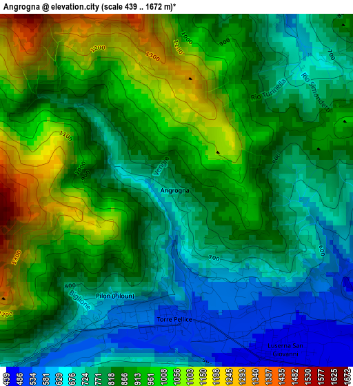
Below is the Elevation map of Angrogna, which displays elevation range with different colors. Scale of the first map is from 439 to 1672 m (1440 to 5486 ft) with average elevation of 854.6 meters (=2804 ft) [note 1]
These maps also provides idea of topography and contour of this city, they are displayed at different zoom levels. More info about maps, scale and edge coordinates you can find below images.
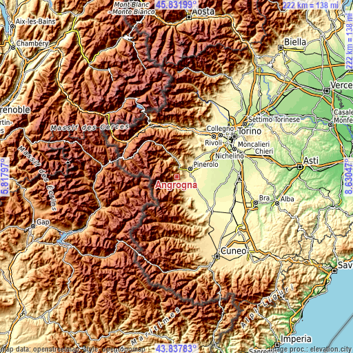
| \ | Map #1 | Topo.Map |
| Scale [m] | 439..1672 m | × |
| Scale [ft] | 1440..5486 ft | × |
| Average | 854.6 m = 2804 ft | × |
| Width | 6.93 km = 4.3 mi | 221.7 km = 137.8 mi |
| Height | 6.93 km = 4.3 mi | 221.7 km = 137.8 mi |
| ↑Max Latitude | 44.87469° | 45.83199° |
| Latitude at center | 44.84354° | 44.84354° |
| ↓Min Latitude | 44.812373° | 43.83783° |
| ← Min Longitude | 7.180275° | 5.81797° |
| Longitude center | 7.22422° | 7.22422° |
| →Max Longitude | 7.268165° | 8.63047° |
Nearby cities:
Cities around Angrogna sort by population:
• Airali elevation 472 m
3.7 km,  144°
144°
• Torre Pellice 539 m
2.6 km,  193°
193°
• Bricherasio 389 m
6.6 km,  109°
109°
• Bibiana 415 m
7.1 km,  134°
134°
• San Germano Chisone 532 m
6.6 km,  8°
8°
• San Secondo di Pinerolo 420 m
6.4 km,  66°
66°
• Prarostino 747 m
4.3 km,  53°
53°
• Luserna 499 m
4.4 km,  157°
157°
• Villar Pellice 676 m
6.4 km,  232°
232°
• Porte 445 m
6 km,  36°
36°
• Lusernetta 502 m
4.8 km, 158°
• Rorà 954 m
6.1 km,  199°
199°
Multilingual:
 En español:
Angrogna elevación 758 m.
 En France:
Angrogna élévation 758 m.
 Auf Deutsch:
Angrogna höhe über dem Meeresspiegel ist 758 m.

Sources and notes:
- [note 1] Map square and city borders are not equal. Map elevation data is calculated only from area inside that square.
- [src 1] Elevation data from geonames database provided with same terms of usage.
- [src 2] The elevation map of Angrogna is generated using elevation data from NASA's 3 arcsec (90m) resolution SRTM data.
- [src 3] Base (background) map © OpenStreetMap contributors tiles are generated by Geofabrik and OpenTopoMap.
Copyright & License:
This Angrogna Elevation Map is licensed under CC BY-SA. You may reuse any part from this page, if you give a proper credit by linking to this URL:
 More info on terms of use page.