Airasca elevation
Airasca (Piedmont, Torino), Italy elevation is 260 meters and Airasca elevation in feet is 853 ft above sea level [src 1]. Airasca is a seat of a third-order administrative division (feature code) with elevation that is 62 meters (203 ft) smaller than average city elevation in Italy.
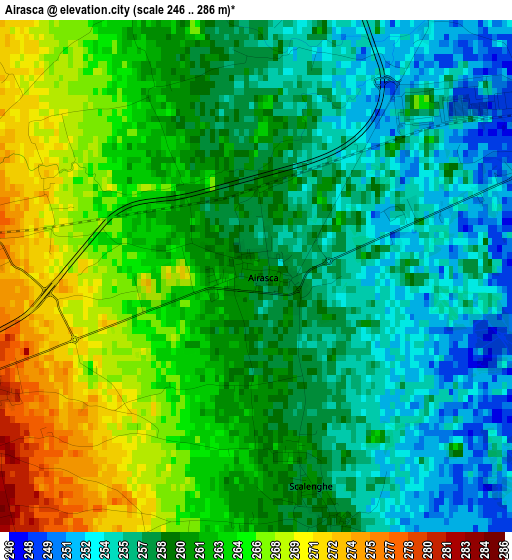
Below is the Elevation map of Airasca, which displays elevation range with different colors. Scale of the first map is from 246 to 286 m (807 to 938 ft) with average elevation of 260.5 meters (=855 ft) [note 1]
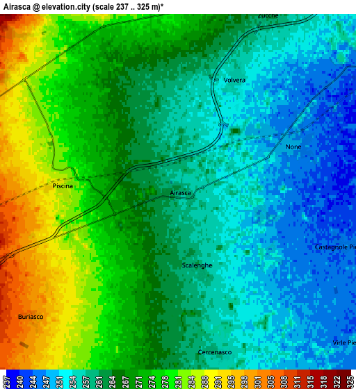
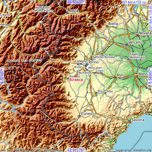
These maps also provides idea of topography and contour of this city, they are displayed at different zoom levels. More info about maps, scale and edge coordinates you can find below images.
| \ | Map #1 | Map #2 | Topo.Map |
| Scale [m] | 246..286 m | 237..325 m | × |
| Scale [ft] | 807..938 ft | 778..1066 ft | × |
| Average | 260.5 m = 855 ft | 265.4 m = 871 ft | × |
| Width | 6.92 km = 4.3 mi | 13.84 km = 8.6 mi | 221.4 km = 137.6 mi |
| Height | 6.92 km = 4.3 mi | 13.84 km = 8.6 mi | 221.4 km = 137.6 mi |
| ↑Max Latitude | 44.9483° | 44.979394° | 45.90437° |
| Latitude at center | 44.91719° | 44.91719° | 44.91719° |
| ↓Min Latitude | 44.886063° | 44.854918° | 43.91276° |
| ← Min Longitude | 7.439275° | 7.395329° | 6.07697° |
| Longitude center | 7.48322° | 7.48322° | 7.48322° |
| →Max Longitude | 7.527165° | 7.571111° | 8.88947° |
Nearby cities:
Cities around Airasca sort by population:
• Piossasco elevation 310 m
8.1 km,  346°
346°
• None 248 m
5 km,  64°
64°
• Volvera 255 m
4.7 km,  27°
27°
• Vigone 259 m
8.4 km,  172°
172°
• Piscina 286 m
4.6 km,  272°
272°
• Gerbole-Zucche 270 m
8.1 km,  18°
18°
• Frossasco 321 m
8.8 km, 273°
• Castagnole Piemonte 246 m
6.9 km,  107°
107°
• Cercenasco 259 m
6.2 km, 169°
• Scalenghe 260 m
3.2 km,  164°
164°
• Riva 325 m
8.4 km,  251°
251°
• Buriasco 300 m
7.5 km,  228°
228°
Multilingual:
 En español:
Airasca elevación 260 m.
 En France:
Airasca élévation 260 m.


Sources and notes:
- [note 1] Map square and city borders are not equal. Map elevation data is calculated only from area inside that square.
- [src 1] Elevation data from geonames database provided with same terms of usage.
- [src 2] The elevation map of Airasca is generated using elevation data from NASA's 3 arcsec (90m) resolution SRTM data.
- [src 3] Base (background) map © OpenStreetMap contributors tiles are generated by Geofabrik and OpenTopoMap.
Copyright & License:
This Airasca Elevation Map is licensed under CC BY-SA. You may reuse any part from this page, if you give a proper credit by linking to this URL:
 More info on terms of use page.