Albareto elevation
Albareto (Emilia-Romagna, Provincia di Parma), Italy elevation is 525 meters and Albareto elevation in feet is 1722 ft above sea level [src 1]. Albareto is a seat of a third-order administrative division (feature code) with elevation that is 203 meters (666 ft) bigger than average city elevation in Italy.
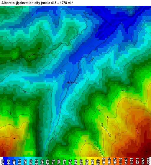
Below is the Elevation map of Albareto, which displays elevation range with different colors. Scale of the first map is from 413 to 1278 m (1355 to 4193 ft) with average elevation of 682.6 meters (=2240 ft) [note 1]
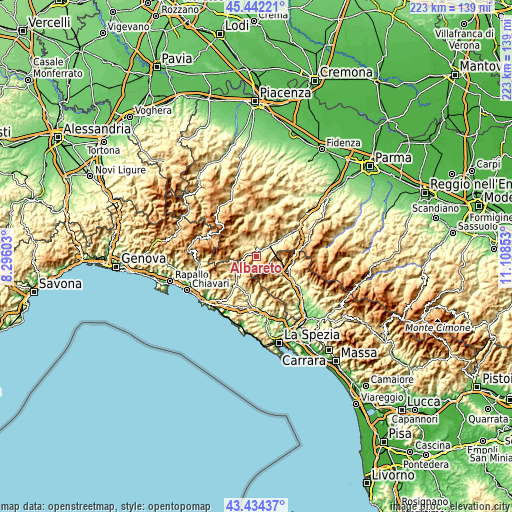
These maps also provides idea of topography and contour of this city, they are displayed at different zoom levels. More info about maps, scale and edge coordinates you can find below images.
| \ | Map #1 | Topo.Map |
| Scale [m] | 413..1278 m | × |
| Scale [ft] | 1355..4193 ft | × |
| Average | 682.6 m = 2240 ft | × |
| Width | 6.98 km = 4.3 mi | 223.3 km = 138.8 mi |
| Height | 6.98 km = 4.3 mi | 223.2 km = 138.7 mi |
| ↑Max Latitude | 44.478284° | 45.44221° |
| Latitude at center | 44.44692° | 44.44692° |
| ↓Min Latitude | 44.415539° | 43.43437° |
| ← Min Longitude | 9.658335° | 8.29603° |
| Longitude center | 9.70228° | 9.70228° |
| →Max Longitude | 9.746225° | 11.10853° |
Nearby cities:
Cities around Albareto sort by population:
• Borgo Val di Taro elevation 410 m
7.1 km,  48°
48°
• Pontremoli 245 m
16.1 km,  119°
119°
• Bedonia 533 m
8.3 km,  319°
319°
• Zeri 748 m
11.4 km,  154°
154°
• Bardi 610 m
20.6 km,  5°
5°
• Sesta Godano 252 m
17.2 km,  187°
187°
• Varese Ligure 358 m
11.6 km,  227°
227°
• Pieve di Zignago 621 m
19.1 km,  169°
169°
• Patigno 748 m
11.5 km,  155°
155°
• Tornolo 588 m
7.3 km,  305°
305°
• Compiano 519 m
6.3 km,  329°
329°
• Maissana 556 m
18 km, 227°
Multilingual:
 En español:
Albareto elevación 525 m.
 En France:
Albareto élévation 525 m.
 Auf Deutsch:
Albareto höhe über dem Meeresspiegel ist 525 m.

Sources and notes:
- [note 1] Map square and city borders are not equal. Map elevation data is calculated only from area inside that square.
- [src 1] Elevation data from geonames database provided with same terms of usage.
- [src 2] The elevation map of Albareto is generated using elevation data from NASA's 3 arcsec (90m) resolution SRTM data.
- [src 3] Base (background) map © OpenStreetMap contributors tiles are generated by Geofabrik and OpenTopoMap.
Copyright & License:
This Albareto Elevation Map is licensed under CC BY-SA. You may reuse any part from this page, if you give a proper credit by linking to this URL:
 More info on terms of use page.