Bedonia elevation
Bedonia (Emilia-Romagna, Provincia di Parma), Italy elevation is 533 meters and Bedonia elevation in feet is 1749 ft above sea level [src 1]. Bedonia is a seat of a third-order administrative division (feature code) with elevation that is 211 meters (692 ft) bigger than average city elevation in Italy.
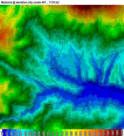
Below is the Elevation map of Bedonia, which displays elevation range with different colors. Scale of the first map is from 447 to 1119 m (1467 to 3671 ft) with average elevation of 643.6 meters (=2112 ft) [note 1]
These maps also provides idea of topography and contour of this city, they are displayed at different zoom levels. More info about maps, scale and edge coordinates you can find below images.
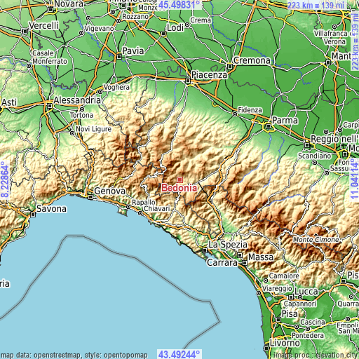
| \ | Map #1 | Topo.Map |
| Scale [m] | 447..1119 m | × |
| Scale [ft] | 1467..3671 ft | × |
| Average | 643.6 m = 2112 ft | × |
| Width | 6.97 km = 4.3 mi | 223 km = 138.6 mi |
| Height | 6.97 km = 4.3 mi | 223 km = 138.6 mi |
| ↑Max Latitude | 44.535333° | 45.49831° |
| Latitude at center | 44.504° | 44.504° |
| ↓Min Latitude | 44.47265° | 43.49244° |
| ← Min Longitude | 9.590945° | 8.22864° |
| Longitude center | 9.63489° | 9.63489° |
| →Max Longitude | 9.678835° | 11.04114° |
Nearby cities:
Cities around Bedonia sort by population:
• Borgo Val di Taro elevation 410 m
10.8 km,  98°
98°
• Zeri 748 m
19.6 km,  148°
148°
• Bardi 610 m
16 km,  27°
27°
• Albareto 525 m
8.3 km,  139°
139°
• Varese Ligure 358 m
14.5 km,  193°
193°
• Santo Stefano d'Aveto 1034 m
15.2 km,  288°
288°
• Ferriere 647 m
19 km,  324°
324°
• Patigno 748 m
19.6 km, 148°
• Tornolo 588 m
2.2 km,  195°
195°
• Compiano 519 m
2.3 km,  112°
112°
• Rezzoaglio 721 m
19.7 km,  277°
277°
• Maissana 556 m
20.2 km, 202°
Multilingual:
 En español:
Bedonia elevación 533 m.
 En France:
Bedonia élévation 533 m.


Sources and notes:
- [note 1] Map square and city borders are not equal. Map elevation data is calculated only from area inside that square.
- [src 1] Elevation data from geonames database provided with same terms of usage.
- [src 2] The elevation map of Bedonia is generated using elevation data from NASA's 3 arcsec (90m) resolution SRTM data.
- [src 3] Base (background) map © OpenStreetMap contributors tiles are generated by Geofabrik and OpenTopoMap.
Copyright & License:
This Bedonia Elevation Map is licensed under CC BY-SA. You may reuse any part from this page, if you give a proper credit by linking to this URL:
 More info on terms of use page.