Varese Ligure elevation
Varese Ligure (Liguria, Provincia di La Spezia), Italy elevation is 358 meters and Varese Ligure elevation in feet is 1175 ft above sea level [src 1]. Varese Ligure is a seat of a third-order administrative division (feature code) with elevation that is 36 meters (118 ft) bigger than average city elevation in Italy.
Below is the Elevation map of Varese Ligure, which displays elevation range with different colors. Scale of the first map is from 296 to 1082 m (971 to 3550 ft) with average elevation of 558.9 meters (=1834 ft) [note 1]
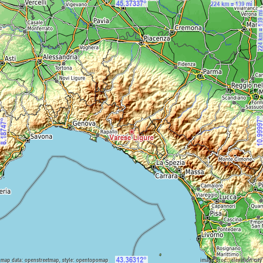
These maps also provides idea of topography and contour of this city, they are displayed at different zoom levels. More info about maps, scale and edge coordinates you can find below images.
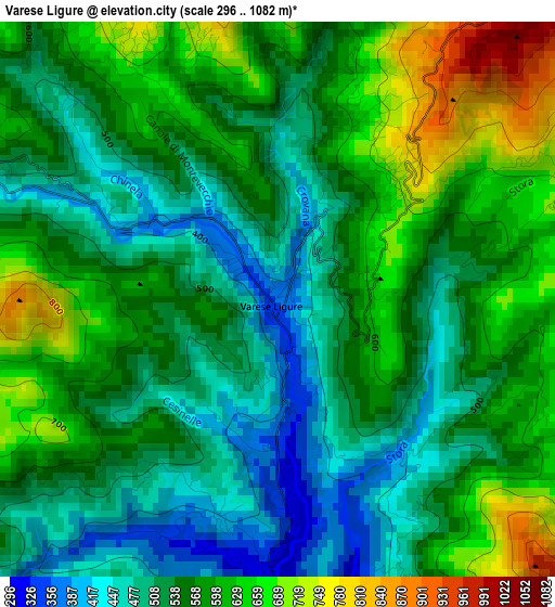
| \ | Map #1 | Topo.Map |
| Scale [m] | 296..1082 m | × |
| Scale [ft] | 971..3550 ft | × |
| Average | 558.9 m = 1834 ft | × |
| Width | 6.98 km = 4.3 mi | 223.5 km = 138.9 mi |
| Height | 6.99 km = 4.3 mi | 223.5 km = 138.9 mi |
| ↑Max Latitude | 44.408272° | 45.37337° |
| Latitude at center | 44.37687° | 44.37687° |
| ↓Min Latitude | 44.345451° | 43.36312° |
| ← Min Longitude | 9.549775° | 8.18747° |
| Longitude center | 9.59372° | 9.59372° |
| →Max Longitude | 9.637665° | 10.99997° |
Nearby cities:
Cities around Varese Ligure sort by population:
• Bedonia elevation 533 m
14.5 km,  13°
13°
• Zeri 748 m
13.7 km,  100°
100°
• Conscenti 57 m
16.2 km,  257°
257°
• Sesta Godano 252 m
11.3 km,  144°
144°
• Carrodano 216 m
15.8 km,  161°
161°
• Albareto 525 m
11.6 km,  47°
47°
• Castiglione 273 m
12.8 km,  208°
208°
• Carro 391 m
11.7 km,  174°
174°
• Patigno 748 m
13.7 km, 101°
• Tornolo 588 m
12.3 km, 12°
• Compiano 519 m
14.3 km,  22°
22°
• Maissana 556 m
6.4 km,  225°
225°
Multilingual:
 En español:
Varese Ligure elevación 358 m.
 En France:
Varese Ligure élévation 358 m.
 Auf Deutsch:
Varese Ligure höhe über dem Meeresspiegel ist 358 m.

Sources and notes:
- [note 1] Map square and city borders are not equal. Map elevation data is calculated only from area inside that square.
- [src 1] Elevation data from geonames database provided with same terms of usage.
- [src 2] The elevation map of Varese Ligure is generated using elevation data from NASA's 3 arcsec (90m) resolution SRTM data.
- [src 3] Base (background) map © OpenStreetMap contributors tiles are generated by Geofabrik and OpenTopoMap.
Copyright & License:
This Varese Ligure Elevation Map is licensed under CC BY-SA. You may reuse any part from this page, if you give a proper credit by linking to this URL:
 More info on terms of use page.