Zeri elevation
Zeri (Tuscany, Provincia di Massa-Carrara), Italy elevation is 748 meters and Zeri elevation in feet is 2454 ft above sea level [src 1]. Zeri is a seat of a third-order administrative division (feature code) with elevation that is 426 meters (1398 ft) bigger than average city elevation in Italy.
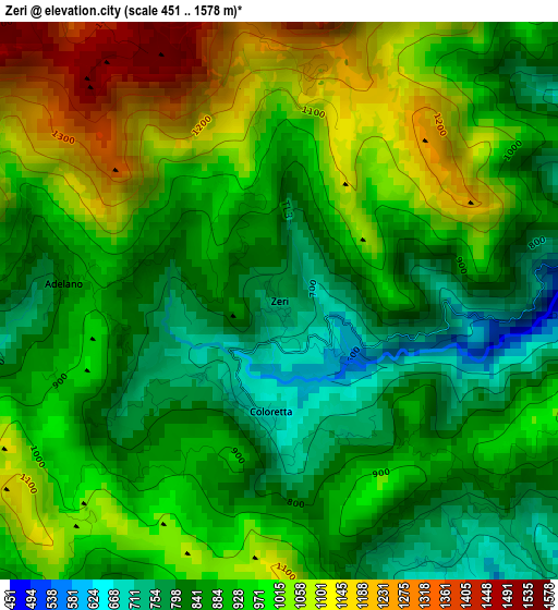
Below is the Elevation map of Zeri, which displays elevation range with different colors. Scale of the first map is from 451 to 1578 m (1480 to 5177 ft) with average elevation of 937.4 meters (=3075 ft) [note 1]
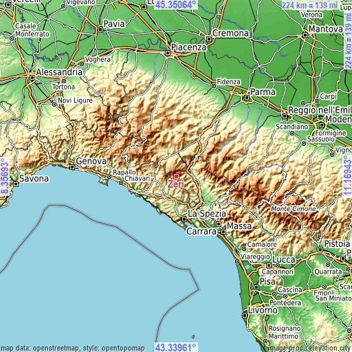
These maps also provides idea of topography and contour of this city, they are displayed at different zoom levels. More info about maps, scale and edge coordinates you can find below images.
| \ | Map #1 | Topo.Map |
| Scale [m] | 451..1578 m | × |
| Scale [ft] | 1480..5177 ft | × |
| Average | 937.4 m = 3075 ft | × |
| Width | 6.99 km = 4.3 mi | 223.6 km = 138.9 mi |
| Height | 6.99 km = 4.3 mi | 223.6 km = 138.9 mi |
| ↑Max Latitude | 44.385164° | 45.35064° |
| Latitude at center | 44.35375° | 44.35375° |
| ↓Min Latitude | 44.322319° | 43.33961° |
| ← Min Longitude | 9.719235° | 8.35693° |
| Longitude center | 9.76318° | 9.76318° |
| →Max Longitude | 9.807125° | 11.16943° |
Nearby cities:
Cities around Zeri sort by population:
• Pontremoli elevation 245 m
9.5 km,  75°
75°
• Brugnato 116 m
13.4 km,  193°
193°
• Filattiera 154 m
13.8 km,  101°
101°
• Sesta Godano 252 m
9.7 km,  226°
226°
• Borghetto di Vara 103 m
14.8 km, 193°
• Albareto 525 m
11.4 km,  334°
334°
• Varese Ligure 358 m
13.7 km,  280°
280°
• Pieve di Zignago 621 m
8.5 km, 189°
• Patigno 748 m
0.1 km, 194°
• Mulazzo 318 m
11 km,  112°
112°
• Rocchetta di Vara 220 m
11.5 km,  182°
182°
• Calice al Cornoviglio 399 m
13.6 km,  154°
154°
Multilingual:
 En español:
Zeri elevación 748 m.
 En France:
Zeri élévation 748 m.


Sources and notes:
- [note 1] Map square and city borders are not equal. Map elevation data is calculated only from area inside that square.
- [src 1] Elevation data from geonames database provided with same terms of usage.
- [src 2] The elevation map of Zeri is generated using elevation data from NASA's 3 arcsec (90m) resolution SRTM data.
- [src 3] Base (background) map © OpenStreetMap contributors tiles are generated by Geofabrik and OpenTopoMap.
Copyright & License:
This Zeri Elevation Map is licensed under CC BY-SA. You may reuse any part from this page, if you give a proper credit by linking to this URL:
 More info on terms of use page.