Carrodano elevation
Carrodano (Liguria, Provincia di La Spezia), Italy elevation is 216 meters and Carrodano elevation in feet is 709 ft above sea level [src 1]. Carrodano is a seat of a third-order administrative division (feature code) with elevation that is 106 meters (348 ft) smaller than average city elevation in Italy.
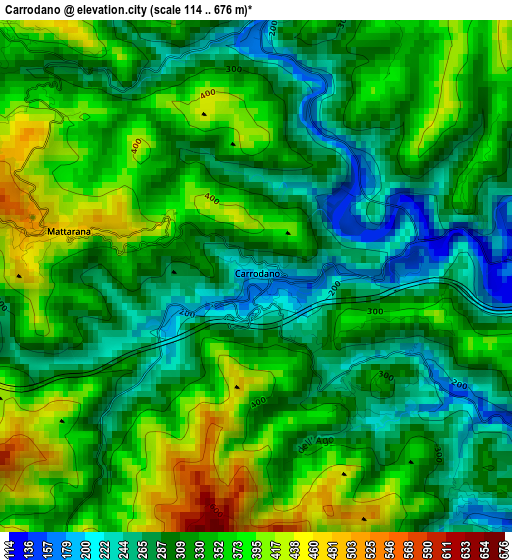
Below is the Elevation map of Carrodano, which displays elevation range with different colors. Scale of the first map is from 114 to 676 m (374 to 2218 ft) with average elevation of 325.8 meters (=1069 ft) [note 1]
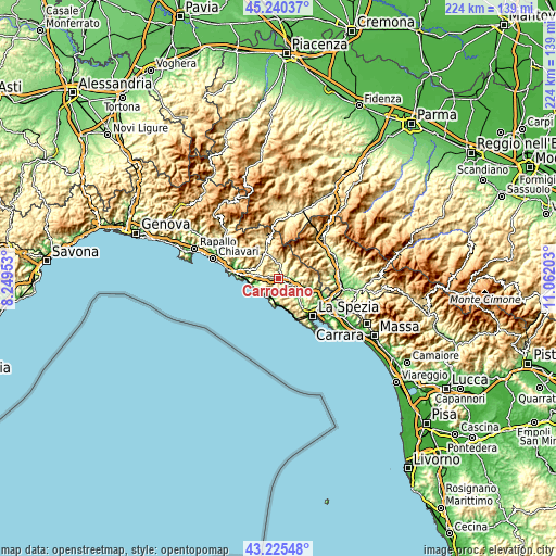
These maps also provides idea of topography and contour of this city, they are displayed at different zoom levels. More info about maps, scale and edge coordinates you can find below images.
| \ | Map #1 | Topo.Map |
| Scale [m] | 114..676 m | × |
| Scale [ft] | 374..2218 ft | × |
| Average | 325.8 m = 1069 ft | × |
| Width | 7 km = 4.3 mi | 224 km = 139.2 mi |
| Height | 7 km = 4.3 mi | 224 km = 139.2 mi |
| ↑Max Latitude | 44.273024° | 45.24037° |
| Latitude at center | 44.24155° | 44.24155° |
| ↓Min Latitude | 44.210059° | 43.22548° |
| ← Min Longitude | 9.611835° | 8.24953° |
| Longitude center | 9.65578° | 9.65578° |
| →Max Longitude | 9.699725° | 11.06203° |
Nearby cities:
Cities around Carrodano sort by population:
• Levanto elevation 13 m
8.1 km,  202°
202°
• Monterosso al Mare 12 m
10.6 km,  180°
180°
• Brugnato 116 m
5.5 km,  95°
95°
• Framura 160 m
8.9 km,  246°
246°
• Sesta Godano 252 m
6 km,  15°
15°
• Borghetto di Vara 103 m
5.6 km,  110°
110°
• Bonassola 12 m
8.6 km,  221°
221°
• Pieve di Zignago 621 m
8.2 km,  60°
60°
• Pignone 180 m
8.9 km,  142°
142°
• Carro 391 m
5.1 km,  312°
312°
• Padivarma 76 m
10.2 km,  119°
119°
• Rocchetta di Vara 220 m
8.2 km,  82°
82°
Multilingual:
 En español:
Carrodano elevación 216 m.
 En France:
Carrodano élévation 216 m.
 Auf Deutsch:
Carrodano höhe über dem Meeresspiegel ist 216 m.

Sources and notes:
- [note 1] Map square and city borders are not equal. Map elevation data is calculated only from area inside that square.
- [src 1] Elevation data from geonames database provided with same terms of usage.
- [src 2] The elevation map of Carrodano is generated using elevation data from NASA's 3 arcsec (90m) resolution SRTM data.
- [src 3] Base (background) map © OpenStreetMap contributors tiles are generated by Geofabrik and OpenTopoMap.
Copyright & License:
This Carrodano Elevation Map is licensed under CC BY-SA. You may reuse any part from this page, if you give a proper credit by linking to this URL:
 More info on terms of use page.