Padivarma elevation
Padivarma (Liguria, Provincia di La Spezia), Italy elevation is 76 meters and Padivarma elevation in feet is 249 ft above sea level [src 1]. Padivarma is a seat of a third-order administrative division (feature code) with elevation that is 246 meters (807 ft) smaller than average city elevation in Italy.
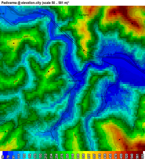
Below is the Elevation map of Padivarma, which displays elevation range with different colors. Scale of the first map is from 50 to 581 m (164 to 1906 ft) with average elevation of 205.9 meters (=676 ft) [note 1]
These maps also provides idea of topography and contour of this city, they are displayed at different zoom levels. More info about maps, scale and edge coordinates you can find below images.
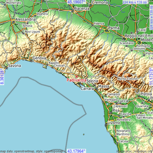
| \ | Map #1 | Topo.Map |
| Scale [m] | 50..581 m | × |
| Scale [ft] | 164..1906 ft | × |
| Average | 205.9 m = 676 ft | × |
| Width | 7.01 km = 4.4 mi | 224.2 km = 139.3 mi |
| Height | 7.01 km = 4.4 mi | 224.2 km = 139.3 mi |
| ↑Max Latitude | 44.227978° | 45.19607° |
| Latitude at center | 44.19648° | 44.19648° |
| ↓Min Latitude | 44.164965° | 43.17964° |
| ← Min Longitude | 9.723585° | 8.36128° |
| Longitude center | 9.76753° | 9.76753° |
| →Max Longitude | 9.811475° | 11.17378° |
Nearby cities:
Cities around Padivarma sort by population:
• Ceparana-Carpena elevation 30 m
9.8 km,  109°
109°
• Piano di Follo 31 m
8.4 km,  115°
115°
• Piana Battolla 43 m
6.9 km,  93°
93°
• Brugnato 116 m
5.6 km,  322°
322°
• Riccò del Golfo 145 m
4.7 km,  183°
183°
• Borghetto di Vara 103 m
4.8 km,  309°
309°
• Pieve di Zignago 621 m
9.2 km,  349°
349°
• Vernazza 21 m
9.6 km,  224°
224°
• Pignone 180 m
4.1 km,  239°
239°
• Rocchetta di Vara 220 m
6.1 km, 352°
• Calice al Cornoviglio 399 m
7.6 km,  46°
46°
• Beverino 221 m
1.4 km,  84°
84°
Multilingual:
 En español:
Padivarma elevación 76 m.
 En France:
Padivarma élévation 76 m.
 Auf Deutsch:
Padivarma höhe über dem Meeresspiegel ist 76 m.

Sources and notes:
- [note 1] Map square and city borders are not equal. Map elevation data is calculated only from area inside that square.
- [src 1] Elevation data from geonames database provided with same terms of usage.
- [src 2] The elevation map of Padivarma is generated using elevation data from NASA's 3 arcsec (90m) resolution SRTM data.
- [src 3] Base (background) map © OpenStreetMap contributors tiles are generated by Geofabrik and OpenTopoMap.
Copyright & License:
This Padivarma Elevation Map is licensed under CC BY-SA. You may reuse any part from this page, if you give a proper credit by linking to this URL:
 More info on terms of use page.