Bardi elevation
Bardi (Emilia-Romagna, Provincia di Parma), Italy elevation is 610 meters and Bardi elevation in feet is 2001 ft above sea level [src 1]. Bardi is a seat of a third-order administrative division (feature code) with elevation that is 288 meters (945 ft) bigger than average city elevation in Italy.
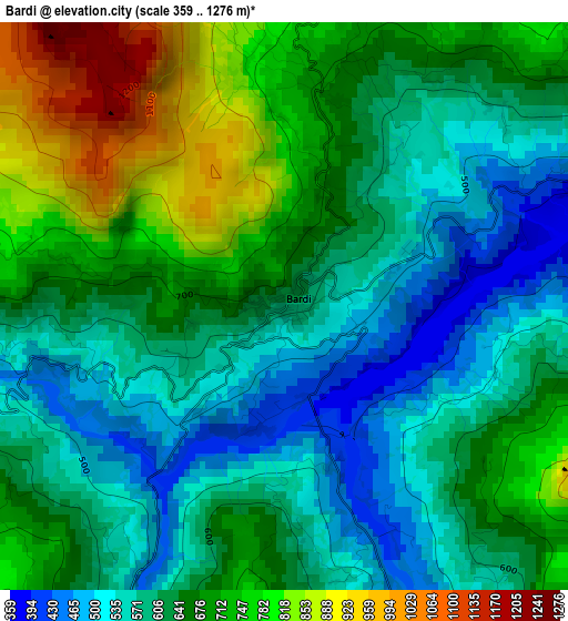
Below is the Elevation map of Bardi, which displays elevation range with different colors. Scale of the first map is from 359 to 1276 m (1178 to 4186 ft) with average elevation of 644.3 meters (=2114 ft) [note 1]
These maps also provides idea of topography and contour of this city, they are displayed at different zoom levels. More info about maps, scale and edge coordinates you can find below images.
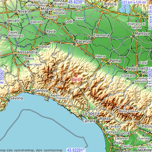
| \ | Map #1 | Topo.Map |
| Scale [m] | 359..1276 m | × |
| Scale [ft] | 1178..4186 ft | × |
| Average | 644.3 m = 2114 ft | × |
| Width | 6.95 km = 4.3 mi | 222.5 km = 138.3 mi |
| Height | 6.95 km = 4.3 mi | 222.5 km = 138.3 mi |
| ↑Max Latitude | 44.662645° | 45.6235° |
| Latitude at center | 44.63138° | 44.63138° |
| ↓Min Latitude | 44.600098° | 43.62201° |
| ← Min Longitude | 9.685125° | 8.32282° |
| Longitude center | 9.72907° | 9.72907° |
| →Max Longitude | 9.773015° | 11.13532° |
Nearby cities:
Cities around Bardi sort by population:
• Borgo Val di Taro elevation 410 m
16.1 km,  168°
168°
• Bettola 328 m
18.9 km,  329°
329°
• Bedonia 533 m
16 km,  207°
207°
• Varsi 449 m
10.1 km,  69°
69°
• Pellegrino Parmense 427 m
19.4 km,  55°
55°
• Bore 849 m
10.9 km,  27°
27°
• Ferriere 647 m
18.4 km,  274°
274°
• Farini 428 m
15.6 km,  305°
305°
• Morfasso 638 m
10.4 km,  348°
348°
• Tornolo 588 m
18.1 km, 206°
• Compiano 519 m
16 km,  199°
199°
• Stazione Valmozzola 273 m
17.9 km,  109°
109°
Multilingual:
 En español:
Bardi elevación 610 m.
 En France:
Bardi élévation 610 m.


Sources and notes:
- [note 1] Map square and city borders are not equal. Map elevation data is calculated only from area inside that square.
- [src 1] Elevation data from geonames database provided with same terms of usage.
- [src 2] The elevation map of Bardi is generated using elevation data from NASA's 3 arcsec (90m) resolution SRTM data.
- [src 3] Base (background) map © OpenStreetMap contributors tiles are generated by Geofabrik and OpenTopoMap.
Copyright & License:
This Bardi Elevation Map is licensed under CC BY-SA. You may reuse any part from this page, if you give a proper credit by linking to this URL:
 More info on terms of use page.