Bettola elevation
Bettola (Emilia-Romagna, Provincia di Piacenza), Italy elevation is 328 meters and Bettola elevation in feet is 1076 ft above sea level [src 1]. Bettola is a seat of a third-order administrative division (feature code) with elevation that is 6 meters (20 ft) bigger than average city elevation in Italy.
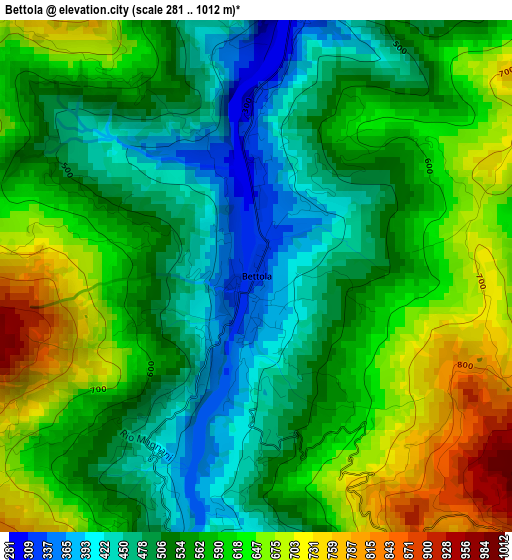
Below is the Elevation map of Bettola, which displays elevation range with different colors. Scale of the first map is from 281 to 1012 m (922 to 3320 ft) with average elevation of 563.4 meters (=1848 ft) [note 1]
These maps also provides idea of topography and contour of this city, they are displayed at different zoom levels. More info about maps, scale and edge coordinates you can find below images.
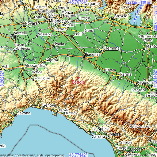
| \ | Map #1 | Topo.Map |
| Scale [m] | 281..1012 m | × |
| Scale [ft] | 922..3320 ft | × |
| Average | 563.4 m = 1848 ft | × |
| Width | 6.94 km = 4.3 mi | 222 km = 137.9 mi |
| Height | 6.94 km = 4.3 mi | 222 km = 137.9 mi |
| ↑Max Latitude | 44.809446° | 45.76784° |
| Latitude at center | 44.77826° | 44.77826° |
| ↓Min Latitude | 44.747058° | 43.77142° |
| ← Min Longitude | 9.564625° | 8.20232° |
| Longitude center | 9.60857° | 9.60857° |
| →Max Longitude | 9.652515° | 11.01482° |
Nearby cities:
Cities around Bettola sort by population:
• Ponte dell'Olio elevation 215 m
10.3 km,  15°
15°
• Rivergaro 144 m
15.2 km,  358°
358°
• Vigolzone 166 m
15.8 km, 17°
• San Giovanni-San Bernardino 327 m
1.6 km,  0°
0°
• Gropparello 396 m
11.3 km,  56°
56°
• Travo 177 m
10.7 km,  331°
331°
• Vernasca 425 m
17.7 km,  82°
82°
• Bore 849 m
15.9 km,  114°
114°
• Ferriere 647 m
17.4 km,  210°
210°
• Farini 428 m
7.9 km,  203°
203°
• Morfasso 638 m
9.6 km,  129°
129°
• Coli 644 m
15.7 km,  256°
256°
Multilingual:
 En español:
Bettola elevación 328 m.
 En France:
Bettola élévation 328 m.


Sources and notes:
- [note 1] Map square and city borders are not equal. Map elevation data is calculated only from area inside that square.
- [src 1] Elevation data from geonames database provided with same terms of usage.
- [src 2] The elevation map of Bettola is generated using elevation data from NASA's 3 arcsec (90m) resolution SRTM data.
- [src 3] Base (background) map © OpenStreetMap contributors tiles are generated by Geofabrik and OpenTopoMap.
Copyright & License:
This Bettola Elevation Map is licensed under CC BY-SA. You may reuse any part from this page, if you give a proper credit by linking to this URL:
 More info on terms of use page.