Rivergaro elevation
Rivergaro (Emilia-Romagna, Provincia di Piacenza), Italy elevation is 144 meters and Rivergaro elevation in feet is 472 ft above sea level [src 1]. Rivergaro is a seat of a third-order administrative division (feature code) with elevation that is 178 meters (584 ft) smaller than average city elevation in Italy.
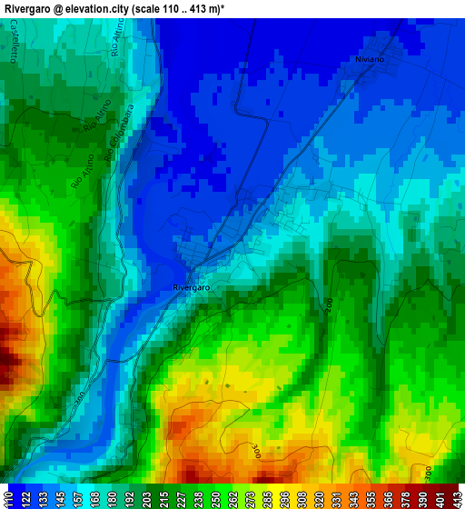
Below is the Elevation map of Rivergaro, which displays elevation range with different colors. Scale of the first map is from 110 to 413 m (361 to 1355 ft) with average elevation of 196.8 meters (=646 ft) [note 1]
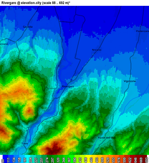
These maps also provides idea of topography and contour of this city, they are displayed at different zoom levels. More info about maps, scale and edge coordinates you can find below images.
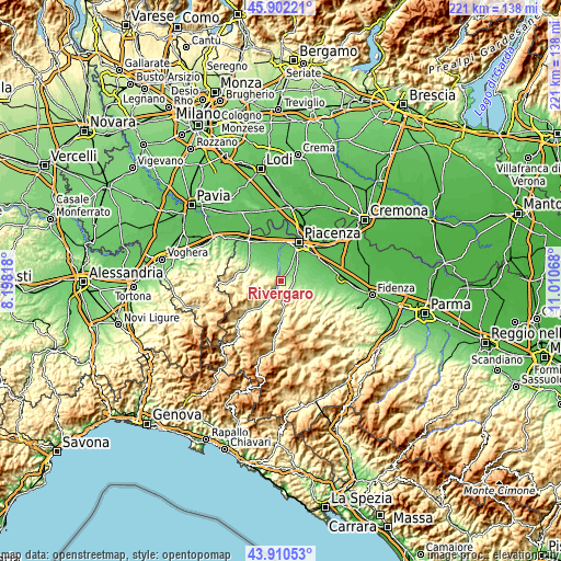
| \ | Map #1 | Map #2 | Topo.Map |
| Scale [m] | 110..413 m | 88..692 m | × |
| Scale [ft] | 361..1355 ft | 289..2270 ft | × |
| Average | 196.8 m = 646 ft | 221.8 m = 728 ft | × |
| Width | 6.92 km = 4.3 mi | 13.84 km = 8.6 mi | 221.5 km = 137.6 mi |
| Height | 6.92 km = 4.3 mi | 13.84 km = 8.6 mi | 221.4 km = 137.6 mi |
| ↑Max Latitude | 44.946112° | 44.977206° | 45.90221° |
| Latitude at center | 44.915° | 44.915° | 44.915° |
| ↓Min Latitude | 44.883871° | 44.852726° | 43.91053° |
| ← Min Longitude | 9.560485° | 9.516539° | 8.19818° |
| Longitude center | 9.60443° | 9.60443° | 9.60443° |
| →Max Longitude | 9.648375° | 9.692321° | 11.01068° |
Nearby cities:
Cities around Rivergaro sort by population:
• Podenzano elevation 120 m
7.6 km,  54°
54°
• San Giorgio Piacentino 104 m
11.3 km,  68°
68°
• Ponte dell'Olio 215 m
6.1 km,  149°
149°
• Gossolengo 87 m
9.8 km,  6°
6°
• Gragnano Trebbiense 79 m
11.1 km,  346°
346°
• Vigolzone 166 m
5 km,  91°
91°
• Niviano 130 m
3.4 km,  34°
34°
• Agazzano 186 m
7.6 km,  298°
298°
• San Polo 87 m
12.9 km,  56°
56°
• Travo 177 m
7.5 km,  219°
219°
• Gazzola 134 m
6.6 km,  318°
318°
• Piozzano 211 m
8.6 km,  277°
277°
Multilingual:
 En español:
Rivergaro elevación 144 m.
 En France:
Rivergaro élévation 144 m.
 Auf Deutsch:
Rivergaro höhe über dem Meeresspiegel ist 144 m.

Sources and notes:
- [note 1] Map square and city borders are not equal. Map elevation data is calculated only from area inside that square.
- [src 1] Elevation data from geonames database provided with same terms of usage.
- [src 2] The elevation map of Rivergaro is generated using elevation data from NASA's 3 arcsec (90m) resolution SRTM data.
- [src 3] Base (background) map © OpenStreetMap contributors tiles are generated by Geofabrik and OpenTopoMap.
Copyright & License:
This Rivergaro Elevation Map is licensed under CC BY-SA. You may reuse any part from this page, if you give a proper credit by linking to this URL:
 More info on terms of use page.