Gragnano Trebbiense elevation
Gragnano Trebbiense (Emilia-Romagna, Provincia di Piacenza), Italy elevation is 79 meters and Gragnano Trebbiense elevation in feet is 259 ft above sea level [src 1]. Gragnano Trebbiense is a seat of a third-order administrative division (feature code) with elevation that is 243 meters (797 ft) smaller than average city elevation in Italy.
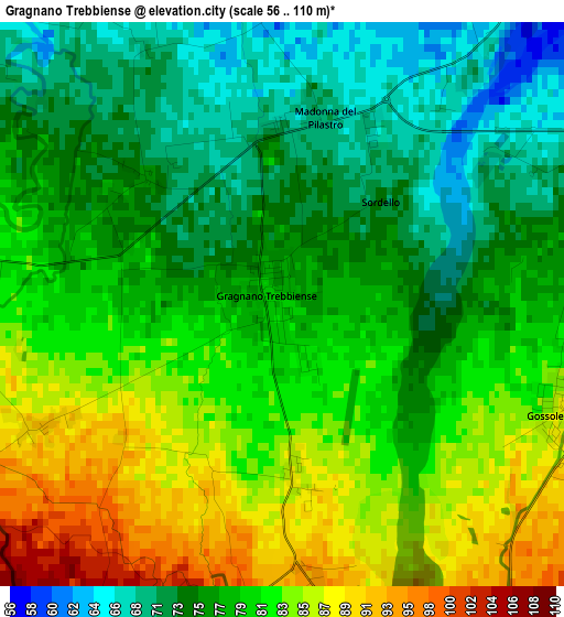
Below is the Elevation map of Gragnano Trebbiense, which displays elevation range with different colors. Scale of the first map is from 56 to 110 m (184 to 361 ft) with average elevation of 79 meters (=259 ft) [note 1]
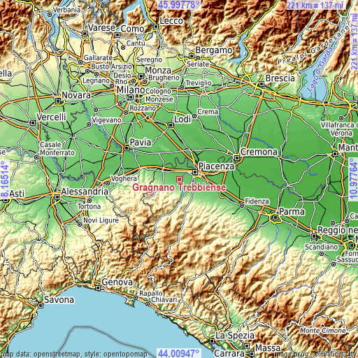
These maps also provides idea of topography and contour of this city, they are displayed at different zoom levels. More info about maps, scale and edge coordinates you can find below images.
| \ | Map #1 | Topo.Map |
| Scale [m] | 56..110 m | × |
| Scale [ft] | 184..361 ft | × |
| Average | 79 m = 259 ft | × |
| Width | 6.91 km = 4.3 mi | 221.1 km = 137.4 mi |
| Height | 6.91 km = 4.3 mi | 221.1 km = 137.4 mi |
| ↑Max Latitude | 45.043309° | 45.99778° |
| Latitude at center | 45.01225° | 45.01225° |
| ↓Min Latitude | 44.981174° | 44.00947° |
| ← Min Longitude | 9.527445° | 8.16514° |
| Longitude center | 9.57139° | 9.57139° |
| →Max Longitude | 9.615335° | 10.97764° |
Nearby cities:
Cities around Gragnano Trebbiense sort by population:
• Piacenza elevation 65 m
10.6 km,  65°
65°
• San Nicolò 61 m
5.6 km,  28°
28°
• Podenzano 120 m
10.9 km,  125°
125°
• Borgonovo Valtidone 110 m
10.1 km,  271°
271°
• Rivergaro 144 m
11.1 km,  166°
166°
• Gossolengo 87 m
3.8 km,  106°
106°
• Sarmato 65 m
7.7 km,  310°
310°
• Rottofreno 63 m
5.1 km,  340°
340°
• Niviano 130 m
9.2 km,  150°
150°
• Agazzano 186 m
8.3 km,  209°
209°
• Calendasco 52 m
8.5 km,  13°
13°
• Gazzola 134 m
6.1 km,  196°
196°
Multilingual:
 En español:
Gragnano Trebbiense elevación 79 m.
 En France:
Gragnano Trebbiense élévation 79 m.
 Auf Deutsch:
Gragnano Trebbiense höhe über dem Meeresspiegel ist 79 m.
 На русском:
Gragnano Trebbiense высота над уровнем моря 79 м
Sources and notes:
- [note 1] Map square and city borders are not equal. Map elevation data is calculated only from area inside that square.
- [src 1] Elevation data from geonames database provided with same terms of usage.
- [src 2] The elevation map of Gragnano Trebbiense is generated using elevation data from NASA's 3 arcsec (90m) resolution SRTM data.
- [src 3] Base (background) map © OpenStreetMap contributors tiles are generated by Geofabrik and OpenTopoMap.
Copyright & License:
This Gragnano Trebbiense Elevation Map is licensed under CC BY-SA. You may reuse any part from this page, if you give a proper credit by linking to this URL:
 More info on terms of use page.