Piacenza elevation
Piacenza (Emilia-Romagna, Provincia di Piacenza), Italy elevation is 65 meters and Piacenza elevation in feet is 213 ft above sea level [src 1]. Piacenza is a seat of a second-order administrative division (feature code) with elevation that is 257 meters (843 ft) smaller than average city elevation in Italy.
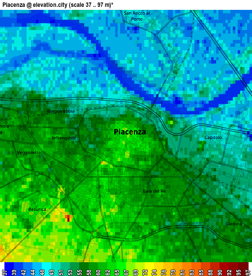
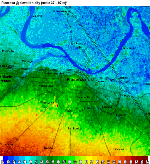
Below is the Elevation map of Piacenza, which displays elevation range with different colors. Scale of the first map is from 37 to 97 m (121 to 318 ft) with average elevation of 54 meters (=177 ft) [note 1]
These maps also provides idea of topography and contour of this city, they are displayed at different zoom levels. More info about maps, scale and edge coordinates you can find below images.
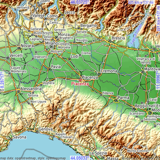
| \ | Map #1 | Map #2 | Topo.Map |
| Scale [m] | 37..97 m | 37..97 m | × |
| Scale [ft] | 121..318 ft | 121..318 ft | × |
| Average | 54 m = 177 ft | 56.3 m = 185 ft | × |
| Width | 6.9 km = 4.3 mi | 13.81 km = 8.6 mi | 220.9 km = 137.3 mi |
| Height | 6.9 km = 4.3 mi | 13.81 km = 8.6 mi | 220.9 km = 137.3 mi |
| ↑Max Latitude | 45.083457° | 45.114477° | 46.03725° |
| Latitude at center | 45.05242° | 45.05242° | 45.05242° |
| ↓Min Latitude | 45.021366° | 44.990295° | 44.05033° |
| ← Min Longitude | 9.649475° | 9.605529° | 8.28717° |
| Longitude center | 9.69342° | 9.69342° | 9.69342° |
| →Max Longitude | 9.737365° | 9.781311° | 11.09967° |
Nearby cities:
Cities around Piacenza sort by population:
• San Nicolò elevation 61 m
6.9 km,  274°
274°
• Pontenure 63 m
9.8 km,  128°
128°
• Gossolengo 87 m
8.1 km,  226°
226°
• San Rocco al Porto 47 m
3.3 km,  5°
5°
• Guardamiglio 46 m
6.2 km,  353°
353°
• San Fiorano 53 m
9.8 km, 12°
• Santo Stefano Lodigiano 46 m
8.1 km,  24°
24°
• Fombio 55 m
9.9 km, 354°
• San Polo 87 m
9 km,  155°
155°
• Corno Giovine 52 m
10.4 km,  29°
29°
• Caselle Landi 45 m
9.8 km,  55°
55°
• Calendasco 52 m
8.5 km,  296°
296°
Multilingual:
 En español:
Plasencia elevación 65 m.
 En France:
Plaisance élévation 65 m.


Sources and notes:
- [note 1] Map square and city borders are not equal. Map elevation data is calculated only from area inside that square.
- [src 1] Elevation data from geonames database provided with same terms of usage.
- [src 2] The elevation map of Piacenza is generated using elevation data from NASA's 3 arcsec (90m) resolution SRTM data.
- [src 3] Base (background) map © OpenStreetMap contributors tiles are generated by Geofabrik and OpenTopoMap.
Copyright & License:
This Piacenza Elevation Map is licensed under CC BY-SA. You may reuse any part from this page, if you give a proper credit by linking to this URL:
 More info on terms of use page.