Calendasco elevation
Calendasco (Emilia-Romagna, Provincia di Piacenza), Italy elevation is 52 meters and Calendasco elevation in feet is 171 ft above sea level [src 1]. Calendasco is a seat of a third-order administrative division (feature code) with elevation that is 270 meters (886 ft) smaller than average city elevation in Italy.
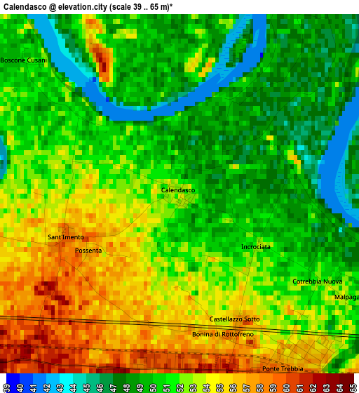
Below is the Elevation map of Calendasco, which displays elevation range with different colors. Scale of the first map is from 39 to 65 m (128 to 213 ft) with average elevation of 51.3 meters (=168 ft) [note 1]
These maps also provides idea of topography and contour of this city, they are displayed at different zoom levels. More info about maps, scale and edge coordinates you can find below images.
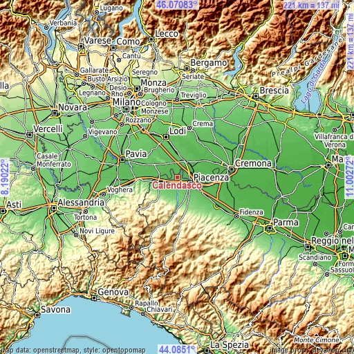
| \ | Map #1 | Topo.Map |
| Scale [m] | 39..65 m | × |
| Scale [ft] | 128..213 ft | × |
| Average | 51.3 m = 168 ft | × |
| Width | 6.9 km = 4.3 mi | 220.8 km = 137.2 mi |
| Height | 6.9 km = 4.3 mi | 220.8 km = 137.2 mi |
| ↑Max Latitude | 45.117609° | 46.07083° |
| Latitude at center | 45.08659° | 45.08659° |
| ↓Min Latitude | 45.055555° | 44.0851° |
| ← Min Longitude | 9.552525° | 8.19022° |
| Longitude center | 9.59647° | 9.59647° |
| →Max Longitude | 9.640415° | 11.00272° |
Nearby cities:
Cities around Calendasco sort by population:
• Piacenza elevation 65 m
8.5 km,  116°
116°
• San Nicolò 61 m
3.4 km,  168°
168°
• San Rocco al Porto 47 m
7.9 km,  93°
93°
• Somaglia 60 m
7.6 km,  22°
22°
• Sarmato 65 m
8.5 km,  247°
247°
• Guardamiglio 46 m
7.3 km,  71°
71°
• Gragnano Trebbiense 79 m
8.5 km,  193°
193°
• Orio Litta 64 m
9.1 km,  338°
338°
• Rottofreno 63 m
5 km,  226°
226°
• Senna Lodigiana 62 m
7.1 km,  358°
358°
• Fombio 55 m
9 km,  47°
47°
• Monticelli Pavese 52 m
7.1 km,  292°
292°
Multilingual:
 En español:
Calendasco elevación 52 m.
 En France:
Calendasco élévation 52 m.
 Auf Deutsch:
Calendasco höhe über dem Meeresspiegel ist 52 m.

Sources and notes:
- [note 1] Map square and city borders are not equal. Map elevation data is calculated only from area inside that square.
- [src 1] Elevation data from geonames database provided with same terms of usage.
- [src 2] The elevation map of Calendasco is generated using elevation data from NASA's 3 arcsec (90m) resolution SRTM data.
- [src 3] Base (background) map © OpenStreetMap contributors tiles are generated by Geofabrik and OpenTopoMap.
Copyright & License:
This Calendasco Elevation Map is licensed under CC BY-SA. You may reuse any part from this page, if you give a proper credit by linking to this URL:
 More info on terms of use page.