Senna Lodigiana elevation
Senna Lodigiana (Lombardy, Provincia di Lodi), Italy elevation is 62 meters and Senna Lodigiana elevation in feet is 203 ft above sea level [src 1]. Senna Lodigiana is a seat of a third-order administrative division (feature code) with elevation that is 260 meters (853 ft) smaller than average city elevation in Italy.
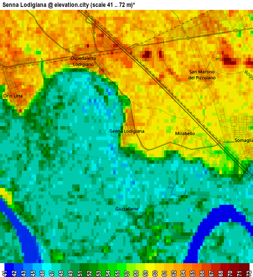
Below is the Elevation map of Senna Lodigiana, which displays elevation range with different colors. Scale of the first map is from 41 to 72 m (135 to 236 ft) with average elevation of 54 meters (=177 ft) [note 1]
These maps also provides idea of topography and contour of this city, they are displayed at different zoom levels. More info about maps, scale and edge coordinates you can find below images.
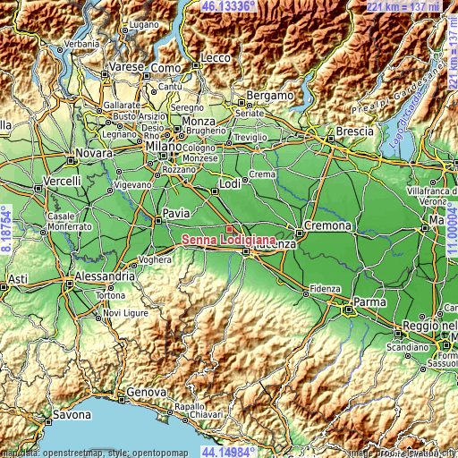
| \ | Map #1 | Topo.Map |
| Scale [m] | 41..72 m | × |
| Scale [ft] | 135..236 ft | × |
| Average | 54 m = 177 ft | × |
| Width | 6.89 km = 4.3 mi | 220.5 km = 137 mi |
| Height | 6.89 km = 4.3 mi | 220.5 km = 137 mi |
| ↑Max Latitude | 45.181214° | 46.13336° |
| Latitude at center | 45.15023° | 45.15023° |
| ↓Min Latitude | 45.119229° | 44.14984° |
| ← Min Longitude | 9.549845° | 8.18754° |
| Longitude center | 9.59379° | 9.59379° |
| →Max Longitude | 9.637735° | 11.00004° |
Nearby cities:
Cities around Senna Lodigiana sort by population:
• Casalpusterlengo elevation 64 m
5.4 km,  53°
53°
• Somaglia 60 m
3.1 km,  91°
91°
• Brembio 64 m
7.1 km,  346°
346°
• Livraga 61 m
6 km,  321°
321°
• Orio Litta 64 m
3.4 km,  293°
293°
• Ospedaletto Lodigiano 63 m
2.4 km,  330°
330°
• Zorlesco 61 m
5.8 km,  17°
17°
• Fombio 55 m
6.9 km,  98°
98°
• Lambrinia 63 m
5.3 km,  279°
279°
• Calendasco 52 m
7.1 km,  178°
178°
• Fornaci 64 m
8.5 km, 50°
• Monticelli Pavese 52 m
7.7 km,  235°
235°
Multilingual:
 En español:
Senna Lodigiana elevación 62 m.
 En France:
Senna Lodigiana élévation 62 m.
 Auf Deutsch:
Senna Lodigiana höhe über dem Meeresspiegel ist 62 m.

Sources and notes:
- [note 1] Map square and city borders are not equal. Map elevation data is calculated only from area inside that square.
- [src 1] Elevation data from geonames database provided with same terms of usage.
- [src 2] The elevation map of Senna Lodigiana is generated using elevation data from NASA's 3 arcsec (90m) resolution SRTM data.
- [src 3] Base (background) map © OpenStreetMap contributors tiles are generated by Geofabrik and OpenTopoMap.
Copyright & License:
This Senna Lodigiana Elevation Map is licensed under CC BY-SA. You may reuse any part from this page, if you give a proper credit by linking to this URL:
 More info on terms of use page.