Alife elevation
Alife (Campania, Provincia di Caserta), Italy elevation is 105 meters and Alife elevation in feet is 344 ft above sea level [src 1]. Alife is a seat of a third-order administrative division (feature code) with elevation that is 217 meters (712 ft) smaller than average city elevation in Italy.
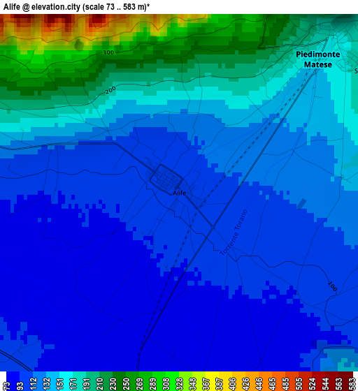
Below is the Elevation map of Alife, which displays elevation range with different colors. Scale of the first map is from 73 to 583 m (240 to 1913 ft) with average elevation of 139.6 meters (=458 ft) [note 1]
These maps also provides idea of topography and contour of this city, they are displayed at different zoom levels. More info about maps, scale and edge coordinates you can find below images.
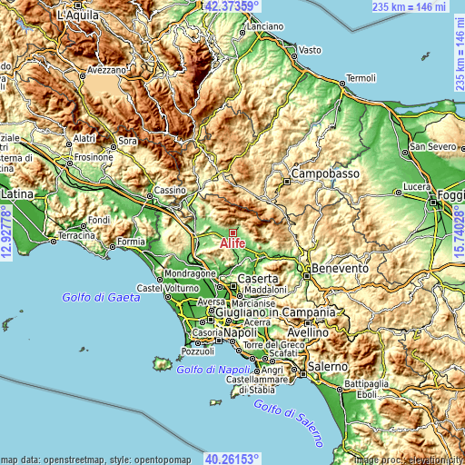
| \ | Map #1 | Topo.Map |
| Scale [m] | 73..583 m | × |
| Scale [ft] | 240..1913 ft | × |
| Average | 139.6 m = 458 ft | × |
| Width | 7.34 km = 4.6 mi | 234.8 km = 145.9 mi |
| Height | 7.34 km = 4.6 mi | 234.8 km = 145.9 mi |
| ↑Max Latitude | 41.359113° | 42.37359° |
| Latitude at center | 41.32612° | 41.32612° |
| ↓Min Latitude | 41.29311° | 40.26153° |
| ← Min Longitude | 14.290085° | 12.92778° |
| Longitude center | 14.33403° | 14.33403° |
| →Max Longitude | 14.377975° | 15.74028° |
Nearby cities:
Cities around Alife sort by population:
• Piedimonte Matese elevation 158 m
3.9 km,  45°
45°
• Alvignano 133 m
9.1 km,  178°
178°
• Dragoni 116 m
6.1 km,  204°
204°
• San Giorgio 110 m
6.4 km, 196°
• Castello del Matese 466 m
5.8 km,  38°
38°
• Baia 113 m
7.4 km,  250°
250°
• San Potito Sannitico 239 m
5 km,  75°
75°
• San Gregorio Matese 779 m
7.3 km,  25°
25°
• Sant'Angelo d'Alife 356 m
7.2 km,  302°
302°
• Gioia Sannitica 251 m
9.6 km,  107°
107°
• Raviscanina 356 m
9.1 km, 303°
• Roccaromana 149 m
11 km,  238°
238°
Multilingual:
 En español:
Alife elevación 105 m.
 En France:
Alife élévation 105 m.


Sources and notes:
- [note 1] Map square and city borders are not equal. Map elevation data is calculated only from area inside that square.
- [src 1] Elevation data from geonames database provided with same terms of usage.
- [src 2] The elevation map of Alife is generated using elevation data from NASA's 3 arcsec (90m) resolution SRTM data.
- [src 3] Base (background) map © OpenStreetMap contributors tiles are generated by Geofabrik and OpenTopoMap.
Copyright & License:
This Alife Elevation Map is licensed under CC BY-SA. You may reuse any part from this page, if you give a proper credit by linking to this URL:
 More info on terms of use page.